File:AMH-5588-NA Map of Surabaya.jpg
Jump to navigation
Jump to search

Size of this preview: 800 × 314 pixels. Other resolutions: 320 × 125 pixels | 640 × 251 pixels | 1,024 × 401 pixels | 2,400 × 941 pixels.
Original file (2,400 × 941 pixels, file size: 315 KB, MIME type: image/jpeg)
Captions
Captions
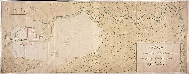
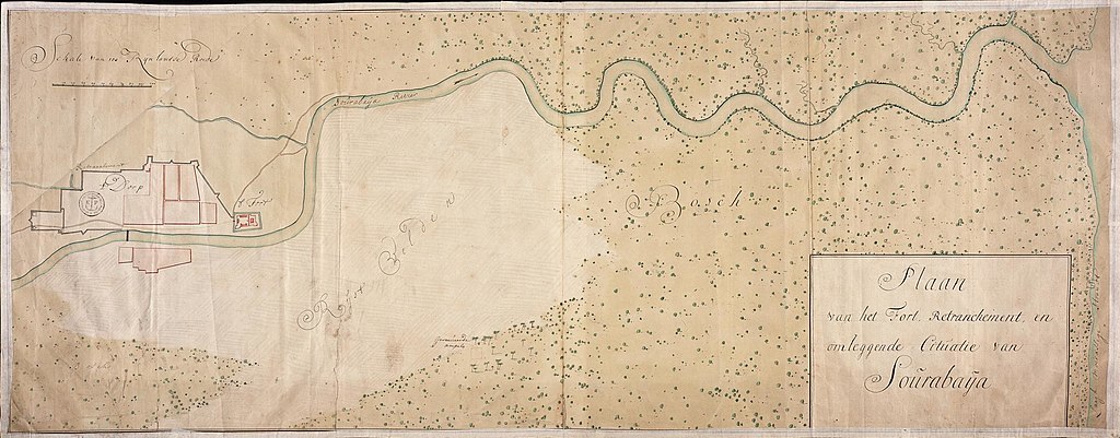
Map of Surabaya
Summary
[edit]| Nederlands: Kaart van Sourabaja
English: Map of Surabaya Bahasa Indonesia: Peta Surabaya( |
||||||||||||||||||||||||
|---|---|---|---|---|---|---|---|---|---|---|---|---|---|---|---|---|---|---|---|---|---|---|---|---|
| Author |
Nederlands: Anoniem / Anonymous (landmeter / kaartenmaker)
English: Anoniem / Anonymous (land surveyor / mapmaker) |
|||||||||||||||||||||||
| Title |
Nederlands: Kaart van Sourabaja
English: Map of Surabaya
Bahasa Indonesia: Peta Surabaya |
|||||||||||||||||||||||
| Description |
Nederlands: Titel catalogus Leupe (NA): Plaan van het fort, Retrenchement en omleggende cituatie van Sourabaya.
Notities verso: Plaan van het fort, Retranchement, en omleggende Cituatie van Sourabaija anno 1719 [twee keer] / No. 82. [op een etiketje] / No. 11 Fort, Retranchement en Situatie van Sourabaija. / Register 2, Deel 1, Folio 6, Portefeuille .. [geschreven op een blauw etiket, no 11 niet helemaal zeker] / 643 [met vette cijfers gestempeld op een etiketje]
English: Title in the Leupe catalogue (NA): Plaan van het fort, Retrenchement en omleggende cituatie van Sourabaya.
Notes on reverse: Plaan van het fort, Retranchement, en omleggende Cituatie van Sourabaija anno 1719 [twice] / No. 82. [on a small label] / No. 11 Fort, Retranchement en Situatie van Sourabaija. / Register 2, Deel 1, Folio 6, Portefeuille .. [inscribed on a blue label, no 11 not entirely clear] / 643 [stamped in bold on a small label]
Bahasa Indonesia: Judul dalam katalog Leupe (AN): Plaan van het fort, Retrenchement en omleggende cituatie van Sourabaya.
Catatan di belakang: Plaan van het fort, Retranchement, en omleggende Cituatie van Sourabaija anno 1719 [dua kali] / No. 82. [dalam label kecil] / No. 11 Fort, Retranchement en Situatie van Sourabaija. / Register 2, Deel 1, Folio 6, Portefeuille .. [ditulis dalam label biru, no 11 tidak terlihat jelas] / 643 [dicetak tebal dalam label kecil] |
|||||||||||||||||||||||
| Date | 1719 | |||||||||||||||||||||||
| Medium |
Nederlands: ingekleurde tekening op papier
English: coloured drawing on paper
Bahasa Indonesia: gambar berwarna di atas kertas |
|||||||||||||||||||||||
| Dimensions | height: 104 cm (40.9 in); width: 41 cm (16.1 in) | |||||||||||||||||||||||
| Collection |
|
|||||||||||||||||||||||
| Accession number |
NL-HaNA_4.VEL_1280 (old number: VEL1280) |
|||||||||||||||||||||||
| Inscriptions |
Plaan van het Fort, Retrenchement en omleggende Cituatie van Sourabaya
|
|||||||||||||||||||||||
| Notes |
English: Subjects: fortification, estate / plantation, chart / map / plan
Nederlands: Onderwerpen: vesting, landerij / plantage, plattegrond / kaart
English: Post: this image is related to a VOC trading post called Surabaya |
|||||||||||||||||||||||
| Source/Photographer |
|
|||||||||||||||||||||||
| Permission (Reusing this file) |
|
|||||||||||||||||||||||

| Object location | | View this and other nearby images on: OpenStreetMap |
|---|
File history
Click on a date/time to view the file as it appeared at that time.
| Date/Time | Thumbnail | Dimensions | User | Comment | |
|---|---|---|---|---|---|
| current | 08:38, 11 June 2014 | 2,400 × 941 (315 KB) | HuskyBot (talk | contribs) | == {{int:filedesc}} == {{Artwork |title = {{nl|1=Kaart van Sourabaja}} {{en|1=Map of Surabaya}} |description = {{nl|1=Titel catalogus Leupe (NA): ''Plaan van het fort, Retrenchement en omleggende cituatie van S... |
You cannot overwrite this file.
File usage on Commons
The following page uses this file: