File:AMH-5577-NA Map of north eastern India.jpg
Jump to navigation
Jump to search

Size of this preview: 800 × 540 pixels. Other resolutions: 320 × 216 pixels | 640 × 432 pixels | 1,024 × 692 pixels | 1,280 × 865 pixels | 2,400 × 1,621 pixels.
Original file (2,400 × 1,621 pixels, file size: 837 KB, MIME type: image/jpeg)
Captions
Captions
Add a one-line explanation of what this file represents
Summary
[edit]Nederlands: Kaart van Noordoost India
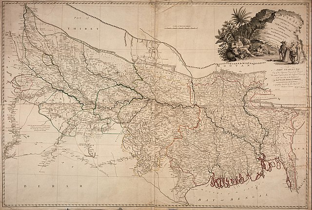
English: Map of north eastern India( |
||||||||||||||||||||||||
|---|---|---|---|---|---|---|---|---|---|---|---|---|---|---|---|---|---|---|---|---|---|---|---|---|
| Author |
Nederlands: William Faden (landmeter / kaartenmaker)
English: William Faden (land surveyor / mapmaker) |
|||||||||||||||||||||||
| Title |
Nederlands: Kaart van Noordoost India
English: Map of north eastern India |
|||||||||||||||||||||||
| Description |
Nederlands: Titel catalogus Leupe (NA): A Map of Bengal, Bahar, Oude and Allahabad, with Part of Agra and Delhi, exhibiting the Course of the Ganges from Hurdwar to the Sea.
Notities verso: van Bengalen [geschreven op een blauw etiket] / 595 [met vette cijfers gestempeld op een etiketje].
English: Title in the Leupe catalogue (NA): A Map of Bengal, Bahar, Oude and Allahabad, with Part of Agra and Delhi, exhibiting the Course of the Ganges from Hurdwar to the Sea.
Notes on reverse: van Bengalen [inscribed on a blue label] / 595 [printed in bold on a small label]. |
|||||||||||||||||||||||
| Date | 1786 | |||||||||||||||||||||||
| Medium |
Nederlands: koperdruk op papier
English: copperplate printing on paper |
|||||||||||||||||||||||
| Dimensions | height: 109 cm (42.9 in); width: 73.5 cm (28.9 in) | |||||||||||||||||||||||
| Collection |
|
|||||||||||||||||||||||
| Accession number |
NL-HaNA_4.VEL_1100 (old number: VEL1100) |
|||||||||||||||||||||||
| Inscriptions |
A Map of Bengal, Bahar, Oude and Allahabad, with Part of Agra and Delhi, exhibiting the Course of the Ganges from Hurdwar to the Sea
author: William Faden |
|||||||||||||||||||||||
| Notes |
English: Subjects: fauna, chart / map / plan, Person, banderole / cartouche / ornamentation
Nederlands: Onderwerpen: fauna, plattegrond / kaart, Persoon, banderol / cartouche / versiering
English: Post: this image is related to a VOC trading post called Chunchura |
|||||||||||||||||||||||
| Source/Photographer |
|
|||||||||||||||||||||||
| Permission (Reusing this file) |
|
|||||||||||||||||||||||

| Object location | | View this and other nearby images on: OpenStreetMap |
|---|
File history
Click on a date/time to view the file as it appeared at that time.
| Date/Time | Thumbnail | Dimensions | User | Comment | |
|---|---|---|---|---|---|
| current | 08:36, 11 June 2014 | | 2,400 × 1,621 (837 KB) | HuskyBot (talk | contribs) | == {{int:filedesc}} == {{Artwork |title = {{nl|1=Kaart van Noordoost India}} {{en|1=Map of north eastern India}} |description = {{nl|1=Titel catalogus Leupe (NA): ''A Map of Bengal, Bahar, Oude and Allahabad, w... |
You cannot overwrite this file.
File usage on Commons
The following page uses this file: