File:AMH-5565-NA Profiles for planned improvements to the castle at Colombo.jpg

Original file (2,400 × 914 pixels, file size: 229 KB, MIME type: image/jpeg)
Captions
Captions
Summary
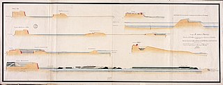
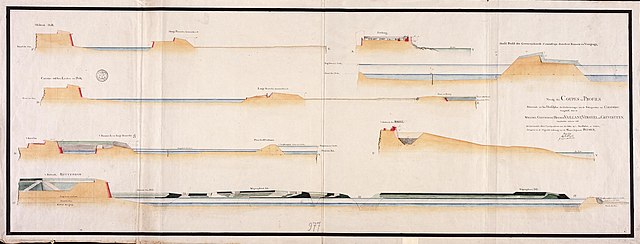
[edit]| Nederlands: Profielen ter verbetering van het kasteel van Colombo
English: Profiles for planned improvements to the castle at Colombo ( |
||||||||||||||||||||||||
|---|---|---|---|---|---|---|---|---|---|---|---|---|---|---|---|---|---|---|---|---|---|---|---|---|
| Author |
Creator:J.F. Reitz Creator:D. Matthysz.
Nederlands: J.F. Reitz (landmeter / kaartenmaker), D. Matthysz. (landmeter / kaartenmaker), Carl Friedrich Reimer (gewerkt naar)
English: J.F. Reitz (land surveyor / mapmaker), D. Matthysz. (land surveyor / mapmaker), Carl Friedrich Reimer (copied after) |
|||||||||||||||||||||||
| Title |
Nederlands: Profielen ter verbetering van het kasteel van Colombo
English: Profiles for planned improvements to the castle at Colombo |
|||||||||||||||||||||||
| Description |
Nederlands: Titel catalogus Leupe (NA): Profilen enz., tot dit plan behoorende, van verschillende afmetingen enz..
Aantekening catalogus Leupe: VEL0977A origineel. Behoort bij de rapporten van de militaire commissie naar de Oost 1789-1792. o.l.v. J.O. Vaillant; C.A. Verhuell en J.F.L. van Gravenstein. Zie NA. Staatssecretarie inv. nr. 1910-1932; Collectie Verhuell nrs. 7-45. Notities verso: No. 16.D. Profilen van Colombo. Register 4, Deel 1, Folio 13, Portefeuille .. [geschreven op een blauw etiket] / No. 1: Littera b: / 537 [in potlood].English: Title in the Leupe catalogue (NA): Profilen enz., tot dit plan behoorende, van verschillende afmetingen enz..
Note in the Leupe catalogue: VEL0977A origineel. Behoort bij de rapporten van de militaire commissie naar de Oost 1789-1792. o.l.v. J.O. Vaillant; C.A. Verhuell en J.F.L. van Gravenstein. Zie NA. Staatssecretarie inv. nr. 1910-1932; Collectie Verhuell nrs. 7-45. Notes on reverse: No. 16.D. Profilen van Colombo. Register 4, Deel 1, Folio 13, Portefeuille .. [inscribed on a blue label] / No. 1: Littera b: / 537 [in pencil]. |
|||||||||||||||||||||||
| Date | circa 1790 | |||||||||||||||||||||||
| Medium |
Nederlands: ingekleurde tekening op papier
English: coloured drawing on paper |
|||||||||||||||||||||||
| Dimensions | height: 127.5 cm (50.1 in); width: 48.5 cm (19 in) | |||||||||||||||||||||||
| Collection |
|
|||||||||||||||||||||||
| Accession number |
NL-HaNA_4.VEL_977E (old number: VEL0977E) |
|||||||||||||||||||||||
| Inscriptions |
Vervolg der Coupes en Profils [...]
author: door Matthijsz |
|||||||||||||||||||||||
| Notes |
English: Subjects: survey / view, fortification, cross-section / profile
Nederlands: Onderwerpen: overzicht / aanzicht, vesting, doorsnede / profiel
English: Fort: this image is related to a VOC fort called kasteel Colombo |
|||||||||||||||||||||||
| Source/Photographer |
|
|||||||||||||||||||||||
| Permission (Reusing this file) |
|
|||||||||||||||||||||||

| Object location | | View this and other nearby images on: OpenStreetMap |
|---|
File history
Click on a date/time to view the file as it appeared at that time.
| Date/Time | Thumbnail | Dimensions | User | Comment | |
|---|---|---|---|---|---|
| current | 08:33, 11 June 2014 | 2,400 × 914 (229 KB) | HuskyBot (talk | contribs) | == {{int:filedesc}} == {{Artwork |title = {{nl|1=Profielen ter verbetering van het kasteel van Colombo}} {{en|1=Profiles for planned improvements to the castle at Colombo}} |description = {{nl|1=Titel catalogus... |
You cannot overwrite this file.
File usage on Commons
The following page uses this file: