File:AMH-5541-NA Map of the south eastern islands.jpg
Jump to navigation
Jump to search

Size of this preview: 800 × 537 pixels. Other resolutions: 320 × 215 pixels | 640 × 430 pixels | 1,024 × 687 pixels | 1,280 × 859 pixels | 2,400 × 1,611 pixels.
Original file (2,400 × 1,611 pixels, file size: 457 KB, MIME type: image/jpeg)
Captions
Captions
Add a one-line explanation of what this file represents
Summary
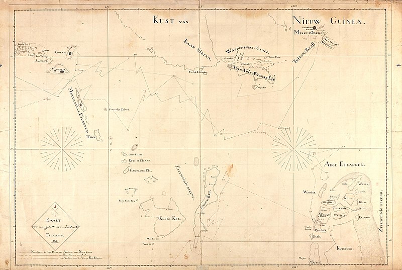
[edit]Nederlands: Kaart van de Zuid-Ooster eilanden
English: Map of the south eastern islands( |
||||||||||||||||||||||||
|---|---|---|---|---|---|---|---|---|---|---|---|---|---|---|---|---|---|---|---|---|---|---|---|---|
| Author | ||||||||||||||||||||||||
| Title |
Nederlands: Kaart van de Zuid-Ooster eilanden
English: Map of the south eastern islands |
|||||||||||||||||||||||
| Description |
Nederlands: Titel catalogus Leupe (NA): Kaart van een gedeelte der Zuidooster Eilanden.
English: Title in the Leupe catalogue (NA): Kaart van een gedeelte der Zuidooster Eilanden. |
|||||||||||||||||||||||
| Date | 1836 | |||||||||||||||||||||||
| Medium |
Nederlands: pen op papier
English: pen on paper |
|||||||||||||||||||||||
| Dimensions | height: 99 cm (38.9 in); width: 67.5 cm (26.5 in) | |||||||||||||||||||||||
| Collection |
|
|||||||||||||||||||||||
| Accession number |
NL-HaNA_4.VEL_486 (old number: VEL0486) |
|||||||||||||||||||||||
| Inscriptions |
Kaart van een gedeelte der Zuidooster Eilanden
author: M. van Vreeland |
|||||||||||||||||||||||
| Notes |
English: Subjects: banderole / cartouche / ornamentation, chart / map / plan
Nederlands: Onderwerpen: banderol / cartouche / versiering, plattegrond / kaart
English: Post: this image is related to a WIC trading post called Wokam |
|||||||||||||||||||||||
| Source/Photographer |
|
|||||||||||||||||||||||
| Permission (Reusing this file) |
|
|||||||||||||||||||||||

| Object location | | View this and other nearby images on: OpenStreetMap |
|---|
File history
Click on a date/time to view the file as it appeared at that time.
| Date/Time | Thumbnail | Dimensions | User | Comment | |
|---|---|---|---|---|---|
| current | 08:28, 11 June 2014 | | 2,400 × 1,611 (457 KB) | HuskyBot (talk | contribs) | == {{int:filedesc}} == {{Artwork |title = {{nl|1=Kaart van de Zuid-Ooster eilanden}} {{en|1=Map of the south eastern islands}} |description = {{nl|1=Titel catalogus Leupe (NA): ''Kaart van een gedeelte der Zuid... |
You cannot overwrite this file.
File usage on Commons
The following page uses this file: