File:AMH-5537-NA Map of the south coast of Java.jpg
Jump to navigation
Jump to search

Size of this preview: 800 × 479 pixels. Other resolutions: 320 × 192 pixels | 640 × 383 pixels | 1,024 × 614 pixels | 1,280 × 767 pixels | 2,400 × 1,438 pixels.
Original file (2,400 × 1,438 pixels, file size: 430 KB, MIME type: image/jpeg)
Captions
Captions
Add a one-line explanation of what this file represents
Summary
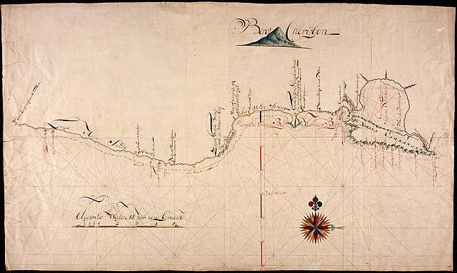
[edit]Nederlands: Kaart van de zuidkust van Java
English: Map of the south coast of Java( |
||||||||||||||||||||||||
|---|---|---|---|---|---|---|---|---|---|---|---|---|---|---|---|---|---|---|---|---|---|---|---|---|
| Author |
Nederlands: Anoniem / Anonymous (landmeter / kaartenmaker)
English: Anoniem / Anonymous (land surveyor / mapmaker) |
|||||||||||||||||||||||
| Title |
Nederlands: Kaart van de zuidkust van Java
English: Map of the south coast of Java |
|||||||||||||||||||||||
| Description |
Nederlands: Titel catalogus Leupe (NA): Kaart als voren, van een laag afloopende hoeck tot de rivier den Donau.
English: Title in the Leupe catalogue (NA): Kaart als voren, van een laag afloopende hoeck tot de rivier den Donau. |
|||||||||||||||||||||||
| Date | between 1700 and 1800 | |||||||||||||||||||||||
| Medium |
Nederlands: ingekleurde tekening op papier
English: coloured drawing on paper |
|||||||||||||||||||||||
| Dimensions | height: 124.5 cm (49 in); width: 74 cm (29.1 in) | |||||||||||||||||||||||
| Collection |
|
|||||||||||||||||||||||
| Accession number |
NL-HaNA_4.VEL_439 (old number: VEL0439) |
|||||||||||||||||||||||
| Inscriptions |
-
|
|||||||||||||||||||||||
| Notes |
English: Subjects: chart / map / plan, compass / dial
Nederlands: Onderwerpen: plattegrond / kaart, kompas / windroos |
|||||||||||||||||||||||
| Source/Photographer |
|
|||||||||||||||||||||||
| Permission (Reusing this file) |
|
|||||||||||||||||||||||

File history
Click on a date/time to view the file as it appeared at that time.
| Date/Time | Thumbnail | Dimensions | User | Comment | |
|---|---|---|---|---|---|
| current | 08:27, 11 June 2014 | | 2,400 × 1,438 (430 KB) | HuskyBot (talk | contribs) | == {{int:filedesc}} == {{Artwork |title = {{nl|1=Kaart van de zuidkust van Java}} {{en|1=Map of the south coast of Java}} |description = {{nl|1=Titel catalogus Leupe (NA): ''Kaart als voren, van een laag afloop... |
You cannot overwrite this file.
File usage on Commons
The following page uses this file: