File:AMH-5535-NA Map of the northern coast of Java and Madura.jpg
Jump to navigation
Jump to search

Size of this preview: 800 × 545 pixels. Other resolutions: 320 × 218 pixels | 640 × 436 pixels | 1,024 × 697 pixels | 1,280 × 871 pixels | 2,400 × 1,634 pixels.
Original file (2,400 × 1,634 pixels, file size: 663 KB, MIME type: image/jpeg)
Captions
Captions
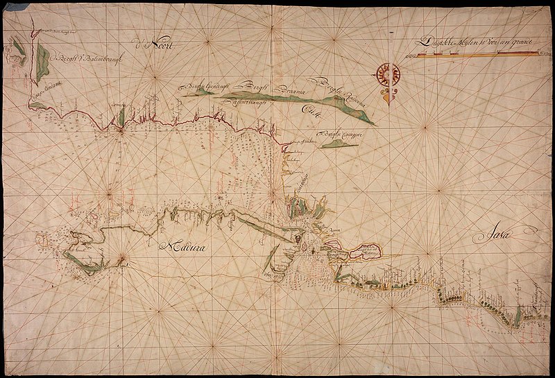
Map of the northern coast of Java and Madura
Summary
[edit]Nederlands: Kaart van de noordkust van Java en Madura
                     English:  Map of the northern coast of Java and Madura
                     Bahasa Indonesia:  Peta pantai utara Jawa dan Madura
( |
||||||||||||||||||||||||
|---|---|---|---|---|---|---|---|---|---|---|---|---|---|---|---|---|---|---|---|---|---|---|---|---|
| Author |
Nederlands: Anoniem / Anonymous (landmeter / kaartenmaker), J. Hudden (toegeschreven aan landmeter/kaartenmaker)
English: Anoniem / Anonymous (land surveyor / mapmaker), J. Hudden (assigned to land surveyor / mapmaker) |
|||||||||||||||||||||||
| Title |
Nederlands: Kaart van de noordkust van Java en Madura
English: Map of the northern coast of Java and Madura
Bahasa Indonesia: Peta pantai utara Jawa dan Madura |
|||||||||||||||||||||||
| Description |
Nederlands: Titel catalogus Leupe (NA): Kaart van de Straat Madoera, tusschen Rembang en Kaap Sandana.
De kaart is op blauw papier geplakt.
English: Title in the Leupe catalogue (NA): Kaart van de Straat Madoera, tusschen Rembang en Kaap Sandana.
The map has been pasted on blue paper.
Bahasa Indonesia: Judul dalam katalog Leupe (AN): Kaart van de Straat Madoera, tusschen Rembang en Kaap Sandana.
Peta ini telah direkatkan pada kertas biru. |
|||||||||||||||||||||||
| Date | circa 1740 | |||||||||||||||||||||||
| Medium |
Nederlands: ingekleurde tekening op papier
English: coloured drawing on paper
Bahasa Indonesia: gambar berwarna di atas kertas |
|||||||||||||||||||||||
| Dimensions | height: 102.5 cm (40.3 in); width: 70 cm (27.5 in) | |||||||||||||||||||||||
| Collection |
|
|||||||||||||||||||||||
| Accession number |
NL-HaNA_4.VEL_431 (old number: VEL0431) |
|||||||||||||||||||||||
| Inscriptions |
-
|
|||||||||||||||||||||||
| Notes |
English: Subjects: chart / map / plan, compass / dial
Nederlands: Onderwerpen: plattegrond / kaart, kompas / windroos
English: Post: this image is related to a VOC trading post called Surabaya |
|||||||||||||||||||||||
| Source/Photographer |
|
|||||||||||||||||||||||
| Permission (Reusing this file) |
|
|||||||||||||||||||||||

| Object location | | View this and other nearby images on: OpenStreetMap |
|---|
File history
Click on a date/time to view the file as it appeared at that time.
| Date/Time | Thumbnail | Dimensions | User | Comment | |
|---|---|---|---|---|---|
| current | 08:27, 11 June 2014 | | 2,400 × 1,634 (663 KB) | HuskyBot (talk | contribs) | == {{int:filedesc}} == {{Artwork |title = {{nl|1=Kaart van de noordkust van Java en Madura}} {{en|1=Map of the northern coast of Java and Madura}} |description = {{nl|1=Titel catalogus Leupe (NA): ''Kaart van d... |
You cannot overwrite this file.
File usage on Commons
The following page uses this file: