File:AMH-5527-NA Map of the Soenda Straits.jpg
Jump to navigation
Jump to search

Size of this preview: 729 × 600 pixels. Other resolutions: 292 × 240 pixels | 583 × 480 pixels | 933 × 768 pixels | 1,244 × 1,024 pixels | 2,400 × 1,975 pixels.
Original file (2,400 × 1,975 pixels, file size: 822 KB, MIME type: image/jpeg)
Captions
Captions
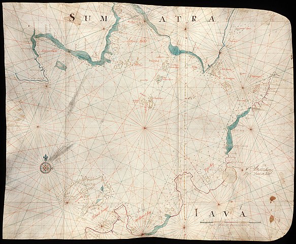
Map of the Soenda Straits
Summary
[edit]| Nederlands: Kaart van de Straat Soenda
English: Map of the Soenda Straits Bahasa Indonesia: Peta Selat Sunda( |
||||||||||||||||||||||||||
|---|---|---|---|---|---|---|---|---|---|---|---|---|---|---|---|---|---|---|---|---|---|---|---|---|---|---|
| Author |
Nederlands: Isaac de Graaff (uitgever)
English: Isaac de Graaff (publisher) |
|||||||||||||||||||||||||
| Title |
Nederlands: Kaart van de Straat Soenda
English: Map of the Soenda Straits
Bahasa Indonesia: Peta Selat Sunda |
|||||||||||||||||||||||||
| Description |
Nederlands: Titel catalogus Leupe (NA): Kaart van Straat Soenda, van het Princen-Eyland tot den Hoek van Bantam.
De baai hier aangeduid met 'Keysers Bocht', werd ook wel de 'Bocht Samanca' genoemd.
English: Title in the Leupe catalogue (NA): Kaart van Straat Soenda, van het Princen-Eyland tot den Hoek van Bantam.
The bay indicated here as 'Keysers Bocht', was also known as the 'Bocht Samanca'.
Bahasa Indonesia: Judul dalam katalog Leupe (AN): Kaart van Straat Soenda, van het Princen-Eyland tot den Hoek van Bantam.
Teluk yang ditunjukkan di sini sebagai 'Keysers Bocht', juga dikenal sebagai 'Bocht Samanca'. |
|||||||||||||||||||||||||
| Date | 1738 | |||||||||||||||||||||||||
| Medium |
Nederlands: ingekleurde tekening op perkament
English: coloured drawing on parchment
Bahasa Indonesia: gambar berwarna di atas perkamen |
|||||||||||||||||||||||||
| Dimensions | height: 82 cm (32.2 in); width: 67 cm (26.3 in) | |||||||||||||||||||||||||
| Collection |
|
|||||||||||||||||||||||||
| Accession number |
NL-HaNA_4.VEL_356 (old number: VEL0356) |
|||||||||||||||||||||||||
| Inscriptions |
-
author: 1738 T' Amsterdam bij Isaak de Graaf |
|||||||||||||||||||||||||
| Notes |
English: Subjects: chart / map / plan, compass / dial
Nederlands: Onderwerpen: plattegrond / kaart, kompas / windroos
English: Post: this image is related to a VOC trading post called Anyar |
|||||||||||||||||||||||||
| Source/Photographer |
|
|||||||||||||||||||||||||
| Permission (Reusing this file) |
|
|||||||||||||||||||||||||

| Object location | | View this and other nearby images on: OpenStreetMap |
|---|
File history
Click on a date/time to view the file as it appeared at that time.
| Date/Time | Thumbnail | Dimensions | User | Comment | |
|---|---|---|---|---|---|
| current | 08:25, 11 June 2014 | | 2,400 × 1,975 (822 KB) | HuskyBot (talk | contribs) | == {{int:filedesc}} == {{Artwork |title = {{nl|1=Kaart van de Straat Soenda}} {{en|1=Map of the Soenda Straits}} |description = {{nl|1=Titel catalogus Leupe (NA): ''Kaart van Straat Soenda, van het Princen-Eyla... |
You cannot overwrite this file.
File usage on Commons
The following page uses this file:
File usage on other wikis
The following other wikis use this file:
- Usage on nl.wikipedia.org