File:AMH-5422-NA Map of part of the northern coast of Java, in the Batavia area.jpg
Jump to navigation
Jump to search

Size of this preview: 800 × 566 pixels. Other resolutions: 320 × 227 pixels | 640 × 453 pixels | 1,024 × 725 pixels | 1,280 × 906 pixels | 2,400 × 1,699 pixels.
Original file (2,400 × 1,699 pixels, file size: 682 KB, MIME type: image/jpeg)
Captions
Captions
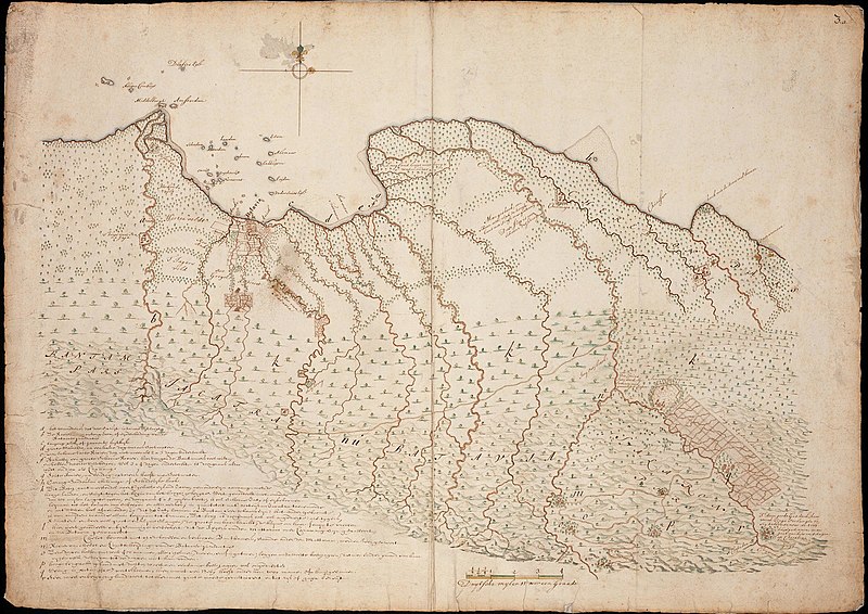
Map of part of the northern coast of Java, in the Batavia area
Summary
[edit]| Author |
Nederlands: Isaac de Graaff (landmeter / kaartenmaker)
English: Isaac de Graaff (land surveyor / mapmaker) |
|||||||||||||||||||||||||
| Title |
Nederlands: Kaart van een deel van de noordkust van Java, omgeving Batavia
English: Map of part of the northern coast of Java, in the Batavia area
Bahasa Indonesia: Peta sebagian pantai utara di Pulau Jawa, tepat di sekitar Batavia |
|||||||||||||||||||||||||
| Description |
Nederlands: Titel catalogus Leupe (NA): Kaart als voren, aan de Noordkust tusschen Ontong Java en Pamenoecan, hiermee wordt bedoeld de titel van VEL1159: Kaart van een gedeelte van het eiland Java.
Rechtsboven genummerd 3.a. Afkomstig uit de Atlas Amsterdam. Notities verso: 602 e Legenda: a-rEnglish: Title in the Leupe catalogue (NA): Kaart als voren, aan de Noordkust tusschen Ontong Java en Pamenoecan, in reference to the title of VEL1159: Kaart van een gedeelte van het eiland Java.
Numbered top right 3.a. Originates from the Atlas Amsterdam. Notes on reverse: 602 eBahasa Indonesia: Judul dalam katalog Leupe (NA): Kaart als voren, aan de Noordkust tusschen Ontong Java en Pamenoecan, merujuk pada judul peta VEL1159: Kaart van een gedeelte van het eiland Java.
Diberi nomor di kanan atas 3.a. Bersumber dari Atlas Amsterdam. Catatan di belakang: 602 e |
|||||||||||||||||||||||||
| Date | between 1690 and 1743 | |||||||||||||||||||||||||
| Medium |
Nederlands: ingekleurde tekening op papier
English: coloured drawing on paper
Bahasa Indonesia: gambar berwarna di atas kertas |
|||||||||||||||||||||||||
| Dimensions | height: 74 cm (29.1 in); width: 52.5 cm (20.6 in) | |||||||||||||||||||||||||
| Collection |
|
|||||||||||||||||||||||||
| Accession number |
NL-HaNA_4.VEL_1160 (old number: VEL1160) |
|||||||||||||||||||||||||
| Inscriptions |
-
|
|||||||||||||||||||||||||
| Notes |
English: Subjects: key, chart / map / plan
Nederlands: Onderwerpen: legenda, plattegrond / kaart
English: Post: this image is related to a VOC trading post called Jakarta |
|||||||||||||||||||||||||
| Source/Photographer |
|
|||||||||||||||||||||||||
| Permission (Reusing this file) |
|
|||||||||||||||||||||||||

| Object location | | View this and other nearby images on: OpenStreetMap |
|---|
File history
Click on a date/time to view the file as it appeared at that time.
| Date/Time | Thumbnail | Dimensions | User | Comment | |
|---|---|---|---|---|---|
| current | 18:17, 10 June 2014 | | 2,400 × 1,699 (682 KB) | HuskyBot (talk | contribs) | == {{int:filedesc}} == {{Artwork |title = {{nl|1=Kaart van een deel van de noordkust van Java, omgeving Batavia}} {{en|1=Map of part of the northern coast of Java, in the Batavia area}} |description = {{nl|1=Ti... |
You cannot overwrite this file.
File usage on Commons
The following page uses this file: