File:AMH-5395-NA Map of Paleacatte.jpg
Jump to navigation
Jump to search

Size of this preview: 399 × 599 pixels. Other resolutions: 160 × 240 pixels | 319 × 480 pixels | 511 × 768 pixels | 682 × 1,024 pixels | 1,598 × 2,400 pixels.
Original file (1,598 × 2,400 pixels, file size: 387 KB, MIME type: image/jpeg)
Captions
Captions
Add a one-line explanation of what this file represents
Summary
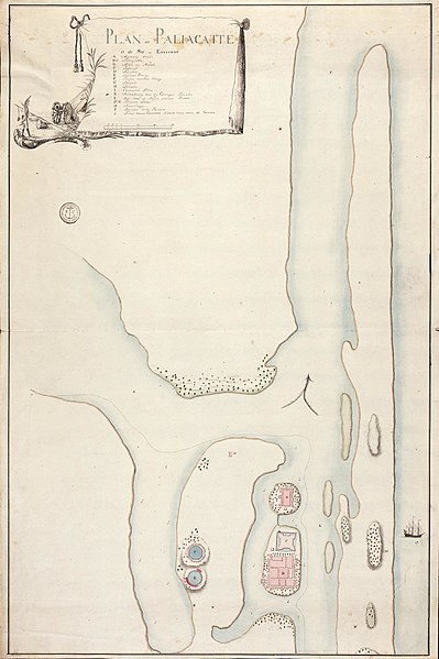
[edit]Nederlands: Plattegrond van Paleacatte
English: Map of Paleacatte( |
||||||||||||||||||||||||
|---|---|---|---|---|---|---|---|---|---|---|---|---|---|---|---|---|---|---|---|---|---|---|---|---|
| Author |
Nederlands: Anoniem / Anonymous (landmeter / kaartenmaker)
English: Anoniem / Anonymous (land surveyor / mapmaker) |
|||||||||||||||||||||||
| Title |
Nederlands: Plattegrond van Paleacatte
English: Map of Paleacatte |
|||||||||||||||||||||||
| Description |
Nederlands: Titel catalogus Leupe (NA): Plan de Paliacatte et de ses Environs.
Notities verso: No. 13 Plan van Pallicatte. Register 6, Deel 1, Folio 28, Portefeuille .. [geschreven op een blauw etiket] / 589a [met vette cijfers gestempeld op een etiketje] / tot no. 45 [klein geschreven, in rechterbovenhoek].
English: Title in the Leupe catalogue (NA): Plan de Paliacatte et de ses Environs.
Notes on reverse: No. 13 Plan van Pallicatte. Register 6, Deel 1, Folio 28, Portefeuille .. [inscribed on a blue label] / 589a [printed on a small label in bold] / tot no. 45 [written small in top right corner]. |
|||||||||||||||||||||||
| Date | between 1700 and 1800 | |||||||||||||||||||||||
| Medium |
Nederlands: ingekleurde tekening op papier
English: coloured drawing on paper |
|||||||||||||||||||||||
| Dimensions | height: 49.5 cm (19.4 in); width: 75 cm (29.5 in) | |||||||||||||||||||||||
| Collection |
|
|||||||||||||||||||||||
| Accession number |
NL-HaNA_4.VEL_1091 (old number: VEL1091) |
|||||||||||||||||||||||
| Inscriptions |
Plan de la Paliacatte
|
|||||||||||||||||||||||
| Notes |
English: Subjects: Person, ship / vessel, key, fortification, art / object, banderole / cartouche / ornamentation, chart / map / plan
Nederlands: Onderwerpen: Persoon, schip / vaartuig, legenda, vesting, kunst(nijverheid) / object, banderol / cartouche / versiering, plattegrond / kaart
English: Post: this image is related to a VOC trading post called Pulicat |
|||||||||||||||||||||||
| Source/Photographer |
|
|||||||||||||||||||||||
| Permission (Reusing this file) |
|
|||||||||||||||||||||||

| Object location | | View this and other nearby images on: OpenStreetMap |
|---|
File history
Click on a date/time to view the file as it appeared at that time.
| Date/Time | Thumbnail | Dimensions | User | Comment | |
|---|---|---|---|---|---|
| current | 18:13, 10 June 2014 | | 1,598 × 2,400 (387 KB) | HuskyBot (talk | contribs) | == {{int:filedesc}} == {{Artwork |title = {{nl|1=Plattegrond van Paleacatte}} {{en|1=Map of Paleacatte}} |description = {{nl|1=Titel catalogus Leupe (NA): ''Plan de Paliacatte et de ses Environs''. Notities ve... |
You cannot overwrite this file.
File usage on Commons
The following page uses this file: