File:AMH-5255-NA Map of the east coast of Celebes.jpg
Jump to navigation
Jump to search
Size of this preview: 800 × 568 pixels. Other resolutions: 320 × 227 pixels | 640 × 455 pixels | 1,024 × 727 pixels | 1,280 × 909 pixels | 2,400 × 1,705 pixels.
Original file (2,400 × 1,705 pixels, file size: 514 KB, MIME type: image/jpeg)
Captions
Captions
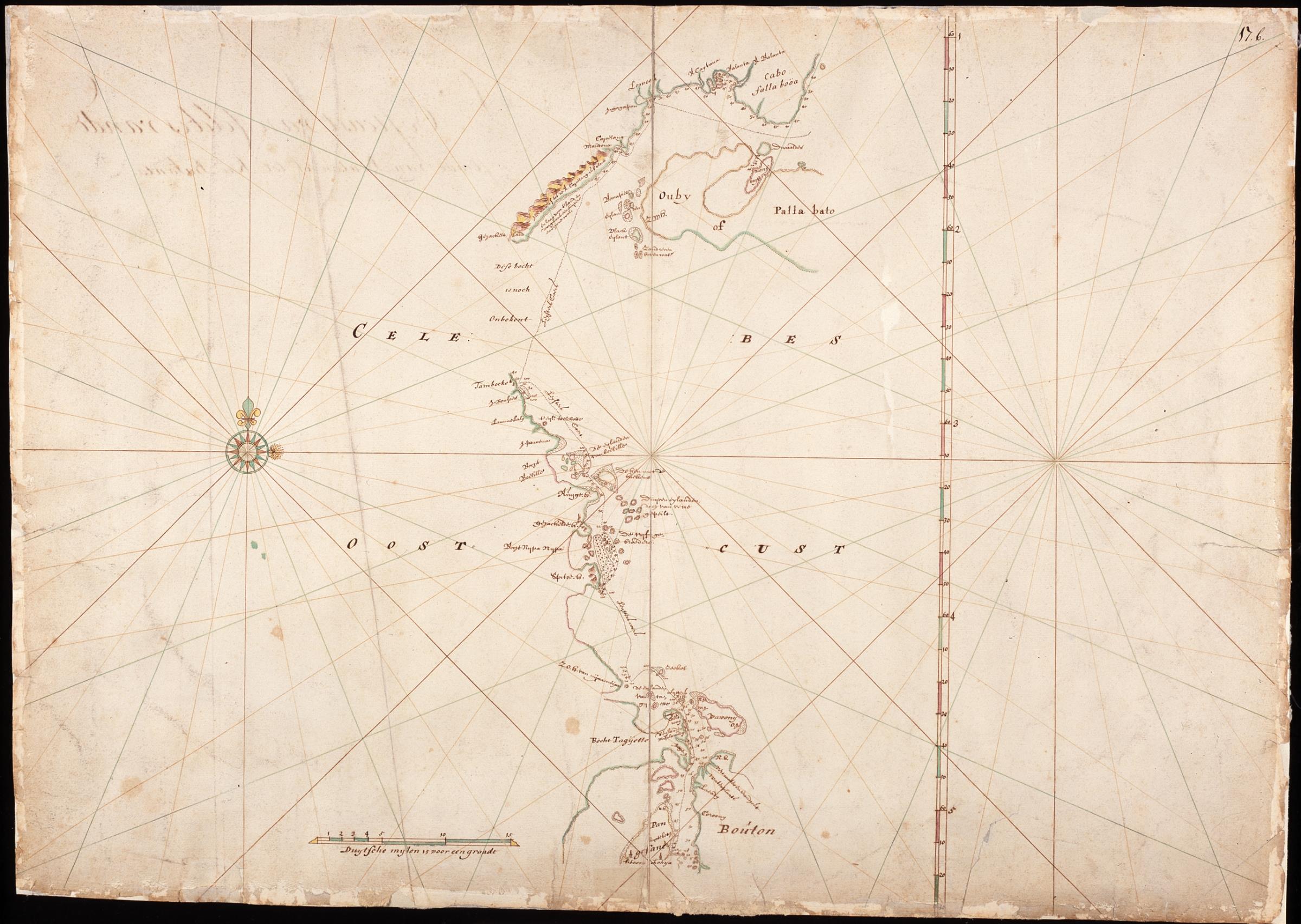
Map of the east coast of Celebes
Summary
[edit]Nederlands: Kaart van de oostkust van Celebes
                     English:  Map of the east coast of Celebes
                     Bahasa Indonesia:  Peta pantai timur Sulawesi
( |
||||||||||||||||||||||||||
|---|---|---|---|---|---|---|---|---|---|---|---|---|---|---|---|---|---|---|---|---|---|---|---|---|---|---|
| Author |
Nederlands: Isaac de Graaff (landmeter / kaartenmaker)
English: Isaac de Graaff (land surveyor / mapmaker) |
|||||||||||||||||||||||||
| Title |
Nederlands: Kaart van de oostkust van Celebes
English: Map of the east coast of Celebes
Bahasa Indonesia: Peta pantai timur Sulawesi |
|||||||||||||||||||||||||
| Description |
Nederlands: Titel in catalogus Leupe (NA): Kaart van de Oostkust van Celebes), van Straat Bouton tot Cabo Falla Boea (Talabo of Taljabo).
Rechtsboven genummerd: 17.b. Notities verso: D'Oostcust van Celebes vande Straat van Bouton af tot Rio Balanta / D'Oostcust van Celebes), beseylt met de Hoeker de Brandgans anno 1682.English: Title in the Leupe catalogue (National Archives): Kaart van de Oostkust van Celebes), van Straat Bouton tot Cabo Falla Boea (Talabo of Taljabo).
Numbered top right: 17.b. Notes on reverse: D'Oostcust van Celebes vande Straat van Bouton af tot Rio Balanta / D'Oostcust van Celebes), beseylt met de Hoeker de Brandgans anno 1682.Bahasa Indonesia: Judul dalam katalog Leupe (Arsip Nasional): Kaart van de Oostkust van Celebes), van Straat Bouton tot Cabo Falla Boea (Talabo of Taljabo).
Nomor di kanan atas: 17.b. Catatan di belakang: D'Oostcust van Celebes vande Straat van Bouton af tot Rio Balanta / D'Oostcust van Celebes), beseylt met de Hoeker de Brandgans anno 1682. |
|||||||||||||||||||||||||
| Date | between 1690 and 1743 | |||||||||||||||||||||||||
| Medium |
Nederlands: ingekleurde tekening op papier
English: coloured drawing on paper
Bahasa Indonesia: gambar berwarna di atas kertas |
|||||||||||||||||||||||||
| Dimensions | height: 74.5 cm (29.3 in); width: 53 cm (20.8 in) | |||||||||||||||||||||||||
| Collection |
|
|||||||||||||||||||||||||
| Accession number |
NL-HaNA_4.VEL_465 (old number: VEL0465) |
|||||||||||||||||||||||||
| Inscriptions |
Celebes oostcust
|
|||||||||||||||||||||||||
| Notes |
English: Subjects: chart / map / plan, compass / dial
Nederlands: Onderwerpen: plattegrond / kaart, kompas / windroos
English: Post: this image is related to a VOC trading post called Baubau |
|||||||||||||||||||||||||
| Source/Photographer |
|
|||||||||||||||||||||||||
| Permission (Reusing this file) |
|
|||||||||||||||||||||||||

| Object location | | View this and other nearby images on: OpenStreetMap |
|---|
File history
Click on a date/time to view the file as it appeared at that time.
| Date/Time | Thumbnail | Dimensions | User | Comment | |
|---|---|---|---|---|---|
| current | 17:47, 10 June 2014 | | 2,400 × 1,705 (514 KB) | HuskyBot (talk | contribs) | == {{int:filedesc}} == {{Artwork |title = {{nl|1=Kaart van de oostkust van Celebes}} {{en|1=Map of the east coast of Celebes}} |description = {{nl|1=Titel in catalogus Leupe (NA): ''Kaart van de Oostkust van Ce... |
You cannot overwrite this file.
File usage on Commons
The following page uses this file: