File:AMH-5246-NA Map of part of the north coast of the island of Sumbawa.jpg
Original file (2,400 × 1,688 pixels, file size: 457 KB, MIME type: image/jpeg)
Captions
Captions
Summary
[edit]| Author |
Nederlands: Isaac de Graaff (landmeter / kaartenmaker)
English: Isaac de Graaff (land surveyor / mapmaker) |
|||||||||||||||||||||||||
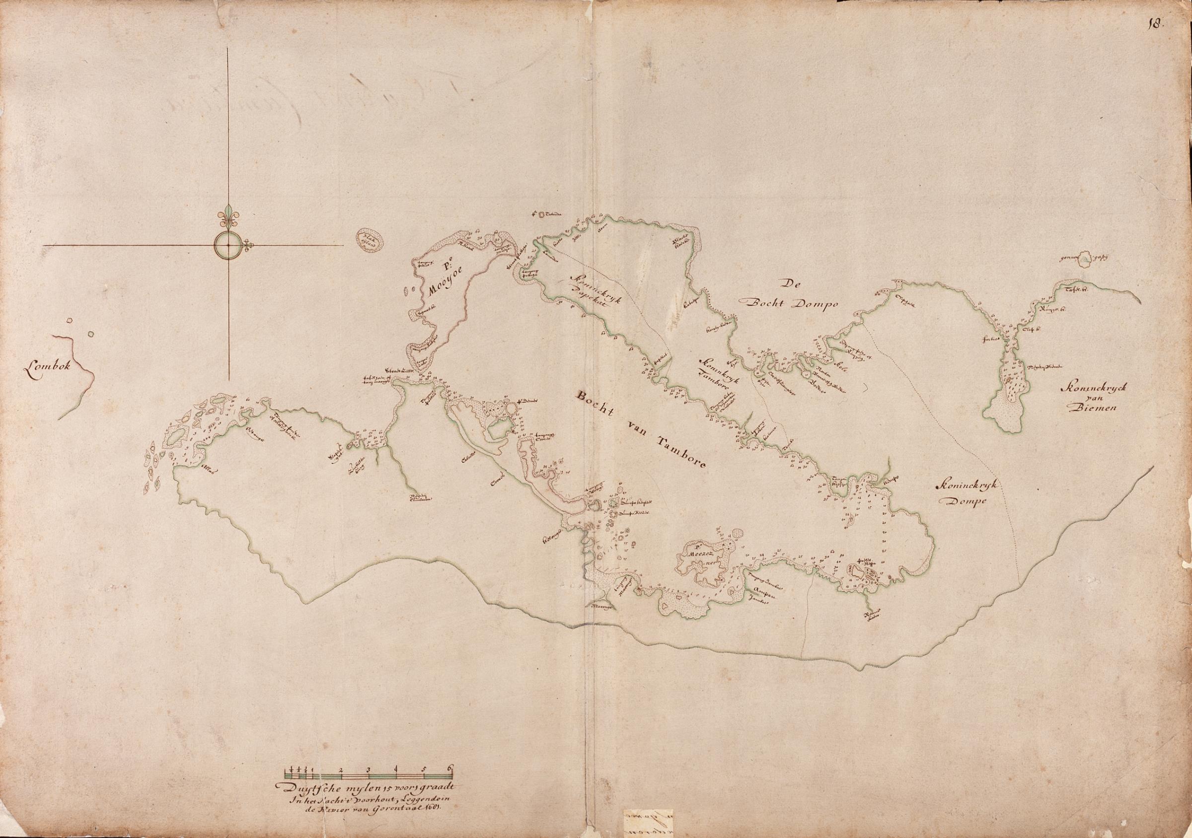
| Title |
Nederlands: Kaart van een deel van de noordkust van het eiland Sumbawa
English: Map of part of the north coast of the island of Sumbawa
Bahasa Indonesia: Peta sebagian pantai utara pulau Sumbawa |
|||||||||||||||||||||||||
| Description |
Nederlands: Titel in catalogus Leupe (NA): Kaart van een gedeelte der Noordkust van het Eiland Sumbawa, bevattende de Bogt van Tambore, Dompo, Bima enz..
Rechtsboven genummerd: 18.. De achterkant is beplakt met een vel papier, heel vaag zijn nog potloodnummers te zien. Opmerking in catalogus Leupe: De kaart is vervaardigd in het jacht Voorhout, liggende in de rivier van Gorontale., daarmee wordt bedoeld het voorbeeld voor de kaart die hier wordt weergegeven. Dit voorbeeld is vervaardigd ca. 1681. Notities verso: 'T Eijland Cumbava. [in een uitsparing van het vel papier].English: Title in the Leupe catalogue (National Archives): Kaart van een gedeelte der Noordkust van het Eiland Sumbawa, bevattende de Bogt van Tambore, Dompo, Bima enz..
Numbered top right: 18.. A piece of paper has been pasted on the reverse, pencilled numbers may still be vaguely discerned. Note in the Leupe catalogue: De kaart is vervaardigd in het jacht Voorhout, liggende in de rivier van Gorontale.. The description of the location refers to the map from which the chart here depicted was copied. The chart illustrated here was made around 1681. Notes on reverse: 'T Eijland Cumbava. [revealed by a cutaway in the sheet of paper pasted on the reverse].Bahasa Indonesia: Judul dalam katalog Leupe (Arsip Nasional): Kaart van een gedeelte der Noordkust van het Eiland Sumbawa, bevattende de Bogt van Tambore, Dompo, Bima enz..
Diberi nomor di kanan atas: 18.. Secarik kertas telah ditempelkan di bagian belakang, angka-angka dengan pensil mungkin masih terlihat samar-samar. Catatan dalam katalog Leupe: De kaart is vervaardigd in het jacht Voorhout, liggende in de rivier van Gorontale.. Deskripsi lokasi mengacu pada peta dari mana bagan yang digambarkan di sini disalin. Bagan yang diilustrasikan di sini dibuat sekitar tahun 1681. Catatan di belakang: 'T Eijland Cumbava. [dituliskan pada potongan kertas yang disisipkan di bagian belakang]. |
|||||||||||||||||||||||||
| Date | between 1690 and 1743 | |||||||||||||||||||||||||
| Medium |
Nederlands: ingekleurde tekening op papier
English: coloured drawing on paper
Bahasa Indonesia: gambar berwarna di atas kertas |
|||||||||||||||||||||||||
| Dimensions | height: 75 cm (29.5 in); width: 53 cm (20.8 in) | |||||||||||||||||||||||||
| Collection |
|
|||||||||||||||||||||||||
| Accession number |
NL-HaNA_4.VEL_452 (old number: VEL0452) |
|||||||||||||||||||||||||
| Inscriptions |
-
|
|||||||||||||||||||||||||
| Notes |
English: Subjects: chart / map / plan
Nederlands: Onderwerpen: plattegrond / kaart
English: Post: this image is related to a VOC trading post called Bima |
|||||||||||||||||||||||||
| Source/Photographer |
|
|||||||||||||||||||||||||
| Permission (Reusing this file) |
|
|||||||||||||||||||||||||

| Object location | | View this and other nearby images on: OpenStreetMap |
|---|
File history
Click on a date/time to view the file as it appeared at that time.
| Date/Time | Thumbnail | Dimensions | User | Comment | |
|---|---|---|---|---|---|
| current | 17:45, 10 June 2014 | | 2,400 × 1,688 (457 KB) | HuskyBot (talk | contribs) | == {{int:filedesc}} == {{Artwork |title = {{nl|1=Kaart van een deel van de noordkust van het eiland Sumbawa}} {{en|1=Map of part of the north coast of the island of Sumbawa}} |description = {{nl|1=Titel in cata... |
You cannot overwrite this file.
File usage on Commons
The following page uses this file: