File:AMH-4838-NA Map of a part of the northern Java coast, part 2.jpg

Original file (2,400 × 1,890 pixels, file size: 764 KB, MIME type: image/jpeg)
Captions
Captions
Summary
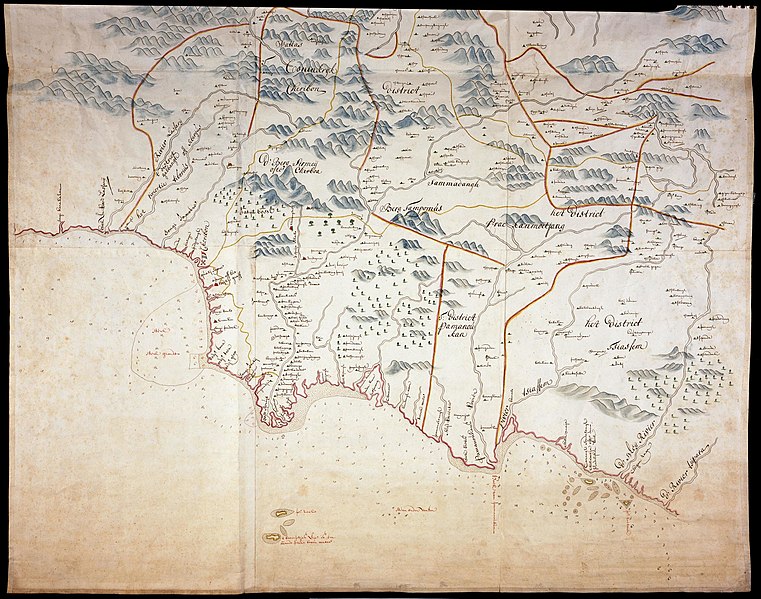
[edit]Nederlands: Kaart van een deel van de noordkust van Java, deel 2
                     English:  Map of a part of the northern Java coast, part 2
                     Bahasa Indonesia:  Peta sebagian pantai utara Jawa, bagian 2.
( |
||||||||||||||||||||||||
|---|---|---|---|---|---|---|---|---|---|---|---|---|---|---|---|---|---|---|---|---|---|---|---|---|
| Author |
Nederlands: Anoniem / Anonymous (landmeter / kaartenmaker)
English: Anoniem / Anonymous (land surveyor / mapmaker) |
|||||||||||||||||||||||
| Title |
Nederlands: Kaart van een deel van de noordkust van Java, deel 2
English: Map of a part of the northern Java coast, part 2
Bahasa Indonesia: Peta sebagian pantai utara Jawa, bagian 2. |
|||||||||||||||||||||||
| Description |
Nederlands: Titel catalogus Leupe (NA): Kaart van een gedeelte van het Eiland Java: aan de Noordkust, van de rivier Tsippara tot aan Soengi Karakahan, en aan de Zuidkust, van Soekapoera tot de Zoute rivier.
Notities verso: No. 18. Cheribon en de Preanger Landen / d 602. Zes bladen gezamenlijk. Zie ook Nationaal Archief, inv.nr. VEL1159_1.English: Title in the Leupe catalogue (NA): Kaart van een gedeelte van het Eiland Java: aan de Noordkust, van de rivier Tsippara tot aan Soengi Karakahan, en aan de Zuidkust, van Soekapoera tot de Zoute rivier.
Notes on reverse: No. 18. Cheribon en de Preanger Landen / d 602. Enam lembar terlihat menyatu. Lihat juga Arsip Nasional, inv.nr. VEL1159_1.Bahasa Indonesia: Judul dalam katalog Leupe (NA): Kaart van een gedeelte van het Eiland Java: aan de Noordkust, van de rivier Tsippara tot aan Soengi Karakahan, en aan de Zuidkust, van Soekapoera tot de Zoute rivier.
Catatan di belakang: No. 18. Cheribon en de Preanger Landen / d 602. Six leaves altogether. See also the National Archives, inv.nr. VEL1159_1. |
|||||||||||||||||||||||
| Date | between 1700 and 1750 | |||||||||||||||||||||||
| Medium |
Nederlands: ingekleurde tekening op papier
English: coloured drawing on paper
Bahasa Indonesia: gambar berwarna di atas kertas |
|||||||||||||||||||||||
| Dimensions | height: 104.5 cm (41.1 in); width: 146 cm (57.4 in) | |||||||||||||||||||||||
| Collection |
|
|||||||||||||||||||||||
| Accession number |
NL-HaNA_4.VEL_1159.2 (old number: VEL1159_2) |
|||||||||||||||||||||||
| Notes |
English: Subjects: chart / map / plan, compass / dial
Nederlands: Onderwerpen: plattegrond / kaart, kompas / windroos |
|||||||||||||||||||||||
| Source/Photographer |
|
|||||||||||||||||||||||
| Permission (Reusing this file) |
|
|||||||||||||||||||||||

File history
Click on a date/time to view the file as it appeared at that time.
| Date/Time | Thumbnail | Dimensions | User | Comment | |
|---|---|---|---|---|---|
| current | 17:13, 10 June 2014 | | 2,400 × 1,890 (764 KB) | HuskyBot (talk | contribs) | == {{int:filedesc}} == {{Artwork |title = {{nl|1=Kaart van een deel van de noordkust van Java, deel 2}} {{en|1=Map of a part of the northern Java coast, part 2}} |description = {{nl|1=Titel catalogus Leupe (NA)... |
You cannot overwrite this file.
File usage on Commons
The following page uses this file: