File:AMH-4708-NA Maps of the fortifications on Saparoua.jpg
Original file (2,400 × 1,708 pixels, file size: 436 KB, MIME type: image/jpeg)
Captions
Captions
Summary
[edit]Nederlands: Plattegronden van de fortificaties op Saparoua
                     English:  Maps of the fortifications on Saparoua
                     Bahasa Indonesia:  Peta benteng di Saparua
( |
||||||||||||||||||||||||||
|---|---|---|---|---|---|---|---|---|---|---|---|---|---|---|---|---|---|---|---|---|---|---|---|---|---|---|
| Author |
Nederlands: Isaac de Graaff (landmeter / kaartenmaker)
English: Isaac de Graaff (land surveyor / mapmaker) |
|||||||||||||||||||||||||
| Title |
Nederlands: Plattegronden van de fortificaties op Saparoua
English: Maps of the fortifications on Saparoua
Bahasa Indonesia: Peta benteng di Saparua |
|||||||||||||||||||||||||
| Description |
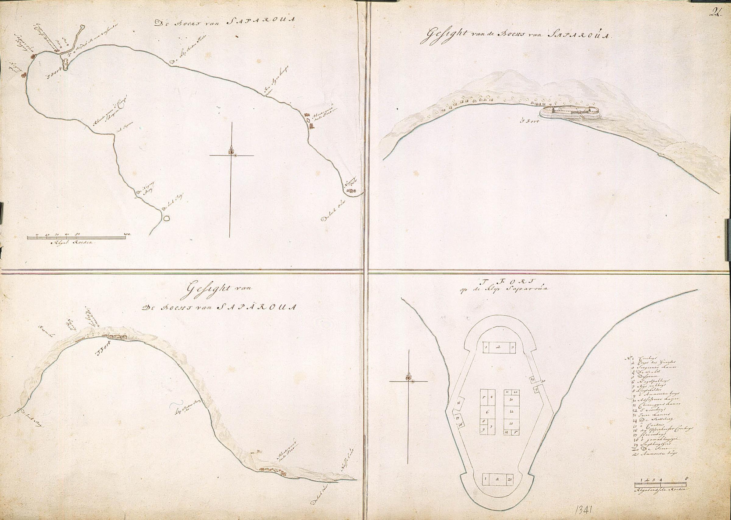
Nederlands: Titel catalogus Leupe (NA): De bocht van Saparoua.
VEL1341a: Gesight van de bocht van Saparoua. VEL1341b: Gesight op het fort in de bocht van Saparoua. VEL1341c: Platte grond van 't fort op de klip Saparoua. Rechts boven genummerd: 24. 100 Rijnlandse roeden = 98 strepen; omgerekende schaal [1 : 3842] [bocht Saparoua] / 8 Rijnlandse roeden = 50 strepen; omgerekende schaal [1 : 602] [fort op klip Saparoua].English: According to the Leupe catalogue (NA), the original title reads: De bocht van Saparoua.
VEL1341a: Gesight van de bocht van Saparoua. VEL1341b: Gesight op het fort in de bocht van Saparoua. VEL1341c: Platte grond van 't fort op de klip Saparoua. Numbered top right: 24. 100 Rhenish rods = 98 stripes; converted scale [1 : 3842] [Saparoua bend] / 8 Rhenish rods = 50 stripes; converted scale [1 : 602] [fort on Saparoua cliff].Bahasa Indonesia: Menurut katalog Leupe (NA), judul aslinya berbunyi: De bocht van Saparoua.
VEL1341a: Gesight van de bocht van Saparoua. VEL1341b: Gesight op het fort in de bocht van Saparoua. VEL1341c: Platte grond van 't fort op de klip Saparoua. Diberi nomor di kanan atas: 24. 100 Rhenish rods = 98 stripes; converted scale [1 : 3842] [Saparoua bend] / 8 Rhenish rods = 50 stripes; converted scale [1 : 602] [fort on Saparoua cliff]. |
|||||||||||||||||||||||||
| Date | between 1690 and 1705 | |||||||||||||||||||||||||
| Medium |
Nederlands: ingekleurde tekening op papier
English: coloured drawing on paper
Bahasa Indonesia: gambar berwarna di atas kertas |
|||||||||||||||||||||||||
| Dimensions | height: 72.5 cm (28.5 in); width: 52.5 cm (20.6 in) | |||||||||||||||||||||||||
| Collection |
|
|||||||||||||||||||||||||
| Accession number |
NL-HaNA_4.VEL_1341 (old number: VEL1341) |
|||||||||||||||||||||||||
| Inscriptions |
De bocht van Saparoua / Gesight van de bocht van Saparoua / Gesight op van de bocht van Saparoua / 't fort op de klip Saparoua
|
|||||||||||||||||||||||||
| Notes |
English: Subjects: fortification, chart / map / plan, shipyard
Nederlands: Onderwerpen: vesting, plattegrond / kaart, scheeps- / timmerwerf
English: Post: this image is related to a VOC trading post called Saparua eiland |
|||||||||||||||||||||||||
| Source/Photographer |
|
|||||||||||||||||||||||||
| Permission (Reusing this file) |
|
|||||||||||||||||||||||||

| Object location | | View this and other nearby images on: OpenStreetMap |
|---|
File history
Click on a date/time to view the file as it appeared at that time.
| Date/Time | Thumbnail | Dimensions | User | Comment | |
|---|---|---|---|---|---|
| current | 17:05, 10 June 2014 | | 2,400 × 1,708 (436 KB) | HuskyBot (talk | contribs) | == {{int:filedesc}} == {{Artwork |title = {{nl|1=Plattegronden van de fortificaties op Saparoua}} {{en|1=Maps of the fortifications on Saparoua}} |description = {{nl|1=Titel catalogus Leupe (NA): ''De bocht van... |
You cannot overwrite this file.
File usage on Commons
The following page uses this file: