File:AMH-4705-NA Design for fortifications at Amboina.jpg
Jump to navigation
Jump to search

Size of this preview: 800 × 548 pixels. Other resolutions: 320 × 219 pixels | 640 × 439 pixels | 1,024 × 702 pixels | 1,280 × 877 pixels | 2,400 × 1,645 pixels.
Original file (2,400 × 1,645 pixels, file size: 508 KB, MIME type: image/jpeg)
Captions
Captions
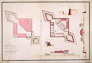
Design for fortifications at Amboina
Summary
[edit]| Nederlands: Ontwerp voor fortificaties te Amboina
English: Design for fortifications at Amboina Bahasa Indonesia: Desain untuk benteng di Amboina ( |
||||||||||||||||||||||||
|---|---|---|---|---|---|---|---|---|---|---|---|---|---|---|---|---|---|---|---|---|---|---|---|---|
| Author |
Nederlands: P. Elias (landmeter / kaartenmaker), Carl Friedrich Reimer (gewerkt naar), I.O. Vaillant (opdrachtgever), C.A. Verhuell (opdrachtgever), J.F.L van Gravestein (opdrachtgever)
English: P. Elias (land surveyor / mapmaker), Carl Friedrich Reimer (copied after), I.O. Vaillant (patron), C.A. Verhuell (patron), J.F.L van Gravestein (patron) |
|||||||||||||||||||||||
| Title |
Nederlands: Ontwerp voor fortificaties te Amboina
English: Design for fortifications at Amboina
Bahasa Indonesia: Desain untuk benteng di Amboina |
|||||||||||||||||||||||
| Description |
Nederlands: Titel catalogus Leupe (NA): Gedetaileert project tot kleine forten met en zonder retraite enz. van Amboina.
Genummerd: No. 7. Notities verso: No. 7 / 659 [met vette cijfers gestempeld op een etiketje].English: According to the Leupe catalogue (NA), the original title reads: Gedetaileert project tot kleine forten met en zonder retraite enz. van Amboina.
Numbered: No. 7. Notes on reverse: No. 7 / 659 [stamped in bold on a label].Bahasa Indonesia: Menurut katalog Leupe (NA), judul aslinya berbunyi: Gedetaileert project tot kleine forten met en zonder retraite enz. van Amboina.
Diberi nomor: No. 7. Catatan di belakang: No. 7 / 659 [dicetak tebal pada label kecil]. |
|||||||||||||||||||||||
| Date | circa 1750 | |||||||||||||||||||||||
| Medium |
Nederlands: ingekleurde tekening op papier
English: coloured drawing on paper
Bahasa Indonesia: gambar berwarna di atas kertas |
|||||||||||||||||||||||
| Dimensions | height: 82.5 cm (32.4 in); width: 57.5 cm (22.6 in) | |||||||||||||||||||||||
| Collection |
|
|||||||||||||||||||||||
| Accession number |
NL-HaNA_4.VEL_1338 (old number: VEL1338) |
|||||||||||||||||||||||
| Inscriptions |
N:o 1 / Gedetaileert project tot kleine forten met en zonder retraite betrekkelijk tot de memorie over de sterktens van Amboina [...] ter ordre van de weledelgestrenge Heeren Vaillant, Verhuel en Graevestein Commissarissen militair enz. enz. author: gecopieerd door P. Elias |
|||||||||||||||||||||||
| Notes |
English: Subjects: cross-section / profile, chart / map / plan, fortification, survey / view
Nederlands: Onderwerpen: doorsnede / profiel, plattegrond / kaart, vesting, overzicht / aanzicht
English: Post: this image is related to a VOC trading post called Ambon |
|||||||||||||||||||||||
| Source/Photographer |
|
|||||||||||||||||||||||
| Permission (Reusing this file) |
|
|||||||||||||||||||||||

| Object location | | View this and other nearby images on: OpenStreetMap |
|---|
File history
Click on a date/time to view the file as it appeared at that time.
| Date/Time | Thumbnail | Dimensions | User | Comment | |
|---|---|---|---|---|---|
| current | 17:04, 10 June 2014 | | 2,400 × 1,645 (508 KB) | HuskyBot (talk | contribs) | == {{int:filedesc}} == {{Artwork |title = {{nl|1=Ontwerp voor fortificaties te Amboina}} {{en|1=Design for fortifications at Amboina}} |description = {{nl|1=Titel catalogus Leupe (NA): ''Gedetaileert project to... |
You cannot overwrite this file.
File usage on Commons
The following page uses this file: