File:AMH-4669-NA Map of the old fort at Grisse and several elevations.jpg

Original file (2,400 × 1,844 pixels, file size: 615 KB, MIME type: image/jpeg)
Captions
Captions
Summary
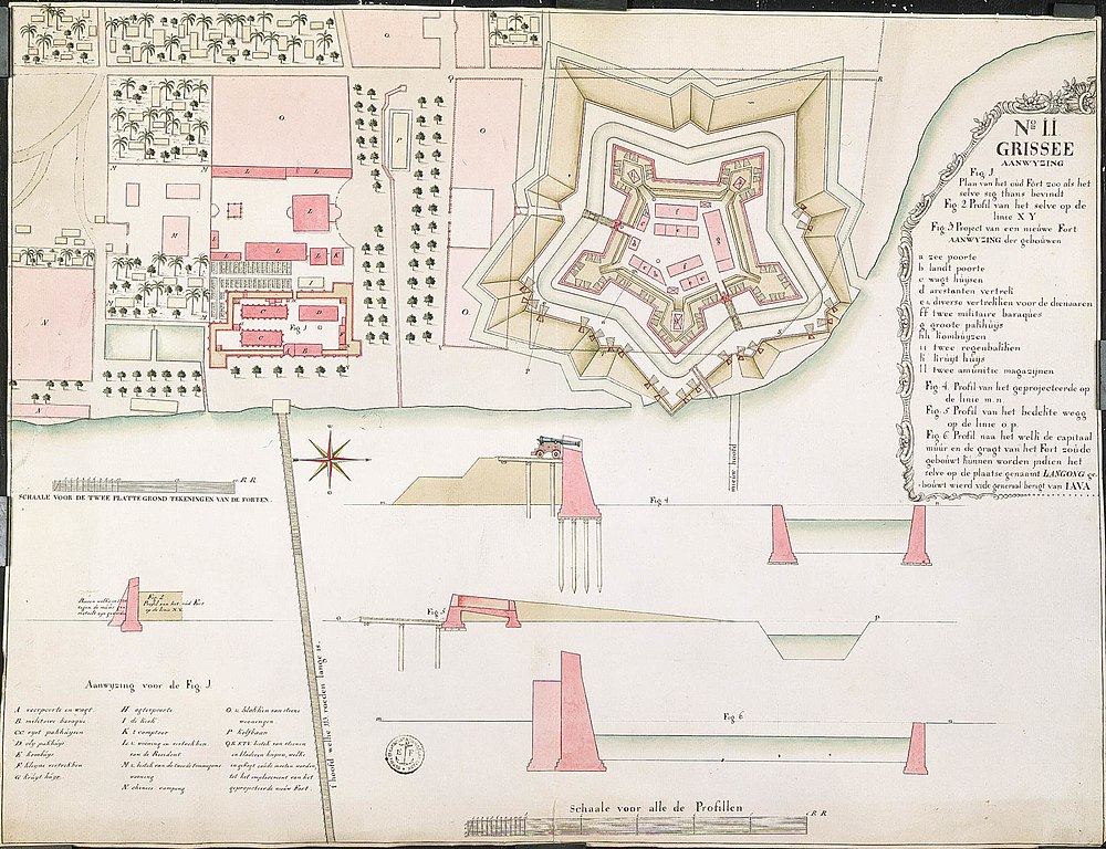
[edit]| Nederlands: Kaart van het oude fort van Grisse en enkele profielen
English: Map of the old fort at Grisse and several elevations Bahasa Indonesia: Peta benteng tua di Grisse dan beberapa elevasi( |
||||||||||||||||||||||||
|---|---|---|---|---|---|---|---|---|---|---|---|---|---|---|---|---|---|---|---|---|---|---|---|---|
| Author |
Nederlands: Anoniem / Anonymous
English: Anoniem / Anonymous |
|||||||||||||||||||||||
| Title |
Nederlands: Kaart van het oude fort van Grisse en enkele profielen
English: Map of the old fort at Grisse and several elevations
Bahasa Indonesia: Peta benteng tua di Grisse dan beberapa elevasi |
|||||||||||||||||||||||
| Description |
Nederlands: Titel catalogus Leupe (NA): Plan van het oude fort zoo als hetzelve zich thans bevind.
VEL1278a: Project van een nieuwe fort. Legenda: A-V Stempeltje: Depot des Cart. Pl. et Journ. de la Marine. Notities verso: 20ste 7ber 1787 [er staat ook nog tekst voor de datum 20ste maar daar is het blauwe etiket overheen geplakt] / No. 20 Grisse Register 2 Deel 1 Folio 7 Portefeul [geschreven op een blauw etiket] / No. 11 / 642 [met vette cijfers gestempeld op een etiketje] / grise [in potlood] / no. 19. 30 Rijnlandse roeden = 104 strepen; omgerekende schaal [1 : 1086] [voor de forten] / 6 Rijnlandse roeden = 203 strepen; omgerekende schaal [1 : 111] [voor de profielen].English: According to the Leupe catalogue (NA), the original title reads: Plan van het oude fort zoo als hetzelve zich thans bevind.
VEL1278a: Project van een nieuwe fort. Key: A-V Stamp: Depot des Cart. Pl. et Journ. de la Marine. Notes on reverse: 20ste 7ber 1787 [the date 20ste is preceded by text, but the label has been pasted over it] / No. 20 Grisse Register 2 Deel 1 Folio 7 Portefeul [written on a blue label] / No. 11 / 642 [stamped in bold on a small label] / grise [in pencil] / no. 19. 30 Rhenish rods = 104 stripes; converted scale [1 : 1086] [for the forts] / 6 Rhenish rods = 203 stripes; converted scale [1 : 111] [for the elevations].Bahasa Indonesia: Menurut katalog Leupe (NA), judul aslinya berbunyi: Plan van het oude fort zoo als hetzelve zich thans bevind.
VEL1278a: Project van een nieuwe fort. Kunci: A-V Stempel: Depot des Cart. Pl. et Journ. de la Marine. Catatan di belakang: 20ste 7ber 1787 [tanggal '20ste' didahului oleh teks, tetapi sebuah label telah ditempelkan di atasnya] / No. 20 Grisse Register 2 Deel 1 Folio 7 Portefeul [ditulis di atas label biru] / No. 11 / 642 [dicetak tebal pada label kecil] / grise [dalam pensil] / no. 19. 30 Rhenish rods = 104 stripes; converted scale [1 : 1086] [for the forts] / 6 Rhenish rods = 203 stripes; converted scale [1 : 111] [for the elevations]. |
|||||||||||||||||||||||
| Date | circa 1787 | |||||||||||||||||||||||
| Medium |
Nederlands: ingekleurde tekening op papier
English: coloured drawing on paper
Bahasa Indonesia: gambar berwarna di atas kertas |
|||||||||||||||||||||||
| Dimensions | height: 66 cm (25.9 in); width: 50.5 cm (19.8 in) | |||||||||||||||||||||||
| Collection |
|
|||||||||||||||||||||||
| Accession number |
NL-HaNA_4.VEL_1278 (old number: VEL1278) |
|||||||||||||||||||||||
| Inscriptions |
N:o 11 / Grissee
|
|||||||||||||||||||||||
| Notes |
English: Subjects: bird's-eye view / elevation, elevation / bird's-eye view, cross-section / profile, compass / dial, key, chart / map / plan, fortification
Nederlands: Onderwerpen: vogelvlucht / opstand, opstand / vogelvlucht, doorsnede / profiel, kompas / windroos, legenda, plattegrond / kaart, vesting
English: Post: this image is related to a VOC trading post called Gresik |
|||||||||||||||||||||||
| Source/Photographer |
|
|||||||||||||||||||||||
| Permission (Reusing this file) |
|
|||||||||||||||||||||||

| Object location | | View this and other nearby images on: OpenStreetMap |
|---|
File history
Click on a date/time to view the file as it appeared at that time.
| Date/Time | Thumbnail | Dimensions | User | Comment | |
|---|---|---|---|---|---|
| current | 16:57, 10 June 2014 | | 2,400 × 1,844 (615 KB) | HuskyBot (talk | contribs) | == {{int:filedesc}} == {{Artwork |title = {{nl|1=Kaart van het oude fort van Grisse en enkele profielen}} {{en|1=Map of the old fort at Grisse and several elevations}} |description = {{nl|1=Titel catalogus Leup... |
You cannot overwrite this file.
File usage on Commons
The following page uses this file: