File:AMH-4668-NA Map of the Rembang.jpg

Original file (1,843 × 2,400 pixels, file size: 465 KB, MIME type: image/jpeg)
Captions
Captions
Summary
[edit]| Nederlands: Plattegrond van Rembang
English: Map of Rembang Bahasa Indonesia: Peta Rembang ( |
||||||||||||||||||||||||
|---|---|---|---|---|---|---|---|---|---|---|---|---|---|---|---|---|---|---|---|---|---|---|---|---|
| Author |
Nederlands: Anoniem / Anonymous
English: Anoniem / Anonymous |
|||||||||||||||||||||||
| Title |
Nederlands: Plattegrond van Rembang
English: Map of Rembang
Bahasa Indonesia: Peta Rembang |
|||||||||||||||||||||||
| Description |
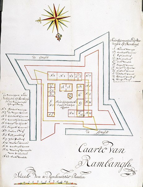
Nederlands: Titel catalogus Leupe (NA): Caarte van Rembang.
Legenda: 1-13; A-L Formaat: 66 x 49 cm [gemeten aan de bovenkant van de kaart] 66 x 51 cm [gemeten aan de onderkant van de kaart]. De kaart is slordig uit de band gesneden, zodat links onder nog een extra strookje papier zit. Notities verso: vier Caarten van de nieuw geprojecteerde paggers tot Damak, Japara en Rembang / 656 [moet het folionummer in de band OBP zijn].English: According to the Leupe catalogue (NA), the original title reads: Caarte van Rembang.
Key: 1-13; A-L Format: 66 x 49 cm [measured along the top edge of the map] 66 x 51 cm [measured along the bottom edge of the map]. The map has been carelessly excised from the volume, resulting in an extra strip of paper bottom left. Notes on reverse: vier Caarten van de nieuw geprojecteerde paggers tot Damak, Japara en Rembang / 656 [must be the folio number in the OBP volume].Bahasa Indonesia: Menurut katalog Leupe (NA), judul aslinya berbunyi: Caarte van Rembang.
Kunci: 1-13; A-L Format: 66 x 49 cm [diukur di sepanjang tepi atas peta] 66 x 51 cm [diukur di sepanjang tepi bawah peta]. Peta telah dipotong secara sembarangan dari buku, menghasilkan potongan kertas tambahan di kiri bawah. Catatan di belakang: vier Caarten van de nieuw geprojecteerde paggers tot Damak, Japara en Rembang / 656 [seharusnya nomor folio dalam volume OBP]. |
|||||||||||||||||||||||
| Date | circa 1709 | |||||||||||||||||||||||
| Medium |
Nederlands: ingekleurde tekening op papier
English: coloured drawing on paper
Bahasa Indonesia: gambar berwarna di atas kertas |
|||||||||||||||||||||||
| Dimensions | height: 49 cm (19.2 in); width: 66 cm (25.9 in) | |||||||||||||||||||||||
| Collection |
|
|||||||||||||||||||||||
| Accession number |
NL-HaNA_4.VEL_1276 (old number: VEL1276) |
|||||||||||||||||||||||
| Inscriptions |
Caarte van Rambangh
|
|||||||||||||||||||||||
| Notes |
English: Subjects: key, compass / dial, fortification, chart / map / plan
Nederlands: Onderwerpen: legenda, kompas / windroos, vesting, plattegrond / kaart
English: Post: this image is related to a VOC trading post called Rembang |
|||||||||||||||||||||||
| Source/Photographer |
|
|||||||||||||||||||||||
| Permission (Reusing this file) |
|
|||||||||||||||||||||||

| Object location | | View this and other nearby images on: OpenStreetMap |
|---|
File history
Click on a date/time to view the file as it appeared at that time.
| Date/Time | Thumbnail | Dimensions | User | Comment | |
|---|---|---|---|---|---|
| current | 16:57, 10 June 2014 | | 1,843 × 2,400 (465 KB) | HuskyBot (talk | contribs) | == {{int:filedesc}} == {{Artwork |title = {{nl|1=Plattegrond van Rembang}} {{en|1=Map of the Rembang}} |description = {{nl|1=Titel catalogus Leupe (NA): ''Caarte van Rembang''. Legenda: 1-13; A-L Formaat: 66... |
You cannot overwrite this file.
File usage on Commons
The following page uses this file:
File usage on other wikis
The following other wikis use this file:
- Usage on nl.wikipedia.org