File:AMH-4654-NA Map of Cheribon.jpg
Original file (2,400 × 1,838 pixels, file size: 683 KB, MIME type: image/jpeg)
Captions
Captions
Summary
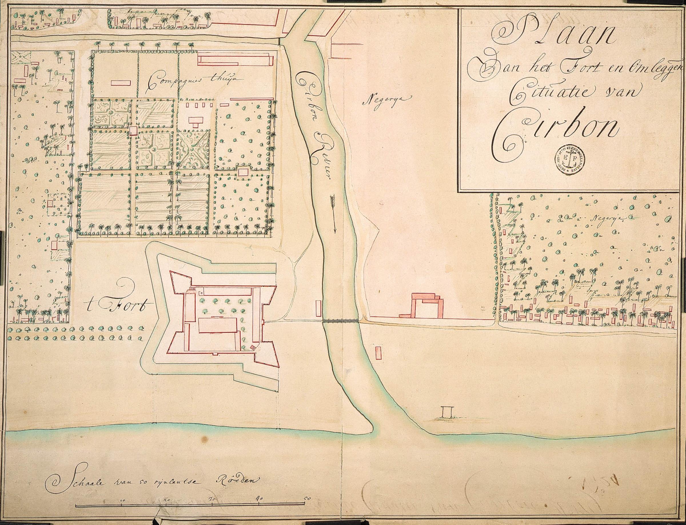
[edit]Nederlands: Plattegrond van Cheribon
                     English:  Map of Cheribon
                     Bahasa Indonesia:  Peta Cirebon
( |
||||||||||||||||||||||||
|---|---|---|---|---|---|---|---|---|---|---|---|---|---|---|---|---|---|---|---|---|---|---|---|---|
| Author |
Nederlands: Anoniem / Anonymous
English: Anoniem / Anonymous |
|||||||||||||||||||||||
| Title |
Nederlands: Plattegrond van Cheribon
English: Map of Cheribon
Bahasa Indonesia: Peta Cirebon |
|||||||||||||||||||||||
| Description |
Nederlands: Titel catalogus Leupe (NA): Plaan van het Fort en omleggende Cituatie van Cirbon.
Stempeltje: Depot des Cart. Pl. et Journ. de la Marine. De middenvouw is aan de onderkant 8 cm ingescheurd. Notities verso: Plaan van het fort en omleggende cituatie van Cheribon Ao 1719 [staat zowel aan de boven als aan de onderkant] / No. 24 [waarschijnlijk het volgnummer van het stuk in de band OBP] / No. 23 Fort en Situatie van Cheribon Register 2 Deel 1 Folio 8 Por-tefeul [geschreven op een blauw etiket] / 625 [met vette cijfers gestempeld op een etiketje] / 198.English: According to the Leupe catalogue (NA), the original title reads: Plaan van het Fort en omleggende Cituatie van Cirbon.
Stamp: Depot des Cart. Pl. et Journ. de la Marine. The centre fold has a tear of 8 cm in length at the bottom. Notes on reverse: Plaan van het fort en omleggende cituatie van Cheribon Ao 1719 [written along the top and the bottom] / No. 24 [probably the number of the item in the OBP volume] / No. 23 Fort en Situatie van Cheribon Register 2 Deel 1 Folio 8 Por-tefeul [written on a blue label] / 625 [stamped in bold on a small label] / 198.Bahasa Indonesia: Menurut katalog Leupe (NA), judul aslinya berbunyi: Plaan van het Fort en omleggende Cituatie van Cirbon.
Stempel: Depot des Cart. Pl. et Journ. de la Marine. Lipatan tengah memiliki robekan sepanjang 8 cm di bagian bawah. Catatan di belakang: Plaan van het fort en omleggende cituatie van Cheribon Ao 1719 [tertulis di bagian atas dan bawah] / No. 24 [mungkin jumlah item dalam volume OBP] / No. 23 Fort en Situatie van Cheribon Register 2 Deel 1 Folio 8 Por-tefeul [ditulis pada label biru] / 625 [dicetak tebal pada label kecil] / 198. |
|||||||||||||||||||||||
| Date | circa 1719 | |||||||||||||||||||||||
| Medium |
Nederlands: ingekleurde tekening op papier
English: coloured drawing on paper
Bahasa Indonesia: gambar berwarna di atas kertas |
|||||||||||||||||||||||
| Dimensions | height: 53 cm (20.8 in); width: 41 cm (16.1 in) | |||||||||||||||||||||||
| Collection |
|
|||||||||||||||||||||||
| Accession number |
NL-HaNA_4.VEL_1252 (old number: VEL1252) |
|||||||||||||||||||||||
| Inscriptions |
Plaan van het Fort en omleggende Cituatie van Cirbon
|
|||||||||||||||||||||||
| Notes |
English: Subjects: estate / plantation, banderole / cartouche / ornamentation, fortification, chart / map / plan
Nederlands: Onderwerpen: landerij / plantage, banderol / cartouche / versiering, vesting, plattegrond / kaart
English: Post: this image is related to a VOC trading post called Cirebon |
|||||||||||||||||||||||
| Source/Photographer |
|
|||||||||||||||||||||||
| Permission (Reusing this file) |
|
|||||||||||||||||||||||

| Object location | | View this and other nearby images on: OpenStreetMap |
|---|
File history
Click on a date/time to view the file as it appeared at that time.
| Date/Time | Thumbnail | Dimensions | User | Comment | |
|---|---|---|---|---|---|
| current | 16:54, 10 June 2014 | | 2,400 × 1,838 (683 KB) | HuskyBot (talk | contribs) | == {{int:filedesc}} == {{Artwork |title = {{nl|1=Plattegrond van Cheribon}} {{en|1=Map of Cheribon}} |description = {{nl|1=Titel catalogus Leupe (NA): ''Plaan van het Fort en omleggende Cituatie van Cirbon''.... |
You cannot overwrite this file.
File usage on Commons
The following page uses this file:
File usage on other wikis
The following other wikis use this file:
- Usage on id.wikipedia.org