File:AMH-4631-NA Map of the Tanjong Poera entrenchment.jpg
Jump to navigation
Jump to search

Size of this preview: 285 × 599 pixels. Other resolutions: 114 × 240 pixels | 228 × 480 pixels | 365 × 768 pixels | 1,142 × 2,400 pixels.
Original file (1,142 × 2,400 pixels, file size: 312 KB, MIME type: image/jpeg)
Captions
Captions
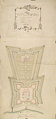
Map of the Tanjong Poera entrenchment
Summary
[edit]Nederlands: Plattegrond van de veldschans Tanjong Poera
                     English:  Map of the Tanjong Poera entrenchment
                     Bahasa Indonesia:  Peta kubu Tanjong Poera
( |
||||||||||||||||||||||||
|---|---|---|---|---|---|---|---|---|---|---|---|---|---|---|---|---|---|---|---|---|---|---|---|---|
| Author |
Nederlands: C.A. Luepken (landmeter / kaartenmaker)
English: C.A. Luepken (land surveyor / mapmaker) |
|||||||||||||||||||||||
| Title |
Nederlands: Plattegrond van de veldschans Tanjong Poera
English: Map of the Tanjong Poera entrenchment
Bahasa Indonesia: Peta kubu Tanjong Poera |
|||||||||||||||||||||||
| Description |
Nederlands: Titel catalogus Leupe (NA): Plan van de Veld-Schans Tanjong Poera, geleegen 13 uuren gaans bezuid-oosten van Batavia.
Op de kaart staat: 2e Copie. Notities verso: No. 15.b [staat zowel aan de linkerkant als aan de rechterkant].English: According to the Leupe catalogue (NA), the original title reads: Plan van de Veld-Schans Tanjong Poera, geleegen 13 uuren gaans bezuid-oosten van Batavia.
The map is marked: 2e Copie. Notes on reverse: No. 15.b. [marked on both the left and right hand side].Bahasa Indonesia: Menurut katalog Leupe (NA), judul aslinya berbunyi: Plan van de Veld-Schans Tanjong Poera, geleegen 13 uuren gaans bezuid-oosten van Batavia.
Peta ini ditandai: 2e Copie. Catatan di belakang: No. 15.b. [ditandai pada kanan dan kiri]. |
|||||||||||||||||||||||
| Date | circa 1764 | |||||||||||||||||||||||
| Medium |
Nederlands: ingekleurde tekening op papier
English: coloured drawing on paper
Bahasa Indonesia: gambar berwarna di atas kertas |
|||||||||||||||||||||||
| Dimensions | height: 52 cm (20.4 in); width: 108.5 cm (42.7 in) | |||||||||||||||||||||||
| Collection |
|
|||||||||||||||||||||||
| Accession number |
NL-HaNA_4.VEL_1220 (old number: VEL1220) |
|||||||||||||||||||||||
| Inscriptions |
Plan van de Veldschans Tanjong Poera, geleegen 13 uuren gaans bez. oosten van Batavia
|
|||||||||||||||||||||||
| Notes |
English: Subjects: chart / map / plan, banderole / cartouche / ornamentation, fortification, key
Nederlands: Onderwerpen: plattegrond / kaart, banderol / cartouche / versiering, vesting, legenda
English: Post: this image is related to a VOC trading post called Tanjong Poura |
|||||||||||||||||||||||
| Source/Photographer |
|
|||||||||||||||||||||||
| Permission (Reusing this file) |
|
|||||||||||||||||||||||

| Object location | | View this and other nearby images on: OpenStreetMap |
|---|
File history
Click on a date/time to view the file as it appeared at that time.
| Date/Time | Thumbnail | Dimensions | User | Comment | |
|---|---|---|---|---|---|
| current | 16:50, 10 June 2014 | | 1,142 × 2,400 (312 KB) | HuskyBot (talk | contribs) | == {{int:filedesc}} == {{Artwork |title = {{nl|1=Plattegrond van de veldschans Tanjong Poera}} {{en|1=Map of the Tanjong Poera entrenchment}} |description = {{nl|1=Titel catalogus Leupe (NA): ''Plan van de Veld... |
You cannot overwrite this file.
File usage on Commons
The following page uses this file: