File:AMH-4602-NA Map of Tamsuy and Kelang.jpg

Original file (2,400 × 1,863 pixels, file size: 1.1 MB, MIME type: image/jpeg)
Captions
Captions
Summary
[edit]Nederlands: Kaartje van Tamsuy en Kelang
English: Map of Tamsuy and Kelang( |
||||||||||||||||||||||||
|---|---|---|---|---|---|---|---|---|---|---|---|---|---|---|---|---|---|---|---|---|---|---|---|---|
| Author |
|
|||||||||||||||||||||||
| Title |
Nederlands: Kaartje van Tamsuy en Kelang
English: Map of Tamsuy and Kelang |
|||||||||||||||||||||||
| Description |
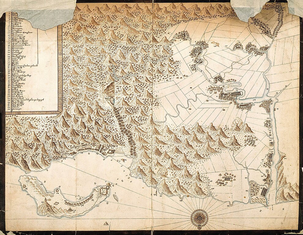
Nederlands: Titel catalogus Leupe (NA): Kaartje van Tamsuy en omleggende dorpen, zoo mede het eilandje Kelang.
Hoewel gerestaureerd is de kaart beschadigd waardoor een gedeelte van de verklaringen in de inzet verloren is gegaan. Notities verso: Deze kaart behoort in portefeuille 1654 no. V by eene Beschryving van het eiland Formosa en onderhoorigheden als Tamsay enz. / 598 e.English: According to the Leupe catalogue (NA), the original title reads: Kaartje van Tamsuy en omleggende dorpen, zoo mede het eilandje Kelang.
Although the map has been restored it has been damaged, as a result of which some of the notes in the insert have been lost. Notes on reverse: Deze kaart behoort in portefeuille 1654 no. V by eene Beschryving van het eiland Formosa en onderhoorigheden als Tamsay enz. / 598 e. |
|||||||||||||||||||||||
| Date | circa 1654 | |||||||||||||||||||||||
| Medium |
Nederlands: ingekleurde tekening op papier
English: coloured drawing on paper |
|||||||||||||||||||||||
| Dimensions | height: 51.5 cm (20.2 in); width: 41 cm (16.1 in) | |||||||||||||||||||||||
| Collection |
|
|||||||||||||||||||||||
| Accession number |
NL-HaNA_4.VEL_1127 (old number: VEL1127) |
|||||||||||||||||||||||
| Inscriptions |
-
|
|||||||||||||||||||||||
| Notes |
English: Subjects: key, compass / dial, fortification, chart / map / plan, bird's-eye view / elevation, elevation / bird's-eye view, building
Nederlands: Onderwerpen: legenda, kompas / windroos, vesting, plattegrond / kaart, vogelvlucht / opstand, opstand / vogelvlucht, gebouw
English: Post: this image is related to a VOC trading post called Chi-lung |
|||||||||||||||||||||||
| Source/Photographer |
|
|||||||||||||||||||||||
| Permission (Reusing this file) |
|
|||||||||||||||||||||||
| Other versions |
|
|||||||||||||||||||||||


| Object location | | View this and other nearby images on: OpenStreetMap |
|---|
File history
Click on a date/time to view the file as it appeared at that time.
| Date/Time | Thumbnail | Dimensions | User | Comment | |
|---|---|---|---|---|---|
| current | 16:45, 10 June 2014 | | 2,400 × 1,863 (1.1 MB) | HuskyBot (talk | contribs) | == {{int:filedesc}} == {{Artwork |title = {{nl|1=Kaartje van Tamsuy en Kelang}} {{en|1=Map of Tamsuy and Kelang}} |description = {{nl|1=Titel catalogus Leupe (NA): ''Kaartje van Tamsuy en omleggende dorpen, zoo... |
You cannot overwrite this file.
File usage on Commons
The following 7 pages use this file:
- File:400px-04141-2.jpg
- File:AMH-4602-NA Map of Tamsuy and Kelang.jpg
- File:Dutch Tamsui Map 1654.png
- File:Kaartje van Tamsuy en omleggende dorpen, zoo mede het eilandje Kelang.png
- File:Map of Danshui and Surrounding Areas, Including the Island of Jilong, 1654.jpg
- File:Old map of Taipei.jpg
- File:《Kaartje van Tamsuy en omleggende dorpen, zoo mede het eilandje Kelang》.jpg