File:AMH-4561-NA Map of the city of Palliacatta.jpg

Original file (8,914 × 6,319 pixels, file size: 6.68 MB, MIME type: image/jpeg)
Captions
Captions
Summary
[edit]Nederlands: Plattegrond van de stad Palliacatta
English: Map of the city of Palliacatta( |
||||||||||||||||||||||||||
|---|---|---|---|---|---|---|---|---|---|---|---|---|---|---|---|---|---|---|---|---|---|---|---|---|---|---|
| Author |
Nederlands: Isaac de Graaff (landmeter / kaartenmaker)
English: Isaac de Graaff (land surveyor / mapmaker) |
|||||||||||||||||||||||||
| Title |
Nederlands: Plattegrond van de stad Palliacatta
English: Map of the city of Palliacatta |
|||||||||||||||||||||||||
| Description |
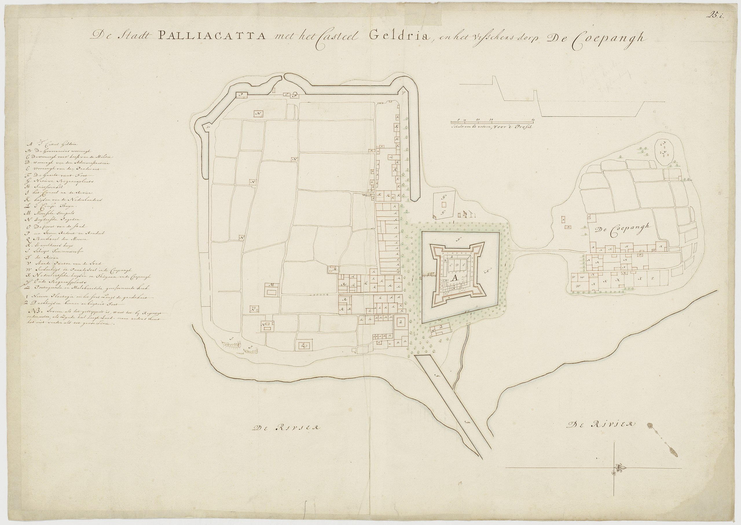
Nederlands: Titel catalogus Leupe (NA): Grondplan van de stadt Palliacatta, met het Casteel Geldria en het visschersdorp De Coepangh.
Legenda: A-Z; 1-3 Gerestaureerd, de randen zijn bijgeplakt. Rechts boven genummerd: 25.i. Notities verso: 54 [in potlood] / 589.English: According to the Leupe catalogue (NA), the original title reads: Grondplan van de stadt Palliacatta, met het Casteel Geldria en het visschersdorp De Coepangh.
Key: A-Z; 1-3 Restored, the edges have been neatened. Numbered top right: 25.i. Notes on reverse: 54 [in pencil] / 589. |
|||||||||||||||||||||||||
| Date | between 1690 and 1705 | |||||||||||||||||||||||||
| Medium |
Nederlands: ingekleurde tekening op papier
English: coloured drawing on paper |
|||||||||||||||||||||||||
| Dimensions | height: 75 cm (29.5 in); width: 53 cm (20.8 in) | |||||||||||||||||||||||||
| Collection |
|
|||||||||||||||||||||||||
| Accession number |
NL-HaNA_4.VEL_1089 (old number: VEL1089) |
|||||||||||||||||||||||||
| Inscriptions |
Grondplan van de stadt Palliacatta, met het Casteel Geldria en het visschersdorp De Coepangh
|
|||||||||||||||||||||||||
| Notes |
English: Subjects: key, fortification, chart / map / plan
Nederlands: Onderwerpen: legenda, vesting, plattegrond / kaart
English: Fort: this image is related to a VOC fort called Gelderland |
|||||||||||||||||||||||||
| Source/Photographer |
|
|||||||||||||||||||||||||
| Permission (Reusing this file) |
|
|||||||||||||||||||||||||

| Object location | | View this and other nearby images on: OpenStreetMap |
|---|
File history
Click on a date/time to view the file as it appeared at that time.
| Date/Time | Thumbnail | Dimensions | User | Comment | |
|---|---|---|---|---|---|
| current | 13:10, 29 September 2020 | | 8,914 × 6,319 (6.68 MB) | Fentener van Vlissingen (talk | contribs) | higher resolution |
| 16:37, 10 June 2014 |  | 2,400 × 1,662 (480 KB) | HuskyBot (talk | contribs) | == {{int:filedesc}} == {{Artwork |title = {{nl|1=Plattegrond van de stad Palliacatta}} {{en|1=Map of the city of Palliacatta}} |description = {{nl|1=Titel catalogus Leupe (NA): ''Grondplan van de stadt Palliaca... |
You cannot overwrite this file.
File usage on Commons
The following page uses this file:
File usage on other wikis
The following other wikis use this file:
- Usage on nl.wikipedia.org