File:AMH-4554-NA Map of Vyf Sinnen castle at Nagapatnam.jpg
Jump to navigation
Jump to search
Size of this preview: 800 × 569 pixels. Other resolutions: 320 × 227 pixels | 640 × 455 pixels | 1,024 × 728 pixels | 1,280 × 910 pixels | 2,400 × 1,706 pixels.
Original file (2,400 × 1,706 pixels, file size: 680 KB, MIME type: image/jpeg)
Captions
Captions
Add a one-line explanation of what this file represents
Summary
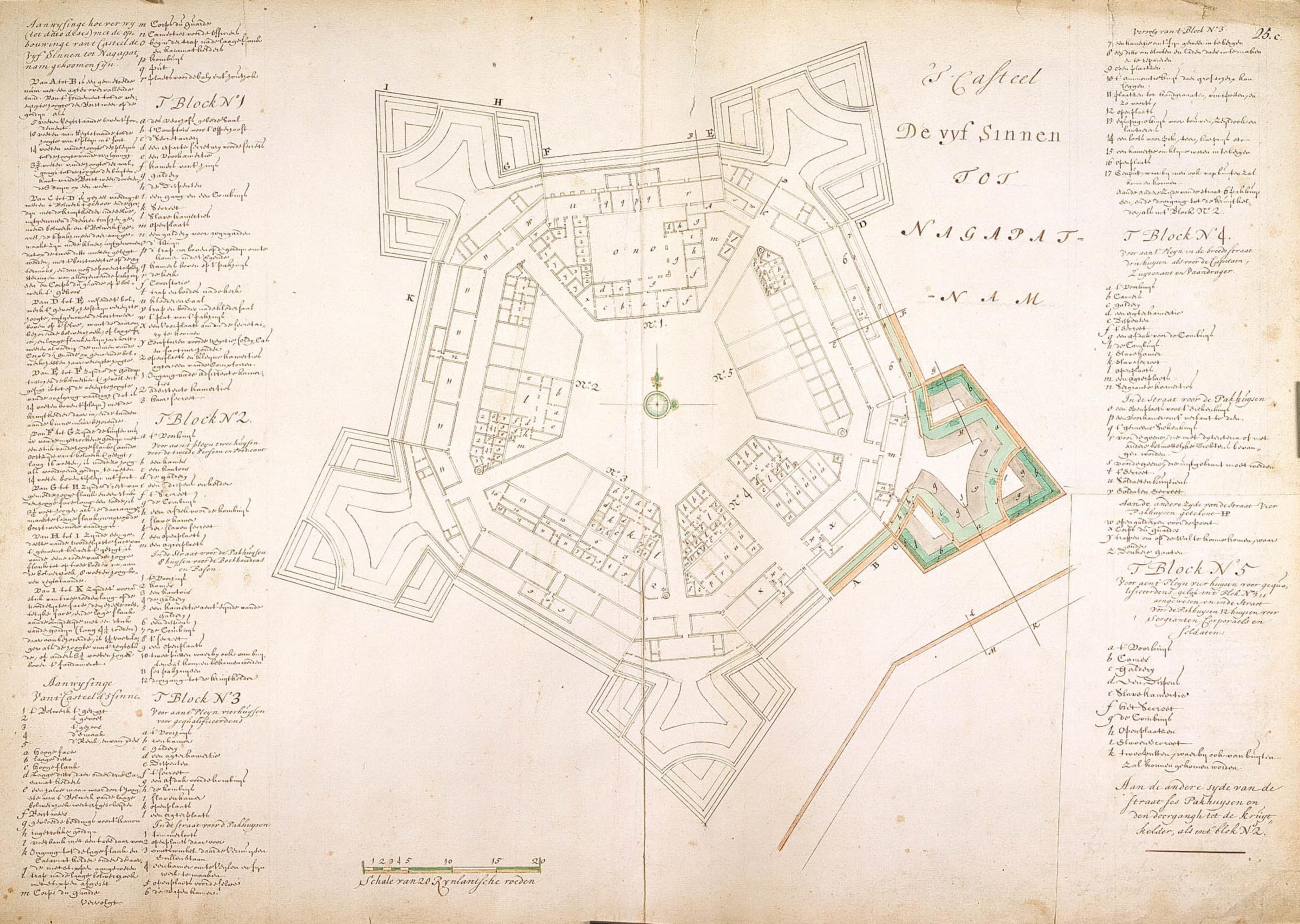
[edit]Nederlands: Plattegrond van kasteel de Vyf Sinnen te Nagapatnam
English: Map of Vyf Sinnen castle at Nagapatnam( |
||||||||||||||||||||||||||
|---|---|---|---|---|---|---|---|---|---|---|---|---|---|---|---|---|---|---|---|---|---|---|---|---|---|---|
| Author |
Nederlands: Isaac de Graaff (landmeter / kaartenmaker)
English: Isaac de Graaff (land surveyor / mapmaker) |
|||||||||||||||||||||||||
| Title |
Nederlands: Plattegrond van kasteel de Vyf Sinnen te Nagapatnam
English: Map of Vyf Sinnen castle at Nagapatnam |
|||||||||||||||||||||||||
| Description |
Nederlands: Titel catalogus Leupe (NA): Plan van 't Casteel de Vyf Sinnen, tot Nagapatnam.
Diverse legenda's.
English: According to the Leupe catalogue (NA), the original title reads: Plan van 't Casteel de Vyf Sinnen, tot Nagapatnam.
Various keys. |
|||||||||||||||||||||||||
| Date | between 1700 and 1800 | |||||||||||||||||||||||||
| Medium |
Nederlands: ingekleurde tekening op papier
English: coloured drawing on paper |
|||||||||||||||||||||||||
| Dimensions | height: 75 cm (29.5 in); width: 53 cm (20.8 in) | |||||||||||||||||||||||||
| Collection |
|
|||||||||||||||||||||||||
| Accession number |
NL-HaNA_4.VEL_1083 (old number: VEL1083) |
|||||||||||||||||||||||||
| Inscriptions |
'T Casteel De Vyf Sinnen tot Nagapatnam
|
|||||||||||||||||||||||||
| Notes |
English: Subjects: key, fortification, chart / map / plan
Nederlands: Onderwerpen: legenda, vesting, plattegrond / kaart
English: Fort: this image is related to a VOC fort called fort Vijf Sinnen |
|||||||||||||||||||||||||
| Source/Photographer |
|
|||||||||||||||||||||||||
| Permission (Reusing this file) |
|
|||||||||||||||||||||||||

| Object location | | View this and other nearby images on: OpenStreetMap |
|---|
File history
Click on a date/time to view the file as it appeared at that time.
| Date/Time | Thumbnail | Dimensions | User | Comment | |
|---|---|---|---|---|---|
| current | 16:36, 10 June 2014 | | 2,400 × 1,706 (680 KB) | HuskyBot (talk | contribs) | == {{int:filedesc}} == {{Artwork |title = {{nl|1=Plattegrond van kasteel de Vyf Sinnen te Nagapatnam}} {{en|1=Map of Vyf Sinnen castle at Nagapatnam}} |description = {{nl|1=Titel catalogus Leupe (NA): ''Plan va... |
You cannot overwrite this file.
File usage on Commons
The following 2 pages use this file:
File usage on other wikis
The following other wikis use this file:
- Usage on en.wikipedia.org
- Usage on nl.wikipedia.org
- Usage on ta.wikipedia.org
- Usage on www.wikidata.org