File:AMH-4528-NA Map and elevation of the main gate to Fort Oostenburg at Trinconomale.jpg
Jump to navigation
Jump to search

Size of this preview: 800 × 214 pixels. Other resolutions: 320 × 86 pixels | 640 × 171 pixels | 2,400 × 642 pixels.
Original file (2,400 × 642 pixels, file size: 173 KB, MIME type: image/jpeg)
Captions
Captions
Add a one-line explanation of what this file represents
Summary
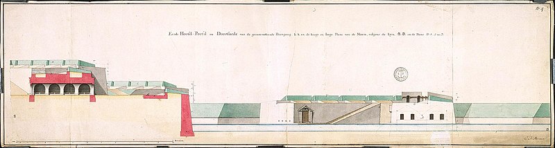
[edit]| Nederlands: Plattegrond en profiel van de hoofdpoort van fort Oostenburg te Trinconomale
English: Map and elevation of the main gate to Fort Oostenburg at Trinconomale ( |
||||||||||||||||||||||||
|---|---|---|---|---|---|---|---|---|---|---|---|---|---|---|---|---|---|---|---|---|---|---|---|---|
| Author |
Nederlands: Carl Friedrich Reimer (opdrachtgever)
English: Carl Friedrich Reimer (patron) |
|||||||||||||||||||||||
| Title |
Nederlands: Plattegrond en profiel van de hoofdpoort van fort Oostenburg te Trinconomale
English: Map and elevation of the main gate to Fort Oostenburg at Trinconomale |
|||||||||||||||||||||||
| Description |
Nederlands: Titel catalogus Leupe (NA): Profils, platte gronden enz. tot bovenstaande werken behoorende; van verschillende grootte en afmetingen.
Notities verso: Blauw etiket [ODG] nr: 23B; nr. 32; 1778 [jaartal?].
English: According to the Leupe catalogue (NA), the original title reads: Profils, platte gronden enz. tot bovenstaande werken behoorende; van verschillende grootte en afmetingen.
Notes on reverse: Blue label [ODG] nr: 23B; nr. 32; 1778 [year?]. |
|||||||||||||||||||||||
| Date | circa 1750 | |||||||||||||||||||||||
| Medium |
Nederlands: ingekleurde tekening op papier
English: coloured drawing on paper |
|||||||||||||||||||||||
| Dimensions | height: 92.5 cm (36.4 in); width: 25 cm (9.8 in) | |||||||||||||||||||||||
| Collection |
|
|||||||||||||||||||||||
| Accession number |
NL-HaNA_4.VEL_1035B (old number: VEL1035B) |
|||||||||||||||||||||||
| Inscriptions |
Eerste hoofprofil en doorsnede van gecasemateerde doorgang [...] flank van de Maan.
author: C.F. Reimer |
|||||||||||||||||||||||
| Notes |
English: Subjects: fortification, survey / view, cross-section / profile, gate
Nederlands: Onderwerpen: vesting, overzicht / aanzicht, doorsnede / profiel, poort
English: Fort: this image is related to a VOC fort called fort Oostenburgh |
|||||||||||||||||||||||
| Source/Photographer |
|
|||||||||||||||||||||||
| Permission (Reusing this file) |
|
|||||||||||||||||||||||

| Object location | | View this and other nearby images on: OpenStreetMap |
|---|
File history
Click on a date/time to view the file as it appeared at that time.
| Date/Time | Thumbnail | Dimensions | User | Comment | |
|---|---|---|---|---|---|
| current | 16:31, 10 June 2014 | 2,400 × 642 (173 KB) | HuskyBot (talk | contribs) | == {{int:filedesc}} == {{Artwork |title = {{nl|1=Plattegrond en profiel van de hoofdpoort van fort Oostenburg te Trinconomale}} {{en|1=Map and elevation of the main gate to Fort Oostenburg at Trinconomale}} |descrip... |
You cannot overwrite this file.
File usage on Commons
The following page uses this file: