File:AMH-2626-NA Ground plan of the new lodge to be built at Brotchia.jpg
Jump to navigation
Jump to search

Size of this preview: 514 × 599 pixels. Other resolutions: 206 × 240 pixels | 412 × 480 pixels | 659 × 768 pixels | 878 × 1,024 pixels | 2,059 × 2,400 pixels.
Original file (2,059 × 2,400 pixels, file size: 800 KB, MIME type: image/jpeg)
Captions
Captions
Add a one-line explanation of what this file represents
Summary
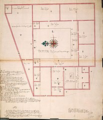
[edit]Nederlands: Plattegrond voor de nieuw te bouwen loge te Brotchia
English: Ground plan of the new lodge to be built at Brotchia( |
||||||||||||||||||||||||
|---|---|---|---|---|---|---|---|---|---|---|---|---|---|---|---|---|---|---|---|---|---|---|---|---|
| Author |
Nederlands: Anoniem / Anonymous
English: Anoniem / Anonymous |
|||||||||||||||||||||||
| Title |
Nederlands: Plattegrond voor de nieuw te bouwen loge te Brotchia
English: Ground plan of the new lodge to be built at Brotchia |
|||||||||||||||||||||||
| Description |
Nederlands: Titel catalogus Leupe: Platte grond voor de nieuw te bouwen Logie te Brotchia.
Notities verso: Nr. 1; 499g potlood; (fol.) nr. 269; Q 1. Legenda: A-XEnglish: According to the Leupe catalogue, the original title reads: Platte grond voor de nieuw te bouwen Logie te Brotchia.
Notes on reverse: Nr. 1; 499g potlood; (fol.) nr. 269; Q 1. Key: A-X |
|||||||||||||||||||||||
| Date | circa 1700 | |||||||||||||||||||||||
| Medium |
Nederlands: ingekleurde tekening op papier
English: coloured drawing on paper |
|||||||||||||||||||||||
| Dimensions | height: 52 cm (20.4 in); width: 59 cm (23.2 in) | |||||||||||||||||||||||
| Collection |
|
|||||||||||||||||||||||
| Accession number |
NL-HaNA_4.VEL_876A (old number: VEL0876A) |
|||||||||||||||||||||||
| Inscriptions |
-
|
|||||||||||||||||||||||
| Notes |
English: Subjects: chart / map / plan, house, building, warehouse, compass / dial, key
Nederlands: Onderwerpen: plattegrond / kaart, huis / woonhuis, gebouw, pakhuis, kompas / windroos, legenda
English: Post: this image is related to a VOC trading post called Bharuch |
|||||||||||||||||||||||
| Source/Photographer |
|
|||||||||||||||||||||||
| Permission (Reusing this file) |
|
|||||||||||||||||||||||

| Object location | | View this and other nearby images on: OpenStreetMap |
|---|
File history
Click on a date/time to view the file as it appeared at that time.
| Date/Time | Thumbnail | Dimensions | User | Comment | |
|---|---|---|---|---|---|
| current | 16:11, 10 June 2014 | | 2,059 × 2,400 (800 KB) | HuskyBot (talk | contribs) | == {{int:filedesc}} == {{Artwork |title = {{nl|1=Plattegrond voor de nieuw te bouwen loge te Brotchia}} {{en|1=Ground plan of the new lodge to be built at Brotchia}} |description = {{nl|1=Titel catalogus Leupe:... |
You cannot overwrite this file.
File usage on Commons
The following page uses this file: