File:AMH-2525-NA Ground plan of a water fort near the river bank of Kali Besar in Batavia.jpg
Original file (2,400 × 2,156 pixels, file size: 586 KB, MIME type: image/jpeg)
Captions
Captions
Summary
[edit]| Author | ||||||||||||||||||||||||
| Title |
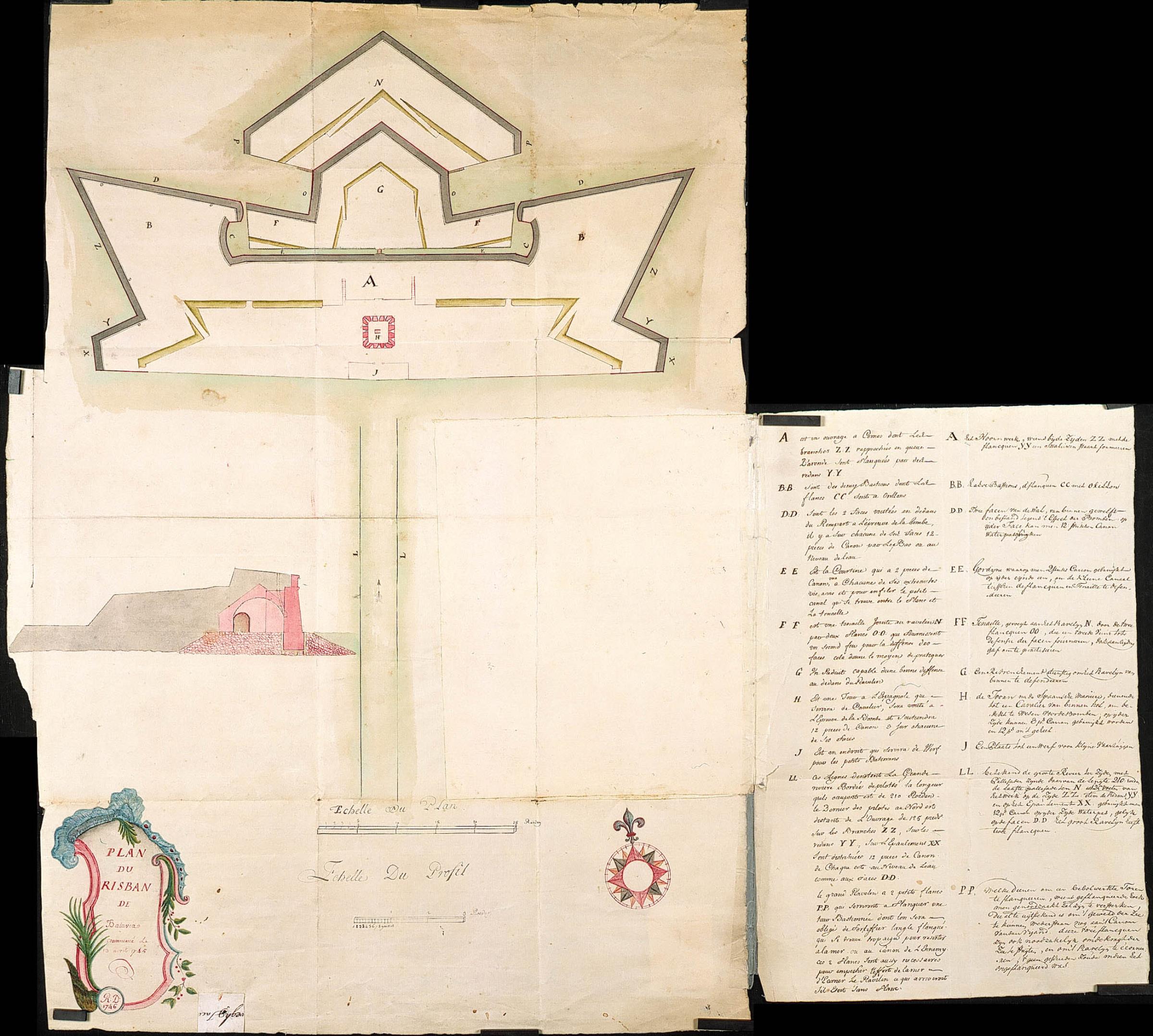
Nederlands: Plan voor de nieuwe waterpas aan de rivier van Batavia
English: Ground plan of a water fort near the river bank of Kali Besar in Batavia
Bahasa Indonesia: Denah pembangunan benteng air di tepi sungai Kali Besar di Batavia (Jakarta) |
|||||||||||||||||||||||
| Description |
Nederlands: Titel catalogus Leupe (NA): Plans voor het Nieuwe waterpas op de bank voor de Groote Rivier.
Notities verso: Plan van het nieuwpas op de bank van de grote rivier te Batavia. Maakt deel uit van serie VEL0383-0419; Deze kaarten hebben betrekking op de peilingen op de bank voor de rivier. Tussen 1708 en 1742 werden deze peilingen twee maal per jaar verricht. Legenda: A-PP Linksonder de term Risban, ofwel waterfort.English: According to catalogue Leupe (NA), the original title reads: Plans voor het Nieuwe waterpas op de bank voor de Groote Rivier.
Notes on reverse: Plan van het nieuwpas op de bank van de grote rivier te Batavia. Part of the VEL0383-0419 series. These charts relate to the depth measurements of the river bank. Between 1708 and 1742 these measurements were taken twice a year. Key: A-PP Lower left the term Risban, or water fort.Bahasa Indonesia: Menurut katalog Leupe (NA), judul aslinya berbunyi: Plans voor het Nieuwe waterpas op de bank voor de Groote Rivier.
Catatan di baliknya: Plan van het nieuwpas op de bank van de grote rivier te Batavia. Bagian dari seri VEL0383-0419. Grafik ini berhubungan dengan pengukuran kedalaman tepi sungai. Antara 1708 dan 1742 pengukuran ini dilakukan dua kali setahun. Kunci: A-PP Kiri bawah tertulis istilah Risban, atau benteng air. |
|||||||||||||||||||||||
| Date | 1746 | |||||||||||||||||||||||
| Medium |
Nederlands: ingekleurde tekening op papier
English: coloured drawing on paper |
|||||||||||||||||||||||
| Dimensions | height: 827 mm (32.55 in); width: 756 mm (29.76 in) | |||||||||||||||||||||||
| Collection |
|
|||||||||||||||||||||||
| Accession number |
NL-HaNA_4.VEL_386 (old number: VEL0386) |
|||||||||||||||||||||||
| Inscriptions |
Plan du Risban du Batavia
author: R.D. |
|||||||||||||||||||||||
| Notes |
English: Subjects: chart / map / plan, fortification, anchorage / pier / harbour, banderole / cartouche / ornamentation, compass / dial, key
Nederlands: Onderwerpen: plattegrond / kaart, vesting, rede / haven / pier, banderol / cartouche / versiering, kompas / windroos, legenda
English: Post: this image is related to a VOC trading post called Jakarta |
|||||||||||||||||||||||
| Source/Photographer |
|
|||||||||||||||||||||||
| Permission (Reusing this file) |
|
|||||||||||||||||||||||

| Object location | | View this and other nearby images on: OpenStreetMap |
|---|
File history
Click on a date/time to view the file as it appeared at that time.
| Date/Time | Thumbnail | Dimensions | User | Comment | |
|---|---|---|---|---|---|
| current | 15:51, 10 June 2014 | | 2,400 × 2,156 (586 KB) | HuskyBot (talk | contribs) | == {{int:filedesc}} == {{Artwork |title = {{nl|1=Plan voor de nieuwe waterpas aan de rivier van Batavia}} {{en|1=Ground plan of a water fort near the river bank of Kali Besar in Batavia}} |description = {{nl|1=... |
You cannot overwrite this file.
File usage on Commons
The following page uses this file: