File:ACW Chattanooga2Carolinas.png
Jump to navigation
Jump to search
Size of this preview: 800 × 426 pixels. Other resolutions: 320 × 170 pixels | 640 × 341 pixels | 1,024 × 545 pixels | 1,881 × 1,002 pixels.
Original file (1,881 × 1,002 pixels, file size: 429 KB, MIME type: image/png)
Captions
Captions
Add a one-line explanation of what this file represents
Summary
[edit]| Description |
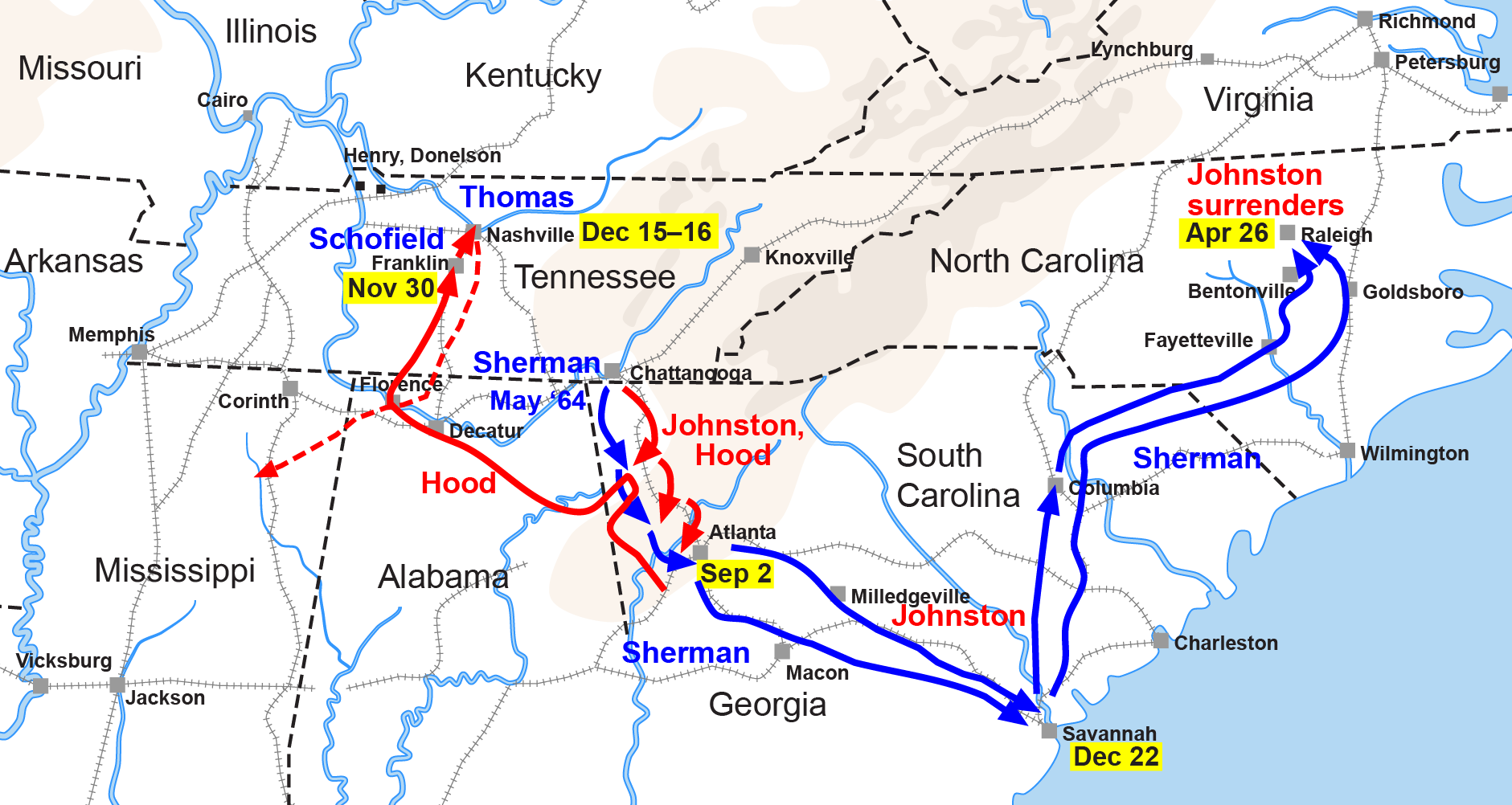
English: Map of the Western Theater of the American Civil War, actions from Chattanooga to the Carolinas. |
| Date | |
| Source | Drawn by Hal Jespersen in Adobe Illustrator CS5. Graphic source file is available at http://www.posix.com/CWmaps/ |
| Author | Hlj at English Wikipedia |
| Other versions |
|


Licensing
[edit]
This file is licensed under the Creative Commons Attribution 3.0 Unported license.
Attribution: Map by Hal Jespersen, www.posix.com/CW
- You are free:
- to share – to copy, distribute and transmit the work
- to remix – to adapt the work
- Under the following conditions:
- attribution – You must give appropriate credit, provide a link to the license, and indicate if changes were made. You may do so in any reasonable manner, but not in any way that suggests the licensor endorses you or your use.
Original upload log
[edit]
Transferred from it.wikipedia to Commons by MaEr.
The original description page was here. All following user names refer to it.wikipedia.
- 2006-10-06 17:12 Starlight 1566×773×??? (316548 bytes) Map of the Western Theater of the American Civil War, actions from Chattanooga to the Carolinas. Drawn by Hal Jespersen in Macromedia Freehand. Graphic source file is available at http://www.posix.com/CWmaps/ {{PD}}
The original description page was here. All following user names refer to en.wikipedia.
- 2006-03-31 00:30 Hlj 1566×773× (316548 bytes) Map of the [[Western Theater of the American Civil War]], actions from Chattanooga to the Carolinas. Drawn by Hal Jespersen in Macromedia Freehand. Graphic source file is available at http://www.posix.com/CWmaps/ {{PD-release}}
File history
Click on a date/time to view the file as it appeared at that time.
| Date/Time | Thumbnail | Dimensions | User | Comment | |
|---|---|---|---|---|---|
| current | 22:35, 24 March 2011 | | 1,881 × 1,002 (429 KB) | Hlj (talk | contribs) | Update to new graphical style for rivers. Same license. |
| 05:34, 6 February 2009 |  | 1,862 × 992 (309 KB) | Hlj (talk | contribs) | {{Information |Description=Map of Sherman's operations from Chattanooga through the Carolinas of the American Civil War. (Minor updates from previous version; new license.) Drawn in Adobe Illustrator CS3 by Hal Jespersen. Graphic source file is availa | |
| 11:50, 14 September 2008 |  | 1,566 × 773 (309 KB) | MaEr (talk | contribs) | {{Information |Description={{en|Map of the Western Theater of the American Civil War, actions from Chattanooga to the Carolinas. Drawn by Hal Jespersen in Macromedia Freehand. Graphic source file is available at http://www.posix.com/CWmaps/}} |Source=Tran |
You cannot overwrite this file.
File usage on Commons
The following 5 pages use this file:
File usage on other wikis
The following other wikis use this file:
- Usage on da.wikipedia.org
- Usage on en.wikipedia.org
- Usage on fr.wikipedia.org
- Usage on it.wikipedia.org
- Usage on ja.wikipedia.org
- Usage on ru.wikipedia.org
- Usage on uk.wikipedia.org