File:ACK Airport Diagram.svg
Jump to navigation
Jump to search

Size of this PNG preview of this SVG file: 390 × 599 pixels. Other resolutions: 156 × 240 pixels | 313 × 480 pixels | 500 × 768 pixels | 667 × 1,024 pixels | 1,334 × 2,048 pixels | 516 × 792 pixels.
Original file (SVG file, nominally 516 × 792 pixels, file size: 458 KB)
Captions
Captions
Add a one-line explanation of what this file represents
Summary
[edit]
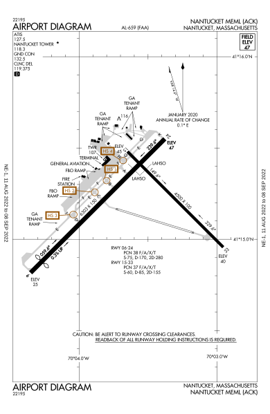
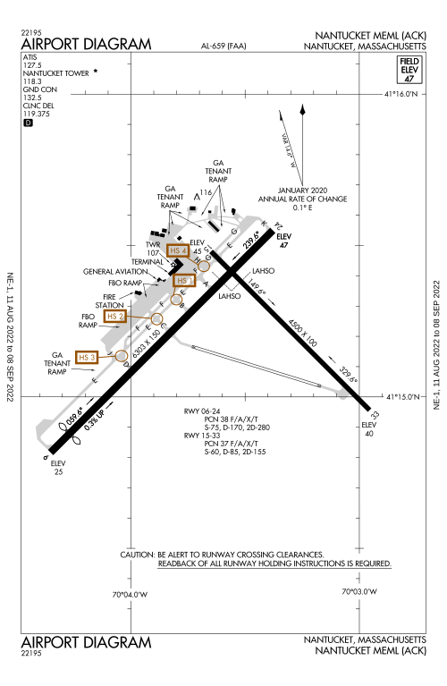
| Description |
English: FAA Airport Diagram of airport: ACK |
| Date | |
| Source |
FAA Airport Diagrams; note that these change every 28 days. Taken from PDF on FAA site and converted to SVG using en:Wikipedia:How to draw SVG circuits using Xcircuit. |
| Author | Produced by the National Aeronautical Charting Office (NACO), a department of the United States en:Federal Aviation Administration. |
| Camera location | | View this and other nearby images on: OpenStreetMap |
|---|
W3C-validity not checked.
Licensing
[edit]
This image or file is a work of a Federal Aviation Administration employee, taken or made as part of that person's official duties. As a work of the U.S. federal government, the image is in the public domain in the United States.
|
 |
File history
Click on a date/time to view the file as it appeared at that time.
| Date/Time | Thumbnail | Dimensions | User | Comment | |
|---|---|---|---|---|---|
| current | 13:56, 5 August 2022 | | 516 × 792 (458 KB) | KDTW Flyer (talk | contribs) | update to newest version, as RW 12/30 has now been decommissioned |
| 23:10, 9 January 2017 |  | 378 × 548 (504 KB) | Grendelkhan (talk | contribs) | SVG version of FAA's PDF diagram. |
You cannot overwrite this file.
File usage on Commons
The following 6 pages use this file:
- User:Chumwa/OgreBot/Potential transport maps/2017 January 1-10
- User:Chumwa/OgreBot/Transport Maps/2017 January 1-10
- User:Chumwa/OgreBot/Transport Maps/2022 August 1-10
- User:Chumwa/OgreBot/Travel and communication maps/2017 January 1-10
- Commons:WikiProject Aviation/recent uploads/2017 January 9
- Category:Nantucket Memorial Airport
File usage on other wikis
The following other wikis use this file:
- Usage on en.wikipedia.org
- Usage on ur.wikipedia.org
- Usage on www.wikidata.org