File:88c007 Upper entrance bay of Kentucky River Lock No. 3 (26171286134).jpg
Original file (3,636 × 2,400 pixels, file size: 3.24 MB, MIME type: image/jpeg)
Captions
Captions
Summary
[edit].jpg&action=edit§ion=1)
| Description |
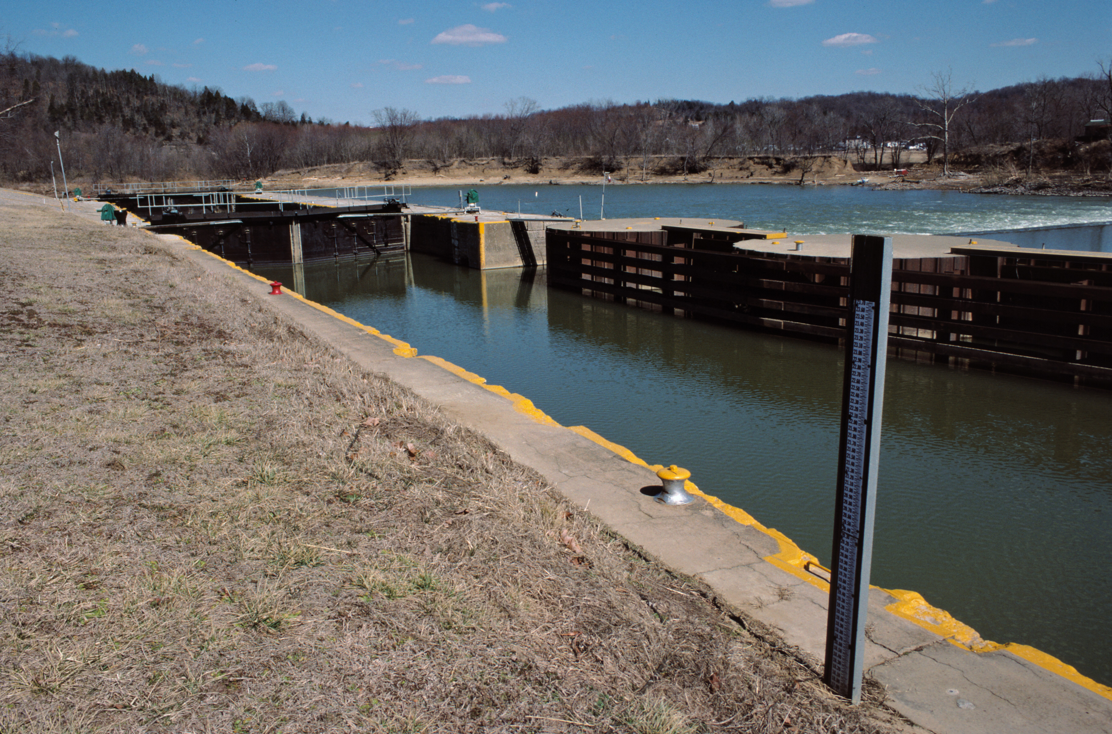
English: Looking NNE from upper entrance bay of Lock No. 3
This lock is 145 feet long and 38 feet wide, with about a 13 foot lift. I would guess that the zero point of the gauge at right is the elevation of the upper sill of the lock. Across the river is Cedar Creek Beach, in Owen County. From Kentucky River Authority: Lock and Dam 3 were built from 1836-1842 and support a twenty three mile long pool of water. The original dam was a timber crib structure, consisting of an outside frame of timbers filled with dirt and rock, and the original lock was stone masonry. The structures are located forty two miles above the mouth of the Ohio River. Lock 3 was shut down in 2007 because of mechanical and structural problems. History: 1836-1842 Original construction of lock and dam 1882 Dam is rebuilt by the Corps of Engineers Early 1890’s Concrete cap is added to the top of the timber crib dam (one drawing shows about two thirds of the timber crib dam is capped with concrete by 1911, with the rest still protected by wooden planks) Approximately 1908 Concrete wall is constructed next to the abutment, opposite of the lock, running upstream approximately 70 feet 1941 Surface repairs to cracks and holes in the concrete cap are made 1977 New concrete is added to the crest of the dam, Surface repairs are made to cracks in the existing concrete cap on the dam, sheet pilling is added to the front of the dam 2005 Abutment, opposite of the lock, is repaired with rock armoring See also Kentucky River navigation charts (2011 version, 5 MB PDF) and Kentucky River navigation charts (1972 version, 19 MB PDF) and Kentucky River Development: The Commonwealth’s Waterway by Leland R. Johnson and Charles E. Parrish (1999, 9 MB PDF) _____________________________ Kentucky River mile 42 Gest, Kentucky (in Henry County) Mar. 1988 file # 88c007 35 mm Kodachrome Plustek OpticFilm 7600i Siverfast 8 Picture Window 6 some sharpening (unsharp mask) JPEG quality 95 |
| Date | |
| Source | 88c007: Upper entrance bay of Kentucky River Lock No. 3 |
| Author | William Alden from Louisville, Kentucky, USA |
| Camera location | | View this and other nearby images on: OpenStreetMap |
|---|
.jpg¶ms=038.417313_N_-084.880201_E_globe:Earth_type:camera_source:Flickr_&language=en)
Licensing
[edit].jpg&action=edit§ion=2)
- You are free:
- to share – to copy, distribute and transmit the work
- to remix – to adapt the work
- Under the following conditions:
- attribution – You must give appropriate credit, provide a link to the license, and indicate if changes were made. You may do so in any reasonable manner, but not in any way that suggests the licensor endorses you or your use.
- share alike – If you remix, transform, or build upon the material, you must distribute your contributions under the same or compatible license as the original.
| This image was originally posted to Flickr by Bill Alden at https://flickr.com/photos/70020260@N04/26171286134 (archive). It was reviewed on 27 November 2019 by FlickreviewR 2 and was confirmed to be licensed under the terms of the cc-by-sa-2.0. |
File history
Click on a date/time to view the file as it appeared at that time.
| Date/Time | Thumbnail | Dimensions | User | Comment | |
|---|---|---|---|---|---|
| current | 22:27, 27 November 2019 | | 3,636 × 2,400 (3.24 MB) | Ser Amantio di Nicolao (talk | contribs) | Transferred from Flickr via #flickr2commons |
You cannot overwrite this file.
File usage on Commons
The following page uses this file:
.jpg&oldid=890814762)