File:87h107 Bayou Boeuf with tank barges at Clark Bridge (7275220742).jpg

Original file (2,000 × 2,038 pixels, file size: 1.03 MB, MIME type: image/jpeg)
Captions
Captions
Summary
[edit].jpg&action=edit§ion=1)
| Description |
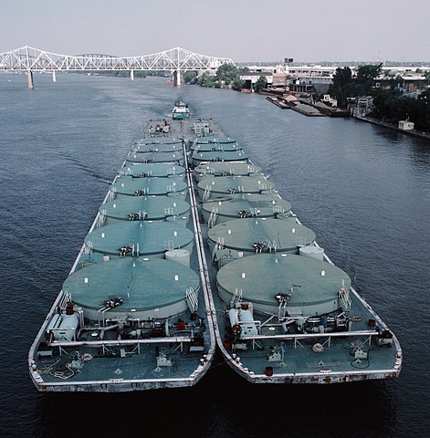
English: Looking E (upstream) from Clark Bridge.
Towboat "Bayou Boeuf" (doc. # 264736) downbound with tank barges. Port of Louisville Terminal and Martin Marietta sand yard, at right. Twin screw towboat "Bayou Boeuf" (doc. # 264736, length 132 feet, breadth 30 feet, Alco 16V251B diesels, 4600 hp. [repowered in 2006 with Cat 3516 diesels, 4000 hp.]) was built in 1953 by Nashville Bridge Co., Nashville, Tennessee. Owned by Chotin Transportation, New Orleans, it was originally named "Jos. Chotin". In 1968, the boat was sold to Oil Transport Co., New Orleans, and renamed "Bayou Boeuf". In 1994, the boat was sold to Tug Cynthia, Inc., and renamed "Cynthia". As of early 2013, the boat was owned by Pasentine Family Enterprises, Mandeville, Louisiana, and operated by Florida Marine Transporters, Inc., Mandeville. In 2015, the boat was sold to Whitetail Vessel Co. LLC, Paducah, Kentucky, and operated by Tennessee Valley Towing, Paducah. In 2017, the boat was renamed "Debbie Graham". Still operating in 2018. . The two tank barges at the head of the tow are somewhat unusual in that the 8 cylindrical tanks on each barge are visible above the deck. On the starboard bow is the heater for the thermal oil which circulates through coils within the tanks. This keeps liquid cargo like asphalt or crude oil thin enough to be pumped out at the destination. Ohio River mile 604. Louisville, Kentucky. August 1987. File # 87h107. . 35 mm Kodachrome slide. scanned with Plustek OpticFilm 7600i and Silverfast 8. edited with Picture Window 4 |
| Date | |
| Source | 87h107: Bayou Boeuf with tank barges at Clark Bridge |
| Author | William Alden from Louisville, Kentucky, USA |
| Camera location | | View this and other nearby images on: OpenStreetMap |
|---|
.jpg¶ms=038.260777_N_-085.752024_E_globe:Earth_type:camera_source:Flickr_&language=en)
Licensing
[edit].jpg&action=edit§ion=2)
- You are free:
- to share – to copy, distribute and transmit the work
- to remix – to adapt the work
- Under the following conditions:
- attribution – You must give appropriate credit, provide a link to the license, and indicate if changes were made. You may do so in any reasonable manner, but not in any way that suggests the licensor endorses you or your use.
- share alike – If you remix, transform, or build upon the material, you must distribute your contributions under the same or compatible license as the original.
| This image was originally posted to Flickr by Bill Alden at https://flickr.com/photos/70020260@N04/7275220742 (archive). It was reviewed on 27 November 2019 by FlickreviewR 2 and was confirmed to be licensed under the terms of the cc-by-sa-2.0. |
File history
Click on a date/time to view the file as it appeared at that time.
| Date/Time | Thumbnail | Dimensions | User | Comment | |
|---|---|---|---|---|---|
| current | 22:08, 27 November 2019 | | 2,000 × 2,038 (1.03 MB) | Ser Amantio di Nicolao (talk | contribs) | Transferred from Flickr via #flickr2commons |
You cannot overwrite this file.
File usage on Commons
The following page uses this file:
.jpg&oldid=900768601)