File:66543 Dosthill 110523 - 52896134092.jpg
Jump to navigation
Jump to search

Size of this preview: 800 × 508 pixels. Other resolutions: 320 × 203 pixels | 640 × 407 pixels | 1,024 × 651 pixels | 1,280 × 813 pixels | 3,137 × 1,993 pixels.
Original file (3,137 × 1,993 pixels, file size: 1.62 MB, MIME type: image/jpeg)
Captions
Captions
Add a one-line explanation of what this file represents
Summary
[edit]
| Description |
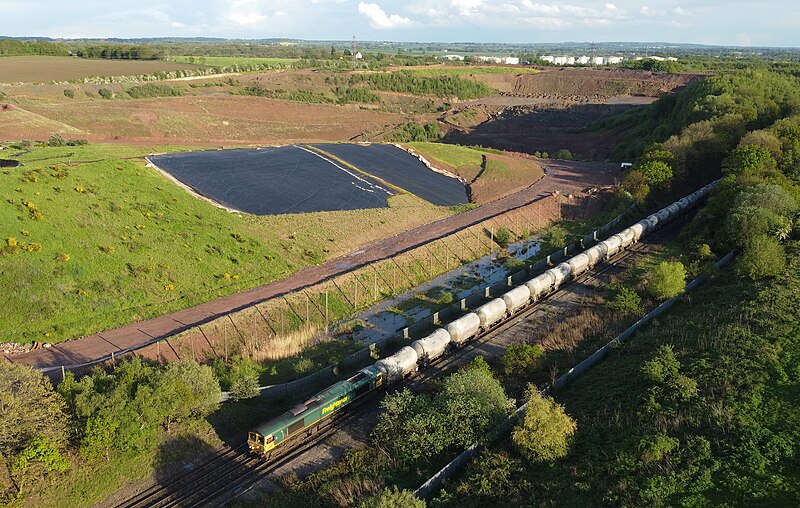
English: Dotshill is a landfill site with two overbridges that lies between Wilnecote and Kingsbury Junction on the NE-SW Mainline.
Heavy freight action in the form of 66 543 on the Bescot-Earles Sidings (Hope) discharged cement tanks. These are 4K frame captures from the drone. Drone video footage here youtu.be/pYDN0Qm820U |
| Date | |
| Source | https://www.flickr.com/photos/58415659@N00/52896134092/ |
| Author | kitmasterbloke |
| Camera location | | View this and other nearby images on: OpenStreetMap |
|---|
Licensing
[edit]
This file is licensed under the Creative Commons Attribution 2.0 Generic license.
- You are free:
- to share – to copy, distribute and transmit the work
- to remix – to adapt the work
- Under the following conditions:
- attribution – You must give appropriate credit, provide a link to the license, and indicate if changes were made. You may do so in any reasonable manner, but not in any way that suggests the licensor endorses you or your use.
| This image was originally posted to Flickr by kitmasterbloke at https://flickr.com/photos/58415659@N00/52896134092. It was reviewed on 14 January 2024 by FlickreviewR 2 and was confirmed to be licensed under the terms of the cc-by-2.0. |
File history
Click on a date/time to view the file as it appeared at that time.
| Date/Time | Thumbnail | Dimensions | User | Comment | |
|---|---|---|---|---|---|
| current | 11:03, 14 January 2024 | | 3,137 × 1,993 (1.62 MB) | Oxyman (talk | contribs) | Uploaded a work by kitmasterbloke from https://www.flickr.com/photos/58415659@N00/52896134092/ with UploadWizard |
You cannot overwrite this file.
File usage on Commons
The following page uses this file: