File:5539Calauan Poblacion Victoria Road 40.jpg
Jump to navigation
Jump to search

Size of this preview: 800 × 600 pixels. Other resolutions: 320 × 240 pixels | 640 × 480 pixels | 1,024 × 768 pixels | 1,280 × 960 pixels | 2,560 × 1,920 pixels | 4,608 × 3,456 pixels.
Original file (4,608 × 3,456 pixels, file size: 5.65 MB, MIME type: image/jpeg)
Captions
Captions
Calauan Poblacion-Victoria Road
Summary
[edit]
| Description |
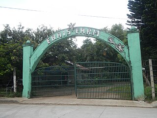
English: Calauan Poblacion-Victoria Road (Silangan-Lamot 1-Lamot 2-Santo Tomas-Dayap, Calauan & Masapang, Victoria) from Victoria (Masapang) Duck Junction Calauan - Victoria Road Calauan-Victoria Road Erais Farm Site of Eileen Sarmenta and Allan Gomez murder (Sitio Paputok, Kilometro 74, Mabacan, Imok, Balayhangin & Erais Farm, Santo Tomas & Lamot 2, Calauan, Laguna) Eileen Sarmenta and Allan Gomez murder Antonio Sanchez (politician) People vs. Antonio Sanchez, et al xxx"'The next destination was a sugarcane field in Sitio Paputok, Kilometro 74 of Barangay Mabacan. It was here that Luis announced that it’s time for the group to feast on Eileen (the exact words of Luis were “Turbohin na rin natin ang tinurbo ni Boss”)." xxx " Both vehicles then headed for Erais Farm situated in Barangay Curba, owned by the Mayor." xxx "The next destination was a sugarcane field in Sitio Paputok, Kilometro 74 of Barangay Mabacan." 'xxx a dead female loaded inside a Tamaraw van was found in Barangay Mabacan." " a card gambler was able to retrieve a pair of white shorts lying near the national highway in Barangay Balayhangin. In the morning of June 30, 1993, the Mayor, with some companions, jogged towards the direction of Barangay Mabacan and at the same time inquired from residents whether they noticed anything unusual on the night of June 28, 1993. A certain “Mang Torio” told the Mayor that he found a pair of “maong” pants lying at the side of the road but left if there. After inspecting the dirty “maong” pants, the Mayor instructed Mang Torio to keep the pants as the former will send someone back to pick it up." Km. 74 Brgy. Balayhangin Calauan Laguna 14°7'53"N 121°18'44"E along Category:Calauan Poblacion-Victoria Road Barangay Balayhangin, Calauan, Laguna 14.1298, 121.3164 Calauan,_Laguna and List of barangays in Laguna (province) Barangay Mabacan, Calauan, Laguna 14.1344, 121.2885 Calauan,_Laguna and Barangay and Erais Farm 30-hectare farm in Santo Tomas, Calauan, Laguna 14.1711, 121.3367 Calauan,_Laguna along Bay–Calauan–San Pablo Roadfrom Calamba–Los Baños Expressway to Calamba–Pagsanjan Road surrounded by Bay River Philippine highway network (Note: Judge Florentino Floro, the owner, to repeat, Donor Florentino Floro of all these photos hereby donate gratuitously, freely and unconditionally Judge Floro all these photos to and for Wikimedia Commons, exclusively, for public use of the public domain, and again without any condition whatsoever). |
| Date | |
| Source | Own work |
| Author | Judgefloro |
| Camera location | | View this and other nearby images on: OpenStreetMap |
|---|
Lamot 2, Calauan, Laguna 14.1582, 121.3446
Licensing
[edit]
I, the copyright holder of this work, hereby publish it under the following license:
| This file is made available under the Creative Commons CC0 1.0 Universal Public Domain Dedication. | |
| The person who associated a work with this deed has dedicated the work to the public domain by waiving all of their rights to the work worldwide under copyright law, including all related and neighboring rights, to the extent allowed by law. You can copy, modify, distribute and perform the work, even for commercial purposes, all without asking permission.
|
File history
Click on a date/time to view the file as it appeared at that time.
| Date/Time | Thumbnail | Dimensions | User | Comment | |
|---|---|---|---|---|---|
| current | 05:28, 19 August 2019 | | 4,608 × 3,456 (5.65 MB) | Judgefloro (talk | contribs) | User created page with UploadWizard |
You cannot overwrite this file.
File usage on Commons
There are no pages that use this file.
File usage on other wikis
The following other wikis use this file:
- Usage on en.wikipedia.org