File:470519 battleship Haruna.jpg
Jump to navigation
Jump to search

Size of this preview: 600 × 600 pixels. Other resolutions: 240 × 240 pixels | 480 × 480 pixels | 768 × 768 pixels | 1,025 × 1,024 pixels | 1,812 × 1,811 pixels.
Original file (1,812 × 1,811 pixels, file size: 2.54 MB, MIME type: image/jpeg)
Captions
Captions
Add a one-line explanation of what this file represents
Summary
[edit]
| Description |
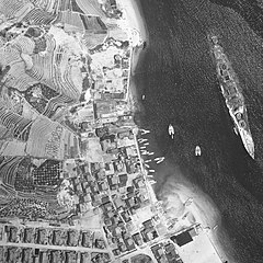
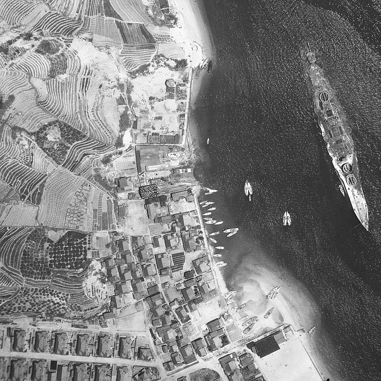
English: The hull of the battleship Haruna that settles on the coast of Etajima-cho Koyo, Etajima-shi.
日本語: 江田島市江田島町小用沿岸に着底する戦艦榛名の船体。米軍撮影の空中写真USA-M307-48を使用。 |
| Date | |
| Source | 国土情報ウェブマッピングシステム |
| Author | 米軍 |
| Camera location | | View this and other nearby images on: OpenStreetMap |
|---|
Licensing
[edit]

|
The copyright holder of this file, the Ministry of Land, Infrastructure, Transport and Tourism of Japan, allows anyone to use it for any purpose, provided that the copyright holder is properly attributed. Redistribution, derivative work, commercial use, and all other use is permitted. |
Attribution:
Copyright © National Land Image Information (Color Aerial Photographs), Ministry of Land, Infrastructure, Transport and Tourism
|
 |
This image is copyrighted by the Ministry of Land, Infrastructure, Transport and Tourism of Japan. For terms of use, see the stipulation to use of National Land Information (in Japanese) and message from MLIT (in Japanese and English). When you display this image on an article, include the following phrase in the description: "Made based on National Land Image Information (Color Aerial Photographs), Ministry of Land, Infrastructure, Transport and Tourism".
|
File history
Click on a date/time to view the file as it appeared at that time.
| Date/Time | Thumbnail | Dimensions | User | Comment | |
|---|---|---|---|---|---|
| current | 12:16, 30 June 2020 | | 1,812 × 1,811 (2.54 MB) | 名古屋太郎 (talk | contribs) | Exifデータ修正。 |
| 12:12, 30 June 2020 |  | 1,812 × 1,811 (2.54 MB) | 名古屋太郎 (talk | contribs) | {{Information |description ={{en|1=The hull of the battleship Haruna that settles on the coast of Etajima-cho Koyo, Etajima-shi.}} {{ja|1=江田島市江田島町小用沿岸に着底する戦艦榛名の船体。米軍撮影の空中写真USA-M307-48を使用。}} |date =1947-05-19 |source =国土情報ウェブマッピングシステム |author =米軍 }} Category:Haruna (ship, 1915) Category:Port of Koyo, Etajima |
You cannot overwrite this file.
File usage on Commons
There are no pages that use this file.
File usage on other wikis
The following other wikis use this file:
- Usage on en.wikipedia.org
- Usage on ja.wikipedia.org