File:42924 2195channelsismenius.jpg

Original file (1,228 × 2,048 pixels, file size: 670 KB, MIME type: image/jpeg)
Captions
Captions
Summary
[edit]
| Description |
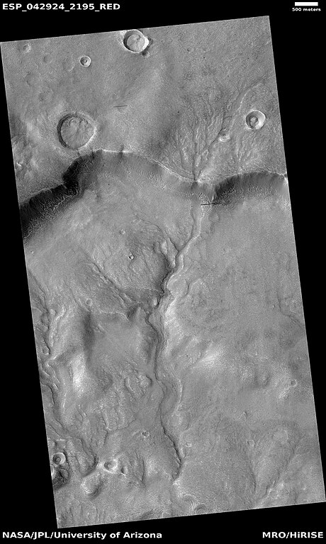
English: Here is the caption that NASA wrote for this image: Early in Martian history, liquid water energetically carved the surface, forming channel systems that look remarkably similar to river valleys and drainage networks on Earth. Exactly how these channels formed—by rainfall, snowmelt, or seepage from underground springs—is often debated.
The answer has important ramifications about the early Martian climate. Clues about the source of the water may indicate the shape, layout, and scale of the various tributaries in a channel system. Our image shows an example of just such a water-carved channel. The channel pattern, called “dendritic” because of its tree–like branching, begins at the top of the image and runs down over the rim of an ancient impact basin across the basin floor. The soil surface overlying these channels, and indeed the entire landscape, has been changed and reworked over the intervening millions of years, by the combined actions of wind and ice. Over time, the original channels become muted or even erased. Nevertheless, some characteristics of the smallest tributary channels are still visible at scales seen by HiRISE. Written by: Mike Mellon (narration: Tre Gibbs) (13 January 2016) |
| Date | 2016/01/13 |
| Source | https://www.uahirise.org/ESP_042924_2195 |
| Author | Jim Secosky suggested NASA take this image of this spot with HiRISE through the HiWish program. The image credit should read: NASA/JPL-Caltech/UArizona |
| Camera location | | View this and other nearby images on: OpenStreetMap |
|---|
Licensing
[edit]
| This file is in the public domain in the United States because it was solely created by NASA. NASA copyright policy states that "NASA material is not protected by copyright unless noted". (See Template:PD-USGov, NASA copyright policy page or JPL Image Use Policy.) | ||
 |
Warnings:
|
File history
Click on a date/time to view the file as it appeared at that time.
| Date/Time | Thumbnail | Dimensions | User | Comment | |
|---|---|---|---|---|---|
| current | 00:25, 25 November 2023 | | 1,228 × 2,048 (670 KB) | Jimmarsmars (talk | contribs) | Uploaded a work by Jim Secosky suggested NASA take this image of this spot with HiRISE through the HiWish program. The image credit should read: NASA/JPL-Caltech/UArizona from https://www.uahirise.org/ESP_042924_2195 with UploadWizard |
You cannot overwrite this file.
File usage on Commons
There are no pages that use this file.
File usage on other wikis
The following other wikis use this file:
- Usage on en.wikipedia.org