File:40 miles around New York LOC 2015591057.jpg
Jump to navigation
Jump to search

Size of this preview: 629 × 600 pixels. Other resolutions: 252 × 240 pixels | 503 × 480 pixels | 805 × 768 pixels | 1,074 × 1,024 pixels | 2,148 × 2,048 pixels | 10,173 × 9,701 pixels.
Original file (10,173 × 9,701 pixels, file size: 18.5 MB, MIME type: image/jpeg)
Captions
Captions
Add a one-line explanation of what this file represents
Summary
[edit]| Warning | The original file is very high-resolution. It might not load properly or could cause your browser to freeze when opened at full size. |
|---|
| Description |
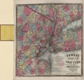
English: Regional map emphasizing railroads and areas/names of local municipalities. Relief shown by hachures. "Entered according to Act of Congress, in the year 1866, by H.H. Lloyd & Co., in the Clerk's Office of the District Court of the United States for the Southern District of New York." Includes text, notes, and publisher's map list. Map on verso: H.H. Lloyd's new map of the great metropolis : including the cities of New York, Brooklyn, Jersey City, Hoboken, &c. Map sheet signed in lead-pencil script on verso: Millard Fillmore, at N. York, Oct. 9, 1868; signed in ink script on inside of cover: Millard Fillmore, Oct. 9, 1868. Available also through the Library of Congress Web site as a raster image. |
||
| Title | 40 miles around New York | ||
| Shelf ID | G3804.N4A1 1867 .L4 | ||
| Date | |||
| Source | https://www.loc.gov/item/2015591057/ | ||
| Author | H.H. Lloyd & Co.; Fisk & Russell | ||
| Permission (Reusing this file) |
|
||
| Other versions |
|
||
| Location | New York Region. · Jersey City · New Jersey · Brooklyn. · New York City · Hoboken. · United States · Brooklyn · New York · New York. · Hoboken · New York Region · New York (State) · Jersey City. | ||
| Part of | American Memory · Cities And Towns · Catalog · Geography And Map Division · General Maps | ||
| Subject | New York (State) · Jersey City · New York Region · New Jersey · Railroads · New York (N.Y.) · United States · Maps · Brooklyn · New York · Brooklyn (New York, N.Y.) · Administrative And Political Divisions · Hoboken · Jersey City (N.J.) · Hoboken (N.J.) |

Licensing
[edit]
|
This is a faithful photographic reproduction of a two-dimensional, public domain work of art. The work of art itself is in the public domain for the following reason:
The official position taken by the Wikimedia Foundation is that "faithful reproductions of two-dimensional public domain works of art are public domain".
This photographic reproduction is therefore also considered to be in the public domain in the United States. In other jurisdictions, re-use of this content may be restricted; see Reuse of PD-Art photographs for details. | ||||
File history
Click on a date/time to view the file as it appeared at that time.
| Date/Time | Thumbnail | Dimensions | User | Comment | |
|---|---|---|---|---|---|
| current | 07:49, 15 June 2018 | | 10,173 × 9,701 (18.5 MB) | Fæ (talk | contribs) | LOC Maps https://www.loc.gov/item/2015591057/ #16108 |
You cannot overwrite this file.
File usage on Commons
The following page uses this file: