File:403 near Jerseyville.png
Jump to navigation
Jump to search

Size of this preview: 800 × 533 pixels. Other resolutions: 320 × 213 pixels | 640 × 427 pixels | 1,024 × 682 pixels | 1,280 × 853 pixels | 3,028 × 2,018 pixels.
Original file (3,028 × 2,018 pixels, file size: 10.03 MB, MIME type: image/png)
Captions
Captions
Add a one-line explanation of what this file represents
Summary
[edit]
| Description |
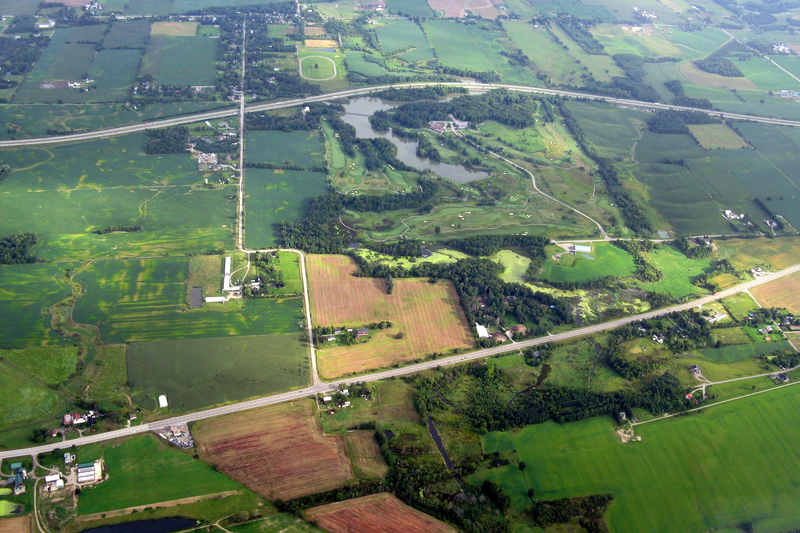
English: Aerial view of Highway 403 (further) and former Highway 2 / 53 (closer). The community in the background is Jerseyville, Ontario. The lake is Dunmark Lake. |
| Date | |
| Source |
Derivative of Southern Ontario from the Air
|
| Author | Uploaded by Floydian at en.wikipedia |
Licensing
[edit]
This file is licensed under the Creative Commons Attribution-Share Alike 2.0 Generic license.
- You are free:
- to share – to copy, distribute and transmit the work
- to remix – to adapt the work
- Under the following conditions:
- attribution – You must give appropriate credit, provide a link to the license, and indicate if changes were made. You may do so in any reasonable manner, but not in any way that suggests the licensor endorses you or your use.
- share alike – If you remix, transform, or build upon the material, you must distribute your contributions under the same or compatible license as the original.
| This image, originally posted to Flickr, was reviewed on 24 October 2011 by the administrator or reviewer Leoboudv, who confirmed that it was available on Flickr under the stated license on that date. |
Original upload log
[edit]
The original description page was here. All following user names refer to en.wikipedia.
Upload date | User | Bytes | Dimensions | Comment
- 2011-10-22 15:43 (UTC) | Floydian | 10515864 (bytes) | 3028×2018 | {{Information |Description=Aerial view of Highway 403 (further) and former Highway 2 / 53 (closer). The community in the background is [[Jerseyville, Ontario]]. The lake is Dunmark Lake. |Source=Derivative of [https://www.flickr.com/photos/paulhami/2813736269/in/photostream/ Southern Ontario from the Air] |Date=August 28, 2008 |Author=[https://www.flickr.com/photos/paulhami/ Paul Hamilton] |other_versions= }} {{Keep local}} [[Category:Aerial photographs of Ontario roads]]
| Annotations | This image is annotated: View the annotations at Commons |
File history
Click on a date/time to view the file as it appeared at that time.
| Date/Time | Thumbnail | Dimensions | User | Comment | |
|---|---|---|---|---|---|
| current | 05:36, 24 October 2011 | | 3,028 × 2,018 (10.03 MB) | SreeBot (talk | contribs) | (Original text) : {{Information |Description=Aerial view of Highway 403 (further) and former Highway 2 / 53 (closer). The community in the background is Jerseyville, Ontario. The lake is Dunmark Lake. |Source=Derivative of [http://www.flickr.com/photo |
You cannot overwrite this file.
File usage on Commons
The following page uses this file: