File:3rd Winchester Final Stand.png
Jump to navigation
Jump to search

Size of this preview: 792 × 600 pixels. Other resolutions: 317 × 240 pixels | 634 × 480 pixels | 808 × 612 pixels.
Original file (808 × 612 pixels, file size: 996 KB, MIME type: image/png)
Captions
Captions
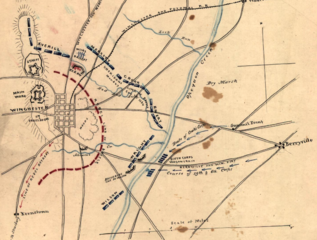
Sheridan's army nearly surrounded Early's Confederate (rebel) force at Winchester, Virginia.
Summary
[edit]
| Description |
English: On September 19, 1864, Philip Sheridan's Army of the Shenandoah defeated Jubal Early's Army of the Valley at Winchester, Virginia, in the American Civil War. Sheridan attacked from multiple sides and nearly surrounded Early's army. NOTE: the positions of Red Bud Run and Abrams Creek are doubtful. Emory was south of Red Bud Run. Abrams Creek is south of the Berryville Pike and separated Wright and Wilson—compare to other maps in this category. |
| Date | |
| Source | This is a portion of an 1873 map of the 3rd Battle of Winchester (near the end) that took place near Winchester, Virginia on September 19, 1864. It is part of the Hotchkiss map collection, no. 185, prepared by Major Jedediah Hotchkiss (1828-1899). The Library of Congress says the maps in the collection were published prior to 1922. The entire map can be found in the Library of Congress map. |
| Author | Major Jedediah Hotchkiss (1828-1899), a cartographer for the Confederate States of America. |
| Camera location | | View this and other nearby images on: OpenStreetMap |
|---|
Licensing
[edit]
|
This work is in the public domain in its country of origin and other countries and areas where the copyright term is the author's life plus 70 years or fewer. This work is in the public domain in the United States because it was published (or registered with the U.S. Copyright Office) before January 1, 1929. | |
| This file has been identified as being free of known restrictions under copyright law, including all related and neighboring rights. | |
File history
Click on a date/time to view the file as it appeared at that time.
| Date/Time | Thumbnail | Dimensions | User | Comment | |
|---|---|---|---|---|---|
| current | 19:05, 17 January 2021 | | 808 × 612 (996 KB) | TwoScarsUp (talk | contribs) | Uploaded a work by Major Jedediah Hotchkiss (1828-1899), a cartographer for the Confederate States of America. from This is a portion of an 1873 map of the 3rd Battle of Winchester (near the end) that took place near Winchester, Virginia on September 19, 1864. It is part of the Hotchkiss map collection, no. 185, prepared by Major Jedediah Hotchkiss (1828-1899). The Library of Congress says the maps in the collection were published prior to 1922. The entire map can be found in the Library of... |
You cannot overwrite this file.
File usage on Commons
There are no pages that use this file.