File:3 Latymer Schools map.svg
Jump to navigation
Jump to search

Size of this PNG preview of this SVG file: 800 × 450 pixels. Other resolutions: 320 × 180 pixels | 640 × 360 pixels | 1,024 × 576 pixels | 1,280 × 720 pixels | 2,560 × 1,440 pixels.
Original file (SVG file, nominally 1,280 × 720 pixels, file size: 7 KB)
Captions
Captions
3 Latymer Schools map
Summary
[edit]
| Description |
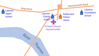
English: Map of the three places in Hammersmith where Latymer Foundation schools have been situated |
| Date | |
| Source | Own work |
| Author | Chiswick Chap |
Based on Davis, Sian; Gregg, Christine Letter, eds. (2024). Latymer 400: The Latymer Foundation at Hammersmith 1624–2024. Profile Editions. ISBN 978-1-7881-6811-3, page 228.
Licensing
[edit]
I, the copyright holder of this work, hereby publish it under the following license:
This file is licensed under the Creative Commons Attribution-Share Alike 4.0 International license.
- You are free:
- to share – to copy, distribute and transmit the work
- to remix – to adapt the work
- Under the following conditions:
- attribution – You must give appropriate credit, provide a link to the license, and indicate if changes were made. You may do so in any reasonable manner, but not in any way that suggests the licensor endorses you or your use.
- share alike – If you remix, transform, or build upon the material, you must distribute your contributions under the same or compatible license as the original.
File history
Click on a date/time to view the file as it appeared at that time.
| Date/Time | Thumbnail | Dimensions | User | Comment | |
|---|---|---|---|---|---|
| current | 16:17, 18 March 2024 | | 1,280 × 720 (7 KB) | Chiswick Chap (talk | contribs) | detail, label |
| 11:16, 18 March 2024 |  | 1,280 × 720 (7 KB) | Chiswick Chap (talk | contribs) | Uploaded own work with UploadWizard |
You cannot overwrite this file.
File usage on Commons
There are no pages that use this file.
File usage on other wikis
The following other wikis use this file:
- Usage on en.wikipedia.org