File:360 degrees around my back garden (geograph 6442872).jpg
Jump to navigation
Jump to search

Size of this preview: 800 × 249 pixels. Other resolutions: 320 × 100 pixels | 640 × 199 pixels | 1,024 × 319 pixels | 1,280 × 399 pixels | 2,560 × 797 pixels | 12,000 × 3,736 pixels.
Original file (12,000 × 3,736 pixels, file size: 7.43 MB, MIME type: image/jpeg)
Captions
Captions
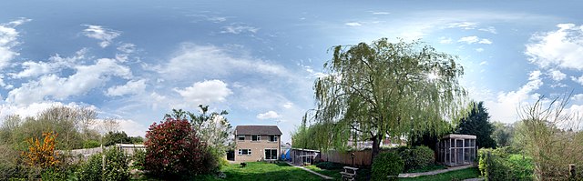
360 degrees around my back garden
Summary
[edit].jpg&action=edit§ion=1)
| Description |
English: 360 degrees around my back garden This is a Mercator-style projection of a hemi-spherical panorama. The top edge is a single point at the zenith, and the left hand side and the right hand side are the same point, a small fence used to keep the dogs near the house. Visible on the left are the two wooden pens used for the cat charity for which my wife houses animals. They both face North, but the projection has rotated the apparent direction of one relative to the other. The centre of this projection, due East, is the house. There are 78 individual images here, stitched by Microsoft's Image Composite Editor. See TF0820 : Garden Seat for one of the constituent images. The whole is an exercise in producing such panoramas, which may become a feature of the site one day. A few days later I made an audio recording of the Dawn Chorus from the same spot, which can be found at File:Home_Dawn_Chorus_2020-04-28_0600.mp3 |
| Date | |
| Source | From geograph.org.uk |
| Author | Bob Harvey |
| Permission (Reusing this file) |
Creative Commons Attribution Share-alike license 2.0 |
| Attribution (required by the license) | Bob Harvey / 360 degrees around my back garden / |
.jpg)
| Camera location | | View this and other nearby images on: OpenStreetMap |
|---|
.jpg¶ms=052.772509_N_-000.392035_E_globe:Earth_type:camera_source:geograph-osgb36(TF0857420647)_heading:90.00&language=en)
| Object location | | View this and other nearby images on: OpenStreetMap |
|---|
.jpg¶ms=052.772510_N_-000.392040_E_globe:Earth_class:object_type:object_source:geograph-osgb36(TF0857420647)_heading:90.00&language=en)
| 360° | View in 360° panoramic viewer
|
|---|
.jpg)
Licensing
[edit].jpg&action=edit§ion=2)

|
This image was taken from the Geograph project collection. See this photograph's page on the Geograph website for the photographer's contact details. The copyright on this image is owned by Bob Harvey and is licensed for reuse under the Creative Commons Attribution-ShareAlike 2.0 license.
|
This file is licensed under the Creative Commons Attribution-Share Alike 2.0 Generic license.
Attribution: Bob Harvey
- You are free:
- to share – to copy, distribute and transmit the work
- to remix – to adapt the work
- Under the following conditions:
- attribution – You must give appropriate credit, provide a link to the license, and indicate if changes were made. You may do so in any reasonable manner, but not in any way that suggests the licensor endorses you or your use.
- share alike – If you remix, transform, or build upon the material, you must distribute your contributions under the same or compatible license as the original.
File history
Click on a date/time to view the file as it appeared at that time.
| Date/Time | Thumbnail | Dimensions | User | Comment | |
|---|---|---|---|---|---|
| current | 11:54, 2 May 2020 | 12,000 × 3,736 (7.43 MB) | Robert EA Harvey (talk | contribs) | Transferred from geograph.co.uk using [https://tools.wmflabs.org/geograph2commons/ geograph2commons] |
You cannot overwrite this file.
File usage on Commons
There are no pages that use this file.
.jpg&oldid=945711841)