File:33 قلعة دوبيه - شقرا.jpg
Original file (5,472 × 3,648 pixels, file size: 9.44 MB, MIME type: image/jpeg)
Captions
Summary
[edit]Description33 قلعة دوبيه - شقرا.jpg |
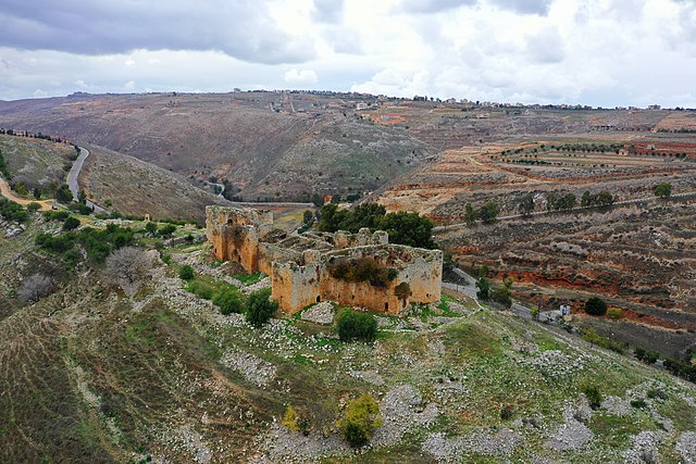
English: Doubay Castle ruins near Chaqra, Nabatieh Governorate, Lebanon
العربية: قلعة دوبيه - شقرا - جنوب لبنان
– أصل التسمية هناك رأي أن اسمها يعود إلى اسم (دي بويون) من (فرانسوا دي بويون) وهو أحد القادة الصليبيين. – وصف القلعة هي قلعة قديمة لها خندق كبير وفيها لوازم الحصار يحيط بها واد من جهاتها الثلاث ما عدا الجنوبية منها . لها ربض من غربها يعرف بالزنار. يبلغ طولها حوالي سبعون متراً وعرضها حوالي الأربعين فيها ثلاث طبقات والثالثة مهدمة بفعل الاعتداءات الإسرائيلية سنة 1972 وفيها حوالي الثلاثون غرفة وحجرة داخلها يوجد بئر يعرف بالمشنقة وخارجها خزان كبير حفر في الصخر الأصم. |
Date | |
Source | Own work |
Author | Ibrahimamirnaeem |
Camera location | 33° 11′ 41.79″ N, 35° 29′ 09.16″ E | View this and other nearby images on: OpenStreetMap | 33.194943; 35.485879 |
---|
Licensing
[edit]- You are free:
- to share – to copy, distribute and transmit the work
- to remix – to adapt the work
- Under the following conditions:
- attribution – You must give appropriate credit, provide a link to the license, and indicate if changes were made. You may do so in any reasonable manner, but not in any way that suggests the licensor endorses you or your use.
- share alike – If you remix, transform, or build upon the material, you must distribute your contributions under the same or compatible license as the original.
This image was uploaded as part of Wiki Loves Monuments 2020.
Afrikaans ∙ Alemannisch ∙ العربية ∙ جازايرية ∙ azərbaycanca ∙ Bikol Central ∙ беларуская ∙ беларуская (тарашкевіца) ∙ български ∙ বাংলা ∙ brezhoneg ∙ bosanski ∙ català ∙ čeština ∙ Cymraeg ∙ dansk ∙ Deutsch ∙ Zazaki ∙ Ελληνικά ∙ English ∙ Esperanto ∙ español ∙ eesti ∙ euskara ∙ فارسی ∙ suomi ∙ français ∙ Frysk ∙ Gaeilge ∙ galego ∙ עברית ∙ हिन्दी ∙ hrvatski ∙ magyar ∙ հայերեն ∙ Bahasa Indonesia ∙ Ido ∙ italiano ∙ 日本語 ∙ ქართული ∙ 한국어 ∙ кыргызча ∙ Lëtzebuergesch ∙ latviešu ∙ Malagasy ∙ македонски ∙ മലയാളം ∙ Bahasa Melayu ∙ Malti ∙ norsk bokmål ∙ नेपाली ∙ Nederlands ∙ norsk nynorsk ∙ norsk ∙ polski ∙ português ∙ português do Brasil ∙ română ∙ русский ∙ sicilianu ∙ davvisámegiella ∙ slovenčina ∙ slovenščina ∙ shqip ∙ српски / srpski ∙ svenska ∙ ไทย ∙ Tagalog ∙ Türkçe ∙ українська ∙ اردو ∙ oʻzbekcha / ўзбекча ∙ Yorùbá ∙ 中文 ∙ 中文(中国大陆) ∙ 中文(简体) ∙ 中文(繁體) ∙ 中文(香港) ∙ 中文(臺灣) ∙ +/− |
File history
Click on a date/time to view the file as it appeared at that time.
Date/Time | Thumbnail | Dimensions | User | Comment | |
---|---|---|---|---|---|
current | 01:24, 7 November 2020 | 5,472 × 3,648 (9.44 MB) | Ibrahimamirnaeem (talk | contribs) | Uploaded own work with UploadWizard |
You cannot overwrite this file.
File usage on Commons
There are no pages that use this file.
Metadata
This file contains additional information such as Exif metadata which may have been added by the digital camera, scanner, or software program used to create or digitize it. If the file has been modified from its original state, some details such as the timestamp may not fully reflect those of the original file. The timestamp is only as accurate as the clock in the camera, and it may be completely wrong.
Image title | default |
---|---|
Camera manufacturer | Hasselblad |
Camera model | L1D-20c |
Author | Picasa |
Exposure time | 1/200 sec (0.005) |
F-number | f/5.6 |
ISO speed rating | 100 |
Date and time of data generation | 12:12, 1 January 2020 |
Lens focal length | 10.26 mm |
Latitude | 33° 11′ 41.8″ N |
Longitude | 35° 29′ 9.16″ E |
Altitude | 489.4 meters above sea level |
Width | 5,472 px |
Height | 3,648 px |
Bits per component |
|
Number of components | 3 |
Horizontal resolution | 72 dpi |
Vertical resolution | 72 dpi |
Software used | 10.00.10.04 |
File change date and time | 03:17, 7 November 2020 |
Y and C positioning | Centered |
Exposure Program | Aperture priority |
Exif version | 2.3 |
Date and time of digitizing | 12:12, 1 January 2020 |
Meaning of each component |
|
APEX exposure bias | 0 |
Maximum land aperture | 2.971 APEX (f/2.8) |
Metering mode | Center weighted average |
Light source | Daylight |
Flash | Flash did not fire |
Supported Flashpix version | 1 |
Color space | sRGB |
File source | Digital still camera |
Scene type | A directly photographed image |
Exposure mode | Auto exposure |
White balance | Auto white balance |
Digital zoom ratio | 1 |
Focal length in 35 mm film | 28 mm |
Scene capture type | Standard |
Scene control | None |
Contrast | Hard |
Saturation | Normal |
Sharpness | Hard |
Unique image ID | 5370eb36d7dc1ad519a52cd83a9851a9 |
GPS tag version | 0.0.3.2 |
IIM version | 4 |
Structured data
Items portrayed in this file
depicts
some value
1 January 2020
33°11'41.795"N, 35°29'9.164"E
0.005 second
5.6
10.26 millimetre
100
image/jpeg
30f004bb8b6075602ce2e7581a1c86c6ee1d7ca7
9,901,579 byte
3,648 pixel
5,472 pixel
- Files with coordinates missing SDC location of creation
- CC-BY-SA-4.0
- Self-published work
- Images from Wiki Loves Monuments 2020
- Images from Wiki Loves Monuments 2020 in Lebanon
- Images from Wiki Loves Monuments missing SDC depicts
- Images from Wiki Loves Monuments missing SDC location of creation
- Uploaded via Campaign:wlm-lb