File:300 ma atm temp mean 2.png

Original file (816 × 544 pixels, file size: 302 KB, MIME type: image/png)
Captions
Captions
Summary
[edit]
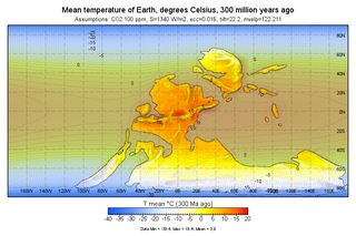
| Description |
English: Mean annual temperature degrees celcius, 300 million years ago |
| Date | |
| Source | Own work |
| Author | Merikanto |
This image is based simulation output from ccgenie muffins simulator, own experiment.
https://www.seao2.info/mymuffin.html https://github.com/derpycode/cgenie.muffin
Landsea information is from
PaleoDEM Resource – Scotese and Wright (2018)
11 August, 2018 by Sabin Zahirovic
https://www.earthbyte.org/paleodem-resource-scotese-and-wright-2018/
http://www.earthbyte.org/webdav/ftp/Data_Collections/Scotese_Wright_2018_PaleoDEM/Scotese_Wright_2018_Maps_1-88_1degX1deg_PaleoDEMS_nc.zip https://www.earthbyte.org/paleodem-resource-scotese-and-wright-2018/
Dem process to mask
Codes to capture info
File:300_ma_atmosphere_near_surface_temp_mean_1.png
R code to downscale temperature, assume global 6.5 c/100 m
- "R" temperature downscaler
library(raster)
library(ncdf4)
library(rgdal)
library(viridis)
downscale_temperature_65 <- function (coarse_rastera, fine_rastera)
	{
	## methods: 0 delta, 1 spatialeco, 2 dissever, 3 temperature lapse 6.5 C/1 km lm
print ("Downscaling temperature, 6.5 C/1 km")
	coarse_raster<-coarse_rastera
	fine_raster<-fine_rastera
	p1<-fine_raster
	p2<-fine_raster
	plot(fine_raster)
	plot(coarse_raster, col=viridis(200))
	coarseoro<- resample(p1, coarse_raster)
	coarseoro_big<-resample(coarseoro, p1)
	orodelta<-(p1-coarseoro_big)
	baset1 <- resample(coarse_raster, p1)
	raster_stack <- stack(p1,p2)
	orotemp<-orodelta*0.0065*-1
	coarseorotemp<- resample(orotemp, coarse_raster)
	coarseorotemp_big<-resample(coarseorotemp, p1)
	orotempdelta<-orotemp-coarseorotemp_big
	outtemp<-baset1+orotempdelta
	#outtempr<-rotate(outtemp)
	#plot(outtempr)
return(outtemp)
}
coarsename1<-"atm_temp.nc"
finename1<-"./indata1/Map57_PALEOMAP_6min_Late_Pennsylvanian_300Ma.nc"
coarser1<-raster(coarsename1)
finer1<-raster(finename1)
finer2<-finer1
finer2[finer2<0.0]<-0.0
rout1<-downscale_temperature_65(coarser1, finer2)
ext1<-extent(-180,180,-90,90)
crs1<-"+proj=longlat +datum=WGS84 +no_defs +ellps=WGS84 +towgs84=0,0,0"
crs(rout1)<-crs1
extent(rout1 )<-ext1
image(rout1)
writeRaster(rout1, "temp_dskaled1.nc", overwrite=TRUE, format="CDF", varname="atm_temp", varunit="degC",
longname="atm_temp", xname="lon", yname="lat")
Licensing
[edit]
- You are free:
- to share – to copy, distribute and transmit the work
- to remix – to adapt the work
- Under the following conditions:
- attribution – You must give appropriate credit, provide a link to the license, and indicate if changes were made. You may do so in any reasonable manner, but not in any way that suggests the licensor endorses you or your use.
- share alike – If you remix, transform, or build upon the material, you must distribute your contributions under the same or compatible license as the original.
File history
Click on a date/time to view the file as it appeared at that time.
| Date/Time | Thumbnail | Dimensions | User | Comment | |
|---|---|---|---|---|---|
| current | 18:33, 8 January 2022 | | 816 × 544 (302 KB) | Merikanto (talk | contribs) | Update |
| 11:40, 7 January 2022 |  | 2,192 × 1,472 (1.17 MB) | Merikanto (talk | contribs) | Uploaded own work with UploadWizard |
You cannot overwrite this file.
File usage on Commons
There are no pages that use this file.