File:26th MEU Hurricane Sandy Response (Image 60 of 60) (8164650485).jpg

Original file (1,280 × 720 pixels, file size: 614 KB, MIME type: image/jpeg)
Captions
Captions
Summary
[edit]_(8164650485).jpg&action=edit§ion=1)
| Description |
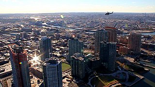
A UH-1N Huey assigned to Marine Light Attack Helicopter Squadron (HMLA) 467, transports Marines assigned to 26th Marine Expeditionary Unit command element, Nov. 3, 2012, to conduct a humanitarian assistance survey of New York City in support of Hurricane Sandy disaster relief efforts in New York and New Jersey. The 26th MEU is able to provide generators, fuel, clean water, and helicopter lift capabilities to aid in disaster relief efforts. The 26th MEU was currently conducting pre-deployment training, preparing for their departure in 2013. As an expeditionary force operating from the sea, the MEU is a Marine Air-Ground Task Force capable of conducting amphibious operations, crisis response, and limited contingency operations. (U.S. Marine Corps photo by Gunnery Sgt. Michael Kropiewnicki/Released) 26th Marine Expeditionary Unit Date Taken:11.03.2012 Location:NEW YORK, NY, US Read more: www.dvidshub.net/image/775198/26th-meu-hurricane-sandy-re... |
| Date | Taken on 3 November 2012 19:32 |
| Source | 26th MEU Hurricane Sandy Response [Image 60 of 60] |
| Author | DVIDSHUB |
| Camera location | | View this and other nearby images on: OpenStreetMap |
|---|
_(8164650485).jpg¶ms=040.714550_N_-074.007118_E_globe:Earth_type:camera_source:Flickr_&language=en)
Licensing
[edit]_(8164650485).jpg&action=edit§ion=2)
This image is a work of a U.S. military or Department of Defense employee, taken or made as part of that person's official duties. As a work of the U.S. federal government, the image is in the public domain in the United States.
|
 |
| This image was originally posted to Flickr by DVIDSHUB at https://flickr.com/photos/28650594@N03/8164650485. It was reviewed on 28 November 2016 by FlickreviewR and was confirmed to be licensed under the terms of the cc-by-2.0. |
This image is a work of a U.S. military or Department of Defense employee, taken or made as part of that person's official duties. As a work of the U.S. federal government, the image is in the public domain in the United States.
|
|
File history
Click on a date/time to view the file as it appeared at that time.
| Date/Time | Thumbnail | Dimensions | User | Comment | |
|---|---|---|---|---|---|
| current | 03:49, 28 November 2016 | | 1,280 × 720 (614 KB) | Reguyla (talk | contribs) | Transferred from Flickr via Flickr2Commons |
You cannot overwrite this file.
File usage on Commons
There are no pages that use this file.
Metadata
_(8164650485).jpg&oldid=855529386)
- 26th Marine Expeditionary Unit
- Relief efforts for Hurricane Sandy
- Effects of Hurricane Sandy in Queens
- Queens West
- Bell UH-1N (United States Marine Corps)
- Long Island City skylines
- Views of Long Island City, Queens from above
- Helicopters in flight over New York City
- Aerial photographs of Queens, New York City
- November 2012 in Queens, New York City
- 2012 in Long Island City, Queens
- New York City skyline in 2012