File:24216-La Jemaye-Ponteyraud-géologie.svg
Jump to navigation
Jump to search

Size of this PNG preview of this SVG file: 710 × 600 pixels. Other resolutions: 284 × 240 pixels | 568 × 480 pixels | 910 × 768 pixels | 1,213 × 1,024 pixels | 2,425 × 2,048 pixels | 881 × 744 pixels.
Original file (SVG file, nominally 881 × 744 pixels, file size: 3.81 MB)
Captions
Captions
Add a one-line explanation of what this file represents
Summary
[edit]
| Description |
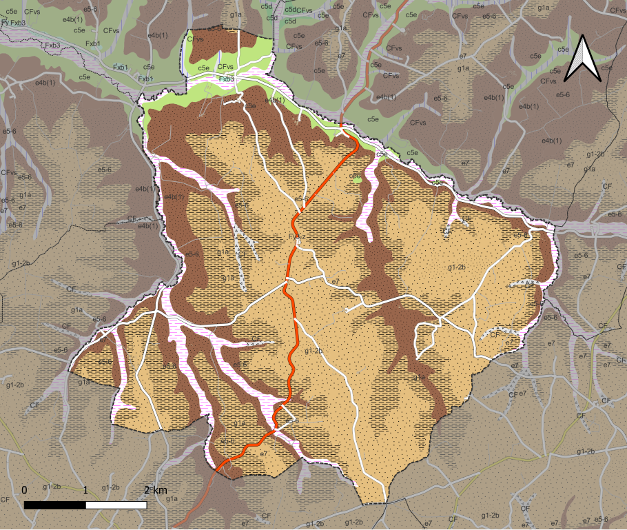
Français : Carte du zonage géologique de la commune de la commune de fr:La Jemaye-Ponteyraud (France). |
| Date | |
| Source |
Own work avec les données : * Découpage administratif communal et départemental : Export simple de janvier 2020 - vérifié et simplifié à 5 m sur le site du portail de données libres du gouvernement français, élaboré avec le concours des contributeurs à OpenStreetMap * Réseau routier : : Export openstreetmap de Geofabrik- version du 29 juin 2019 * zonage géologique : cartes géologiques départementales à 1/50 000 (Bd Charm-50) Assemblé et enrichi dans fr:QGis. |
| Author | Roland45 |
Licensing
[edit]
I, the copyright holder of this work, hereby publish it under the following license:
This file is licensed under the Creative Commons Attribution-Share Alike 4.0 International license.
- You are free:
- to share – to copy, distribute and transmit the work
- to remix – to adapt the work
- Under the following conditions:
- attribution – You must give appropriate credit, provide a link to the license, and indicate if changes were made. You may do so in any reasonable manner, but not in any way that suggests the licensor endorses you or your use.
- share alike – If you remix, transform, or build upon the material, you must distribute your contributions under the same or compatible license as the original.
File history
Click on a date/time to view the file as it appeared at that time.
| Date/Time | Thumbnail | Dimensions | User | Comment | |
|---|---|---|---|---|---|
| current | 08:46, 10 June 2022 | | 881 × 744 (3.81 MB) | Roland45 (talk | contribs) | pattypan 22.03 |
You cannot overwrite this file.
File usage on Commons
The following page uses this file:
File usage on other wikis
The following other wikis use this file:
- Usage on fr.wikipedia.org
Metadata
Categories:
- Geological maps of La Jemaye-Ponteyraud
- Formation Boisbreteau - maps
- Formation de Guizengeard (Dordogne) - maps
- Campanien 5: calcaires bioclastiques jaunâtres à rudistes, orbitoides media, Larrazetia, calcaires gréseux jaunes à grands silex versicolores, lumachelles à huîtres (formations d'Aubeterre, de Lalinde, de Couze) (Dordogne) - maps
- Formation de Guizengeard inf. : sables fins feldspathiques vert pâle à graviers et à matière organique, pyrite et argiles silteuses kaoliniques gris-verdâtres à blanchâtres à marmorisation / rubéfaction au sommet (Ypresian; Dordogne) - maps
- Formation de Guizengeard sup.: sables feldspathiques micacés, graviers, galets et argiles sableuses, ensemble ferrugineux (Lutetian-Bartonian. continental; Dordogne) - maps
- Formation Boisbreteau inf. : sable fin silto-argileux marron, à petits graviers et débris de cuirasses ferrugineuses, argile silteuse (Priabonian; Dordogne) - maps
- Formation de Boisbreteau moy. et formation de la Garde : sables feldspathiques à graviers et galets passant vers le sommet à des argiles sableuses (Rupelian; Dordogne) - maps
- Formation de Boisbreteau sup. : sables argileux feldspathiques à graviers et rares galets à la base, argiles silteuses verdâtres au sommet (Rupelian-Chattian; Dordogne) - maps
- Basses terrasses (RD Garonne) - Terrasse d'Izon (type 6) : séquence 3 (Saalian - Riss) - maps
- Alluvions subactuelles à actuelles indifférenciées (Quaternary; Dordogne) - maps
- Colluvions indifférenciées sablo-argileuses et argilo-sableuses de pentes et de vallons indifférenciés (Holocene; Dordogne) - maps
- Colluvions carbonatées de vallons secs : sable limoneux à débris calcaires et argile sableuse à débris (Holocene; Dordogne) - maps