File:23 & 23A Barker Gate, Nottingham (geograph 6112456).jpg
Jump to navigation
Jump to search

Size of this preview: 600 × 600 pixels. Other resolutions: 240 × 240 pixels | 480 × 480 pixels | 768 × 768 pixels | 1,024 × 1,024 pixels | 1,280 × 1,280 pixels.
Original file (1,280 × 1,280 pixels, file size: 466 KB, MIME type: image/jpeg)
Captions
Captions
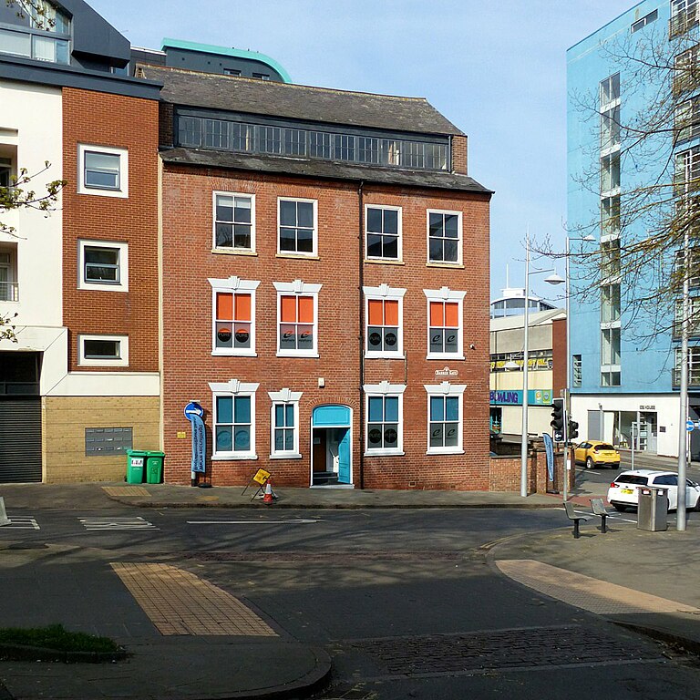
23 & 23A Barker Gate in the English city of Nottingham.
Summary
[edit].jpg&action=edit§ion=1)
| Description |
English: 23 & 23A Barker Gate in the English city of Nottingham. Originally a pair of houses, built c.1830, now refurbished as serviced offices following a fire in the late 20th century. The building illustrates a transitional stage in the lace industry between domestic and purpose-built industrial buildings. Listed Grade II. |
| Date | Taken on 1 April 2019 |
| Source | From geograph.org.uk |
| Author | Alan Murray-Rust |
| Permission (Reusing this file) |
Creative Commons Attribution Share-alike license 2.0 |
| Attribution (required by the license) | Alan Murray-Rust / 23 & 23A Barker Gate, Nottingham / |
This is a photo of listed building number 1246251. |
| Camera location | | View this and other nearby images on: OpenStreetMap |
|---|
.jpg¶ms=052.952296_N_-001.141442_E_globe:Earth_type:camera_source:geograph-osgb36(SK57783978)_heading:22.00&language=en)
| Object location | | View this and other nearby images on: OpenStreetMap |
|---|
.jpg¶ms=052.952470_N_-001.141290_E_globe:Earth_class:object_type:object_source:geograph-osgb36(SK57793980)_heading:22.00&language=en)
Licensing
[edit].jpg&action=edit§ion=2)

|
This image was taken from the Geograph project collection. See this photograph's page on the Geograph website for the photographer's contact details. The copyright on this image is owned by Alan Murray-Rust and is licensed for reuse under the Creative Commons Attribution-ShareAlike 2.0 license.
|
This file is licensed under the Creative Commons Attribution-Share Alike 2.0 Generic license.
Attribution: Alan Murray-Rust
- You are free:
- to share – to copy, distribute and transmit the work
- to remix – to adapt the work
- Under the following conditions:
- attribution – You must give appropriate credit, provide a link to the license, and indicate if changes were made. You may do so in any reasonable manner, but not in any way that suggests the licensor endorses you or your use.
- share alike – If you remix, transform, or build upon the material, you must distribute your contributions under the same or compatible license as the original.
File history
Click on a date/time to view the file as it appeared at that time.
| Date/Time | Thumbnail | Dimensions | User | Comment | |
|---|---|---|---|---|---|
| current | 17:47, 11 October 2023 | | 1,280 × 1,280 (466 KB) | Chris j wood (talk | contribs) | == {{int:filedesc}} == {{Information |Description={{en|1=23 & 23A Barker Gate, Nottingham}} |Source=From [https://www.geograph.org.uk/photo/6112456 geograph.org.uk] |Date=2019-04-01 |Author=[https://www.geograph.org.uk/profile/9181 Alan Murray-Rust] |Permission=Creative Commons Attribution Share-alike license 2.0 |Other fields={{Credit line |Author=Alan Murray-Rust |License=[https://creativecommons.org/licenses/by-sa/2.0/ CC BY-SA 2.0] |Other=''23 & 23A Barker Gate, Nottingham'' }} }} {{L... |
You cannot overwrite this file.
File usage on Commons
The following page uses this file:
File usage on other wikis
The following other wikis use this file:
- Usage on en.wikipedia.org
- Usage on www.wikidata.org
.jpg&oldid=916332467)