File:20th century atlas of Clinton County, Indiana - containing maps of villages, cities and townships of the county, of the state, United States and world, farmers directory, business directory and LOC 2007626767-11.jpg
Jump to navigation
Jump to search

Size of this preview: 358 × 599 pixels. Other resolutions: 143 × 240 pixels | 287 × 480 pixels | 459 × 768 pixels | 612 × 1,024 pixels | 1,224 × 2,048 pixels | 2,746 × 4,595 pixels.
Original file (2,746 × 4,595 pixels, file size: 1.93 MB, MIME type: image/jpeg)
Captions
Captions
Add a one-line explanation of what this file represents
Summary
[edit]| Description |
English: LeGear. Atlases of the United States, 4509 Available also through the Library of Congress Web site as a raster image. Includes indexes and brief biographies and portraits of early Clinton County residents. LC copy imperfect: Front board separated from binding. Vendor: John Carbonell (eBay auction) Acquisitions control no. 2006-108 |
||
| Title | 20th century atlas of Clinton County, Indiana : containing maps of villages, cities and townships of the county, of the state, United States and world, farmers directory, business directory and general information, analysis of the system of U.S. land surveys, digest of the system of civil government. | ||
| Shelf ID | G1403.C6 M5 1903 | ||
| Parent | https://www.loc.gov/resource/g4093cm.gla00052/ | ||
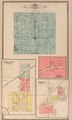
| Sheet title | Owen Twp.; Michigantown, Michigan Twp.; Pickard, Sugar Creek Twp.; Forest | ||
| Date | |||
| Source | https://www.loc.gov/item/2007626767/ | ||
| Author | Middle-West Publishing Co. | ||
| Permission (Reusing this file) |
|
||
| Other versions |
|
||
| Location | United States · Indiana · Clinton County | ||
| Part of | American Memory · Catalog · County Landownership Maps · Geography And Map Division · Cultural Landscapes | ||
| Subject | Clinton County (Ind.) · Portraits · Directories · Clinton County · United States · Maps · Indiana · Real Property · Landowners · Biography |

Licensing
[edit]
|
This is a faithful photographic reproduction of a two-dimensional, public domain work of art. The work of art itself is in the public domain for the following reason:
The official position taken by the Wikimedia Foundation is that "faithful reproductions of two-dimensional public domain works of art are public domain".
This photographic reproduction is therefore also considered to be in the public domain in the United States. In other jurisdictions, re-use of this content may be restricted; see Reuse of PD-Art photographs for details. | ||||
File history
Click on a date/time to view the file as it appeared at that time.
| Date/Time | Thumbnail | Dimensions | User | Comment | |
|---|---|---|---|---|---|
| current | 16:05, 9 June 2018 | | 2,746 × 4,595 (1.93 MB) | Fæ (talk | contribs) | LOC Maps multisheet https://www.loc.gov/item/2007626767/ sheet 11 of 56 #14819 |
You cannot overwrite this file.
File usage on Commons
The following page uses this file:
Categories:
- Maps in the Library of Congress
- 20th century atlas of Clinton County, Indiana - containing maps of villages, cities and townships of the county, of the state, United States and world, farmers directory, business directory and
- Owen Township, Clinton County, Indiana
- Pickard, Indiana
- Forest, Indiana
- Michigantown, Indiana