File:2024-08-08 Japan M7.1 earthquake shakemap (USGS).jpg
Jump to navigation
Jump to search

Size of this preview: 478 × 599 pixels. Other resolutions: 191 × 240 pixels | 383 × 480 pixels | 798 × 1,000 pixels.
Original file (798 × 1,000 pixels, file size: 131 KB, MIME type: image/jpeg)
Captions
Captions
Add a one-line explanation of what this file represents
Summary
[edit].jpg&action=edit§ion=1)
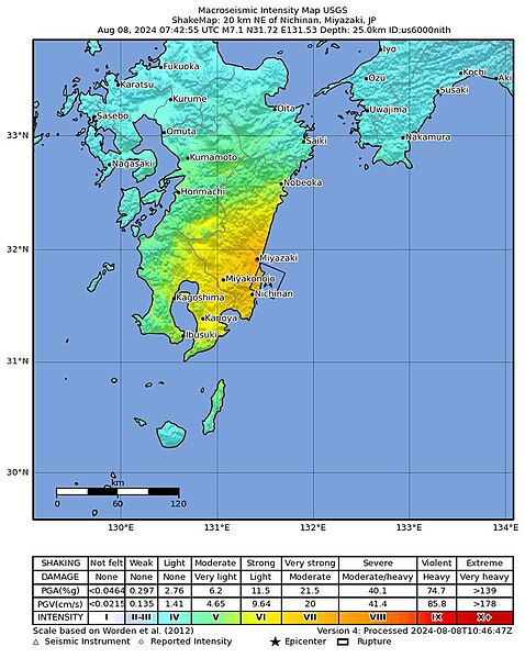
| Description |
Svenska: United States Geological Surveys ShakeMap från jordbävningen utanför Kyushu 2024.
English: United States Geological Survey's ShakeMap from the 2024 earthquake outside Kyushu. |
| Date | |
| Source | https://earthquake.usgs.gov/earthquakes/eventpage/us6000nith/shakemap/intensity |
| Author | United States Geological Survey |
Licensing
[edit].jpg&action=edit§ion=2)
This image is in the public domain in the United States because it only contains materials that originally came from the United States Geological Survey, an agency of the United States Department of the Interior. For more information, see the official USGS copyright policy.
|
File history
Click on a date/time to view the file as it appeared at that time.
| Date/Time | Thumbnail | Dimensions | User | Comment | |
|---|---|---|---|---|---|
| current | 14:36, 8 August 2024 | | 798 × 1,000 (131 KB) | Kakan spelar (talk | contribs) | Uploaded a work by United States Geological Survey from https://earthquake.usgs.gov/earthquakes/eventpage/us6000nith/shakemap/intensity with UploadWizard |
You cannot overwrite this file.
File usage on Commons
There are no pages that use this file.
File usage on other wikis
The following other wikis use this file:
- Usage on zh.wikipedia.org
.jpg&oldid=910388016)