File:2023 CWB Doksuri forecast map (en-US).png
Jump to navigation
Jump to search
Size of this preview: 800 × 586 pixels. Other resolutions: 320 × 234 pixels | 640 × 469 pixels | 956 × 700 pixels.
Original file (956 × 700 pixels, file size: 86 KB, MIME type: image/png)
Captions
Captions
Add a one-line explanation of what this file represents
Summary
[edit]| Description |
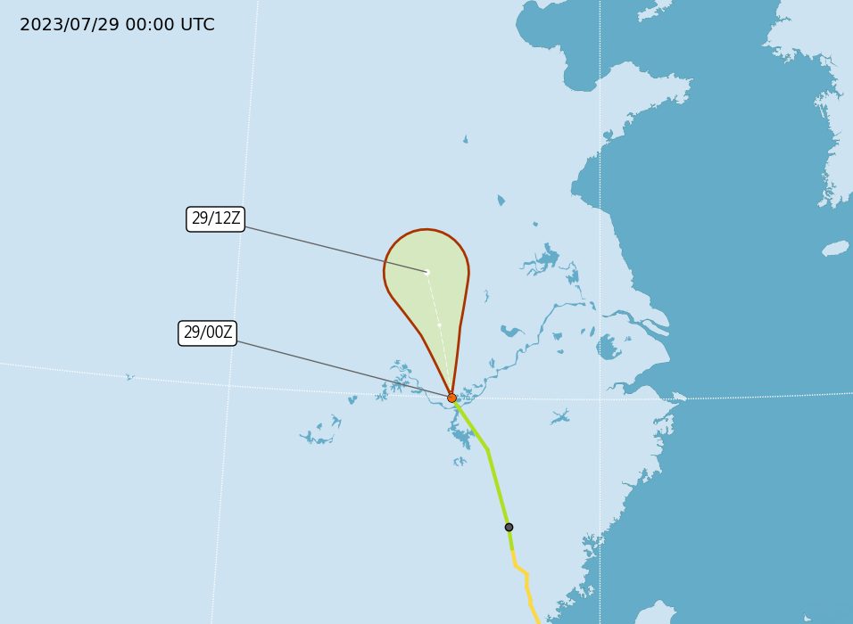
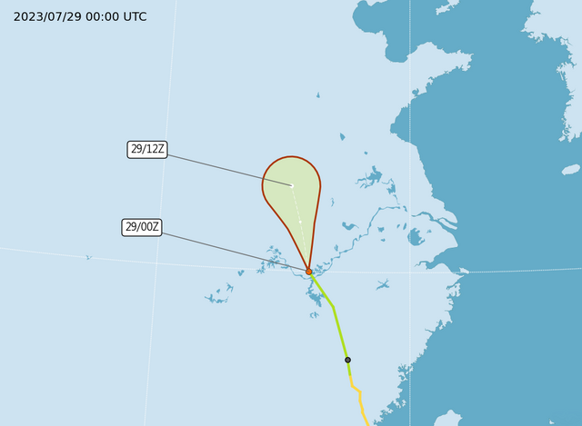
English: Central Weather Administration's forecast map of Northwest Pacific tropical depression Doksuri. |
| Date | |
| Source | https://www.cwb.gov.tw/Data/typhoon/TY_NEWS/Download_PTA_202307290000_TD06_enus.png |
| Author | Central Weather Administration |
| Other versions |
Traditional Chinese: .png) |

.png&action=edit§ion=1)
Licensing
[edit].png&action=edit§ion=2)

|
The copyright holder of this file, Central Weather Administration, allows anyone to use it for any purpose, provided that the copyright holder is properly attributed. Redistribution, derivative work, commercial use, and all other use is permitted. |
Attribution:
|
|
|
This file is licensed under the Government Website Open Information Announcement.
Information on Related Items:
|
 |
|
|
File history
Click on a date/time to view the file as it appeared at that time.
.png&dir=prev)
.png&offset=20230726200545)
.png&offset=&limit=20)
.png&offset=&limit=50)
.png&offset=&limit=100)
.png&offset=&limit=250)
.png&offset=&limit=500)
| Date/Time | Thumbnail | Dimensions | User | Comment | |
|---|---|---|---|---|---|
| current | 02:06, 29 July 2023 | | 956 × 700 (86 KB) | Cewbot (talk | contribs) | Import CWB tropical cyclone forecast map of Northwest Pacific tropical depression Doksuri: Position 290000Z at 30.0N 116.0E, Movement: NNW 32km/hr. Minimum pressure 998 hpa, Max sustained winds near center 15 meter per second, Gusts 23 meter per second. https://www.cwb.gov.tw/Data/typhoon/TY_NEWS/Download_PTA_202307290000_TD06_enus.png (2023-07-29 00:00 UTC) |
| 20:07, 28 July 2023 |  | 956 × 700 (94 KB) | Cewbot (talk | contribs) | Import CWB tropical cyclone forecast map of Northwest Pacific tropical storm Doksuri: Position 281800Z at 28.8N 117.0E, Movement: N 30km/hr. Minimum pressure 995 hpa, Max sustained winds near center 20 meter per second, Gusts 28 meter per second, Average radius of over 15m/s winds 120km(50km NW quad. , 110km NE quad. , 220km SW quad. , 110km SE quad. ), Average radius of over 25m/s winds -km. https://www.cwb.gov.tw/Data/typhoon/TY_NEWS/Download_PTA_202307281800_... | |
| 13:31, 28 July 2023 |  | 956 × 700 (98 KB) | Cewbot (talk | contribs) | Import CWB tropical cyclone forecast map of Northwest Pacific tropical storm Doksuri: Position 281200Z at 27.0N 117.6E, Movement: N 36km/hr. Minimum pressure 995 hpa, Max sustained winds near center 20 meter per second, Gusts 28 meter per second, Average radius of over 15m/s winds 120km(90km NW quad. , 170km NE quad. , 50km SW quad. , 170km SE quad. ), Average radius of over 25m/s winds -km. https://www.cwb.gov.tw/Data/typhoon/TY_NEWS/Download_PTA_202307281200_D... | |
| 08:05, 28 July 2023 |  | 956 × 700 (102 KB) | Cewbot (talk | contribs) | Import CWB tropical cyclone forecast map of Northwest Pacific typhoon Doksuri: Position 280600Z at 25.6N 118.1E, Movement: N 30km/hr. Minimum pressure 970 hpa, Max sustained winds near center 33 meter per second, Gusts 43 meter per second, Average radius of over 15m/s winds 180km(180km NW quad. , 190km NE quad. , 150km SW quad. , 190km SE quad. ), Average radius of over 25m/s winds 60km(60km NW quad. , 60km NE quad. , 50km SW quad. , 60km SE quad. ). https://www... | |
| 01:05, 28 July 2023 |  | 956 × 700 (107 KB) | Cewbot (talk | contribs) | Import CWB tropical cyclone forecast map of Northwest Pacific typhoon Doksuri: Position 280000Z at 24.0N 118.5E, Movement: NNW 32km/hr. Minimum pressure 945 hpa, Max sustained winds near center 43 meter per second, Gusts 53 meter per second, Average radius of over 15m/s winds 250km(230km NW quad. , 250km NE quad. , 250km SW quad. , 250km SE quad. ), Average radius of over 25m/s winds 80km(80km NW quad. , 90km NE quad. , 80km SW quad. , 80km SE quad. ). https://w... | |
| 20:06, 27 July 2023 |  | 956 × 700 (114 KB) | Cewbot (talk | contribs) | Import CWB tropical cyclone forecast map of Northwest Pacific typhoon Doksuri: Position 271800Z at 22.8N 119.0E, Movement: NNW 25km/hr. Minimum pressure 945 hpa, Max sustained winds near center 43 meter per second, Gusts 53 meter per second, Average radius of over 15m/s winds 250km(250km NW quad. , 250km NE quad. , 230km SW quad. , 250km SE quad. ), Average radius of over 25m/s winds 80km(80km NW quad. , 90km NE quad. , 60km SW quad. , 80km SE quad. ). https://w... | |
| 13:31, 27 July 2023 |  | 956 × 700 (129 KB) | Cewbot (talk | contribs) | Import CWB tropical cyclone forecast map of Northwest Pacific typhoon Doksuri: Position 271200Z at 21.8N 119.2E, Movement: NNW 18km/hr. Minimum pressure 945 hpa, Max sustained winds near center 43 meter per second, Gusts 53 meter per second, Average radius of over 15m/s winds 280km(280km NW quad. , 280km NE quad. , 260km SW quad. , 280km SE quad. ), Average radius of over 25m/s winds 90km(90km NW quad. , 90km NE quad. , 70km SW quad. , 90km SE quad. ). https://w... | |
| 07:31, 27 July 2023 |  | 956 × 700 (136 KB) | Cewbot (talk | contribs) | Import CWB tropical cyclone forecast map of Northwest Pacific typhoon Doksuri: Position 270600Z at 21.1N 119.3E, Movement: NNW 16km/hr. Minimum pressure 945 hpa, Max sustained winds near center 43 meter per second, Gusts 53 meter per second, Average radius of over 15m/s winds 280km(280km NW quad. , 280km NE quad. , 260km SW quad. , 280km SE quad. ), Average radius of over 25m/s winds 90km(90km NW quad. , 90km NE quad. , 70km SW quad. , 90km SE quad. ). https://w... | |
| 01:31, 27 July 2023 |  | 956 × 700 (133 KB) | Cewbot (talk | contribs) | Import CWB tropical cyclone forecast map of Northwest Pacific typhoon Doksuri: Position 270000Z at 20.8N 119.8E, Movement: NNW 13km/hr. Minimum pressure 945 hpa, Max sustaiNEd winds NEar center 43 meter per SEcond, Gusts 53 meter per SEcond, Average radius of over 15m/s winds 280km(280km NW quad. , 280km NE quad. , 280km SW quad. , 280km SE quad. ), Average radius of over 25m/s winds 90km(90km NW quad. , 90km NE quad. , 90km SW quad. , 90km SE quad. ). https://w... | |
| 20:05, 26 July 2023 |  | 956 × 700 (136 KB) | Cewbot (talk | contribs) | Import CWB tropical cyclone forecast map of Northwest Pacific typhoon Doksuri: Position 261800Z at 20.0N 120.1E, Movement: NNW 13km/hr. Minimum pressure 940 hpa, Max sustaiNEd winds NEar center 45 meter per SEcond, Gusts 55 meter per SEcond, Average radius of over 15m/s winds 280km(280km NW quad. , 280km NE quad. , 280km SW quad. , 280km SE quad. ), Average radius of over 25m/s winds 90km(100km NW quad. , 100km NE quad. , 60km SW quad. , 100km SE quad. ). https:... |
You cannot overwrite this file.
File usage on Commons
The following page uses this file:
.png&oldid=787799057)