File:2022 East Timor municipalities numbers.png
Jump to navigation
Jump to search

Size of this preview: 800 × 461 pixels. Other resolutions: 320 × 185 pixels | 640 × 369 pixels | 1,024 × 591 pixels | 1,280 × 738 pixels | 3,344 × 1,929 pixels.
Original file (3,344 × 1,929 pixels, file size: 222 KB, MIME type: image/png)
Captions
Captions
Add a one-line explanation of what this file represents
Summary
[edit]
| Description |
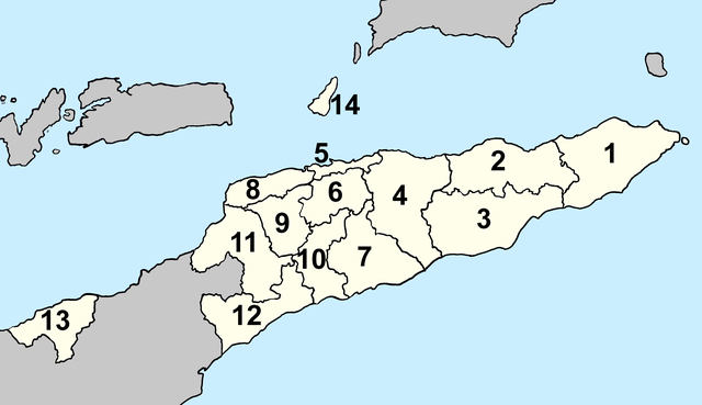
Deutsch: Lagekarte der Gemeinden Osttimors (nummeriert) seit 2022 English: Locator map of municipalities of East Timor (numbered) since 2022 |
| Date | |
| Source | Own work |
| Author | Patrick |
Licensing
[edit]
I, the copyright holder of this work, hereby publish it under the following licenses:

|
Permission is granted to copy, distribute and/or modify this document under the terms of the GNU Free Documentation License, Version 1.2 or any later version published by the Free Software Foundation; with no Invariant Sections, no Front-Cover Texts, and no Back-Cover Texts. A copy of the license is included in the section entitled GNU Free Documentation License. |
This file is licensed under the Creative Commons Attribution 4.0 International license.
- You are free:
- to share – to copy, distribute and transmit the work
- to remix – to adapt the work
- Under the following conditions:
- attribution – You must give appropriate credit, provide a link to the license, and indicate if changes were made. You may do so in any reasonable manner, but not in any way that suggests the licensor endorses you or your use.
You may select the license of your choice.
File history
Click on a date/time to view the file as it appeared at that time.
| Date/Time | Thumbnail | Dimensions | User | Comment | |
|---|---|---|---|---|---|
| current | 18:48, 4 April 2022 | | 3,344 × 1,929 (222 KB) | J. Patrick Fischer (talk | contribs) | {{Information |Description={{de|Lagekarte der Gemeinden Osttimors (nummeriert) seit 2022}} {{en|Locator map of municipalities of East Timor (numbered) since 2022}} |Source={{own}} |Date=2022-04-04 |Author=Patrick |Permission= |other_versions= }} == {{int:license-header}} == {{self|GFDL|cc-by-4.0}} Category:Maps of municipalities of East Timor Category:Maps of Subdivisions of East Timor Category:Images by J. Patrick Fischer |
You cannot overwrite this file.
File usage on Commons
There are no pages that use this file.
File usage on other wikis
The following other wikis use this file:
- Usage on de.wikipedia.org
- Usage on eo.wikipedia.org
- Usage on fa.wikipedia.org
- Usage on gl.wikipedia.org
- Usage on he.wikipedia.org
- Usage on id.wikipedia.org
- Usage on ja.wikipedia.org
- Usage on li.wikipedia.org
- Usage on lt.wikipedia.org
- Usage on ms.wikipedia.org
- Usage on nl.wikipedia.org
- Usage on pl.wikipedia.org
- Usage on pt.wikipedia.org
- Usage on tet.wikipedia.org
- Usage on tr.wikipedia.org
- Usage on uk.wikipedia.org
- Usage on vi.wikipedia.org
- Usage on zh-classical.wikipedia.org
- Usage on zh.wikipedia.org