File:2022 CWB Chaba forecast map (en-US).png
Jump to navigation
Jump to search
Size of this preview: 800 × 586 pixels. Other resolutions: 320 × 234 pixels | 640 × 469 pixels | 956 × 700 pixels.
Original file (956 × 700 pixels, file size: 105 KB, MIME type: image/png)
Captions
Captions
Add a one-line explanation of what this file represents
Summary
[edit]| Description |
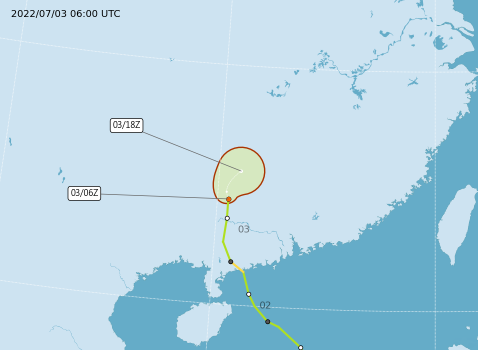
English: Central Weather Administration's forecast map of Northwest Pacific tropical depression Chaba. |
| Date | |
| Source | https://www.cwb.gov.tw/Data/typhoon/TY_NEWS/Download_PTA_202207030600_TD04_enus.png |
| Author | Central Weather Administration |
| Other versions |
Traditional Chinese: .png) |

.png&action=edit§ion=1)
Licensing
[edit].png&action=edit§ion=2)

|
The copyright holder of this file, Central Weather Administration, allows anyone to use it for any purpose, provided that the copyright holder is properly attributed. Redistribution, derivative work, commercial use, and all other use is permitted. |
Attribution:
|
|
|
This file is licensed under the Government Website Open Information Announcement.
Information on Related Items:
|
 |
|
|
File history
Click on a date/time to view the file as it appeared at that time.
.png&dir=prev)
.png&offset=20220701023203)
.png&offset=&limit=20)
.png&offset=&limit=50)
.png&offset=&limit=100)
.png&offset=&limit=250)
.png&offset=&limit=500)
| Date/Time | Thumbnail | Dimensions | User | Comment | |
|---|---|---|---|---|---|
| current | 07:26, 3 July 2022 | | 956 × 700 (105 KB) | Cewbot (talk | contribs) | Import CWB tropical cyclone forecast map of Northwest Pacific tropical depression Chaba: Position 030600Z at 24.4N 110.5E, Movement: NNW 6km/hr. Minimum pressure 995 hpa, Max sustained winds near center 15 meter per second, Gusts 23 meter per second. https://www.cwb.gov.tw/Data/typhoon/TY_NEWS/Download_PTA_202207030600_TD04_enus.png (2022-07-03 06:00 UTC) |
| 01:30, 3 July 2022 |  | 956 × 700 (99 KB) | Cewbot (talk | contribs) | Import CWB tropical cyclone forecast map of Northwest Pacific tropical storm Chaba: Position 030000Z at 23.6N 110.5E, Movement: N 9km/hr. Minimum pressure 990 hpa, Max sustained winds near center 20 meter per second, Gusts 28 meter per second, Radius of over 15m/s winds 100km. https://www.cwb.gov.tw/Data/typhoon/TY_NEWS/Download_PTA_202207030000_CHABA_enus.png (2022-07-03 00:00 UTC) | |
| 21:08, 2 July 2022 |  | 956 × 700 (110 KB) | Cewbot (talk | contribs) | Import CWB tropical cyclone forecast map of Northwest Pacific tropical storm Chaba: Position 021800Z at 22.6N 110.4E, Movement: NNW 13km/hr. Minimum pressure 988 hpa, Max sustained winds near center 23 meter per second, Gusts 30 meter per second, Radius of over 15m/s winds 120km. https://www.cwb.gov.tw/Data/typhoon/TY_NEWS/Download_PTA_202207021800_CHABA_enus.png (2022-07-02 18:00 UTC) | |
| 14:38, 2 July 2022 |  | 956 × 700 (115 KB) | Cewbot (talk | contribs) | Import CWB tropical cyclone forecast map of Northwest Pacific severe tropical storm Chaba: Position 021200Z at 21.8N 110.8E, Movement: NNW 17km/hr. Minimum pressure 978 hpa, Max sustained winds near center 30 meter per second, Gusts 38 meter per second, Radius of over 15m/s winds 180km, Radius of over 25m/s winds 60km. https://www.cwb.gov.tw/Data/typhoon/TY_NEWS/Download_PTA_202207021200_CHABA_enus.png (2022-07-02 12:00 UTC) | |
| 07:35, 2 July 2022 |  | 956 × 700 (116 KB) | Cewbot (talk | contribs) | Import CWB tropical cyclone forecast map of Northwest Pacific typhoon Chaba: Position 020600Z at 21.4N 111.4E, Movement: NNW 11km/hr. Minimum pressure 970 hpa, Max sustained winds near center 33 meter per second, Gusts 43 meter per second, Radius of over 15m/s winds 180km, Radius of over 25m/s winds 60km. https://www.cwb.gov.tw/Data/typhoon/TY_NEWS/Download_PTA_202207020600_CHABA_enus.png (2022-07-02 06:00 UTC) | |
| 01:08, 2 July 2022 |  | 956 × 700 (108 KB) | Cewbot (talk | contribs) | Import CWB tropical cyclone forecast map of Northwest Pacific severe tropical storm Chaba: Position 020000Z at 20.5N 111.7E, Movement: NW 16km/hr. Minimum pressure 975 hpa, Max sustained winds near center 30 meter per second, Gusts 38 meter per second, Radius of over 15m/s winds 180km, Radius of over 25m/s winds 60km. https://www.cwb.gov.tw/Data/typhoon/TY_NEWS/Download_PTA_202207020000_CHABA_enus.png (2022-07-02 00:00 UTC) | |
| 21:06, 1 July 2022 |  | 956 × 700 (112 KB) | Cewbot (talk | contribs) | Import CWB tropical cyclone forecast map of Northwest Pacific severe tropical storm Chaba: Position 011800Z at 20.0N 112.0E, Movement: NW 19km/hr. Minimum pressure 975 hpa, Max sustained winds near center 30 meter per second, Gusts 38 meter per second, Radius of over 15m/s winds 180km, Radius of over 25m/s winds 60km. https://www.cwb.gov.tw/Data/typhoon/TY_NEWS/Download_PTA_202207011800_CHABA_enus.png (2022-07-01 18:00 UTC) | |
| 13:32, 1 July 2022 |  | 956 × 700 (123 KB) | Cewbot (talk | contribs) | Import CWB tropical cyclone forecast map of Northwest Pacific severe tropical storm Chaba: Position 011200Z at 19.4N 112.6E, Movement: NW 18km/hr. Minimum pressure 978 hpa, Max sustained winds near center 30 meter per second, Gusts 38 meter per second, Radius of over 15m/s winds 180km, Radius of over 25m/s winds 60km. https://www.cwb.gov.tw/Data/typhoon/TY_NEWS/Download_PTA_202207011200_CHABA_enus.png (2022-07-01 12:00 UTC) | |
| 08:07, 1 July 2022 |  | 956 × 700 (119 KB) | Cewbot (talk | contribs) | Import CWB tropical cyclone forecast map of Northwest Pacific severe tropical storm Chaba: Position 010600Z at 19.2N 113.1E, Movement: WNW 14km/hr. Minimum pressure 978 hpa, Max sustained winds near center 28 meter per second, Gusts 35 meter per second, Radius of over 15m/s winds 150km. https://www.cwb.gov.tw/Data/typhoon/TY_NEWS/Download_PTA_202207010600_CHABA_enus.png (2022-07-01 06:00 UTC) | |
| 02:32, 1 July 2022 |  | 956 × 700 (144 KB) | Cewbot (talk | contribs) | Import CWB tropical cyclone forecast map of Northwest Pacific severe tropical storm Chaba: Position 010000Z at 18.4N 114.1E, Movement: NW 23km/hr. Minimum pressure 978 hpa, Max sustained winds near center 28 meter per second, Gusts 38 meter per second, Radius of over 15m/s winds 150km. https://www.cwb.gov.tw/Data/typhoon/TY_NEWS/Download_PTA_202207010000_CHABA_enus.png (2022-07-01 00:00 UTC) |
You cannot overwrite this file.
File usage on Commons
The following page uses this file:
.png&oldid=899044703)