File:20220416200DR Dresden Weißeritztalbrücke und Begerburg.jpg
Jump to navigation
Jump to search

Size of this preview: 800 × 595 pixels. Other resolutions: 320 × 238 pixels | 640 × 476 pixels | 1,024 × 761 pixels | 1,280 × 952 pixels | 2,560 × 1,903 pixels | 3,583 × 2,664 pixels.
Original file (3,583 × 2,664 pixels, file size: 7.21 MB, MIME type: image/jpeg)
Captions
Captions
Add a one-line explanation of what this file represents
Summary
[edit]| Description |
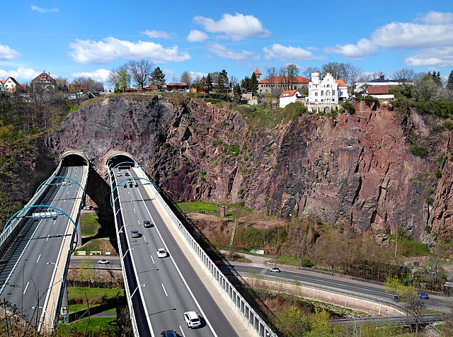
Deutsch: 16.04.2022 Dresden: Blick von Coschütz über den Plauenschen Grund nach Dölzschen mit der Begerburg (GMP: 51.023279,13.688878). 1852-1854 ließ der Dölzschener Gutsbesitzer Beger nach Plänen des Architekten Theodor Lehnert ein Restaurant im burgähnlichen Stil der Neogotik errichten. Die Schankkonzession wurde wegen der Absturzgefahr niemals erteilt. Im Vordergrund die Weißeritztalbrücke der Autobahn und der Dölzschener Tunnel. Bauzeit für die in Stahlverbundbauweise errichtete Brücke 1999 bis 2003. Sie ist 220 m lang und 35 m hoch und überbrückt die Vereinigte Weißeritz. Danach führt die A17 unmittelbar durch den Dölzschener Teil des 1070 m langen A17 Autobahntunnels bis Roßthal. Eröffnung der Teilstrecke von Dresden bis zur tschechischen Grenze war im Dezember 2006. [SAM5574.JPG]20220416200DR.JPG(c)Blobelt |
||||||||||||||
| Date | |||||||||||||||
| Source | Own work | ||||||||||||||
| Author |
|
||||||||||||||

| Object location | | View this and other nearby images on: OpenStreetMap |
|---|
Licensing
[edit]
This file is licensed under the Creative Commons Attribution-Share Alike 4.0 International license.
- You are free:
- to share – to copy, distribute and transmit the work
- to remix – to adapt the work
- Under the following conditions:
- attribution – You must give appropriate credit, provide a link to the license, and indicate if changes were made. You may do so in any reasonable manner, but not in any way that suggests the licensor endorses you or your use.
- share alike – If you remix, transform, or build upon the material, you must distribute your contributions under the same or compatible license as the original.
File history
Click on a date/time to view the file as it appeared at that time.
| Date/Time | Thumbnail | Dimensions | User | Comment | |
|---|---|---|---|---|---|
| current | 20:45, 16 April 2022 | | 3,583 × 2,664 (7.21 MB) | Jörg Blobelt (talk | contribs) | Uploaded a work by {{Creator:Jörg Blobelt}} from {{own}} with UploadWizard |
You cannot overwrite this file.
File usage on Commons
The following 3 pages use this file: