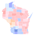
File:2021 Wisconsin Superintendent of Public Instruction primary election results map by county.svg

Original file (SVG file, nominally 810 × 810 pixels, file size: 43 KB)
Captions
Captions
Summary
[edit]| Description2021 Wisconsin Superintendent of Public Instruction primary election results map by county.svg |
English: Results of the 2021 Wisconsin Superintendent of Public Instruction Primary Election by county
Data from https://elections.ap.org/dailykos/results/2021-02-16/state/WI/race/0/raceid/50936 |
| Date | |
| Source | Own work |
| Author | Elli |
| This file has been created using a standardized map of a state's counties: Wisconsin county map, cb 500k.svg. A full list of available maps exists at Category:Standardized SVG county maps of US states. |
 |
Licensing
[edit]| This file is made available under the Creative Commons CC0 1.0 Universal Public Domain Dedication. | |
| The person who associated a work with this deed has dedicated the work to the public domain by waiving all of their rights to the work worldwide under copyright law, including all related and neighboring rights, to the extent allowed by law. You can copy, modify, distribute and perform the work, even for commercial purposes, all without asking permission.
http://creativecommons.org/publicdomain/zero/1.0/deed.enCC0Creative Commons Zero, Public Domain Dedicationfalsefalse |
File history
Click on a date/time to view the file as it appeared at that time.
| Date/Time | Thumbnail | Dimensions | User | Comment | |
|---|---|---|---|---|---|
| current | 21:47, 8 May 2024 |  | 810 × 810 (43 KB) | Talthiel (talk | contribs) | Changing colors to fit a nonpartisan election color scheme |
| 03:57, 9 April 2021 |  | 744 × 744 (233 KB) | WikiBunny2K1 (talk | contribs) | Reverted to version as of 16:54, 8 April 2021 (UTC) Tyler, your actions are only annoying fellow editors. We are working to standardized county maps with more accurate shapes, regardless if you think they look "good" or not. | |
| 21:41, 8 April 2021 |  | 245 × 262 (27 KB) | TylerKutschbach (talk | contribs) | Reverted to version as of 09:44, 8 April 2021 (UTC) these shapes are unnecessary and don’t look good | |
| 16:54, 8 April 2021 |  | 744 × 744 (233 KB) | Elli (talk | contribs) | Reverted to version as of 05:14, 7 April 2021 (UTC) this is literally a map I uploaded. Please stop your undiscussed reverting. | |
| 09:44, 8 April 2021 |  | 245 × 262 (27 KB) | TylerKutschbach (talk | contribs) | Reverted to version as of 05:33, 17 February 2021 (UTC) unnecessary shapes | |
| 05:14, 7 April 2021 |  | 744 × 744 (233 KB) | Elli (talk | contribs) | shapes | |
| 05:33, 17 February 2021 |  | 245 × 262 (27 KB) | Elli (talk | contribs) | Uploaded own work with UploadWizard |
You cannot overwrite this file.
File usage on Commons
The following 4 pages use this file:
File usage on other wikis
The following other wikis use this file:
- Usage on en.wikipedia.org
Metadata
This file contains additional information such as Exif metadata which may have been added by the digital camera, scanner, or software program used to create or digitize it. If the file has been modified from its original state, some details such as the timestamp may not fully reflect those of the original file. The timestamp is only as accurate as the clock in the camera, and it may be completely wrong.
| Width | 810 |
|---|---|
| Height | 810 |