File:2021-05-21 Blitar Earthquake Shakemap.jpg
Jump to navigation
Jump to search

Size of this preview: 512 × 600 pixels. Other resolutions: 205 × 240 pixels | 612 × 717 pixels.
Original file (612 × 717 pixels, file size: 241 KB, MIME type: image/jpeg)
Captions
Captions
Add a one-line explanation of what this file represents
Summary
[edit]
| Description |
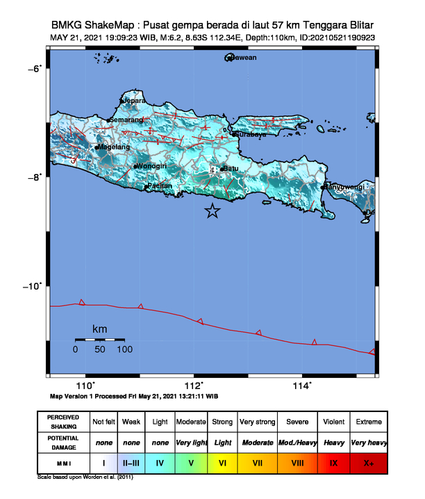
English: Shakemap from BMKG for the magnitude 5.9 earthquake southeast of Blitar, East Java |
| Date | |
| Source | https://ews.bmkg.go.id/TEWS/data/20210521190923.mmi.jpg |
| Author | Badan Meteorologi, Klimatologi, dan Geofisika |
Licensing
[edit]
| This file is in the public domain in Indonesia, because it is published and distributed by the Government of Republic of Indonesia, according to Article 43 of Law 28 of 2014 on copyrights.
There shall be no infringement of Copyright for:
|
 |
File history
Click on a date/time to view the file as it appeared at that time.
| Date/Time | Thumbnail | Dimensions | User | Comment | |
|---|---|---|---|---|---|
| current | 12:15, 22 May 2021 | | 612 × 717 (241 KB) | NFarras (talk | contribs) | Uploaded a work by Badan Meteorologi, Klimatologi, dan Geofisika from https://ews.bmkg.go.id/TEWS/data/20210521190923.mmi.jpg with UploadWizard |
You cannot overwrite this file.
File usage on Commons
There are no pages that use this file.
File usage on other wikis
The following other wikis use this file:
- Usage on id.wikipedia.org
- Usage on ms.wikipedia.org